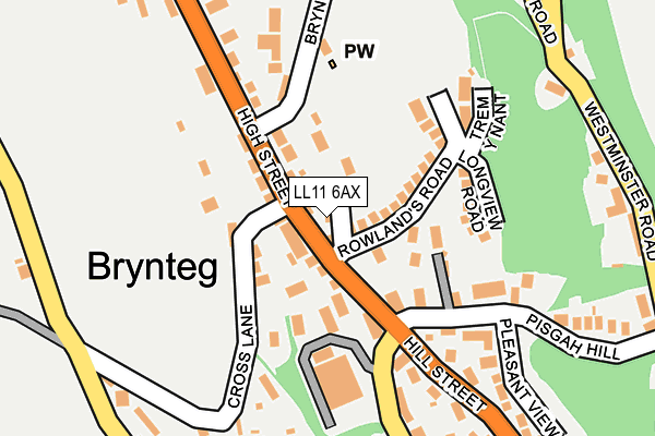
LL11 6AX lies on Maelor Close in Pentre Broughton, Wrexham. LL11 6AX is located in the Bryn Cefn electoral ward, within the unitary authority of Wrexham and the Welsh Parliamentary constituency of Clwyd South. The Local Health Board is Betsi Cadwaladr University and the police force is North Wales. This postcode has been in use since December 1995.


GetTheData
Source: OS OpenMap – Local (Ordnance Survey)
Source: OS VectorMap District (Ordnance Survey)
Licence: Open Government Licence (requires attribution)
| Easting | 330543 |
| Northing | 353102 |
| Latitude | 53.070618 |
| Longitude | -3.038096 |
GetTheData
Source: Open Postcode Geo
Licence: Open Government Licence
| Street | Maelor Close |
| Locality | Pentre Broughton |
| Town/City | Wrexham |
| Country | Wales |
| Postcode District | LL11 |
| ➜ LL11 open data dashboard ➜ See where LL11 is on a map ➜ Where is Brynteg? | |
GetTheData
Source: Land Registry Price Paid Data
Licence: Open Government Licence
Elevation or altitude of LL11 6AX as distance above sea level:
| Metres | Feet | |
|---|---|---|
| Elevation | 190m | 623ft |
Elevation is measured from the approximate centre of the postcode, to the nearest point on an OS contour line from OS Terrain 50, which has contour spacing of ten vertical metres.
➜ How high above sea level am I? Find the elevation of your current position using your device's GPS.
GetTheData
Source: Open Postcode Elevation
Licence: Open Government Licence
| Ward | Bryn Cefn |
| Constituency | Clwyd South |
GetTheData
Source: ONS Postcode Database
Licence: Open Government Licence
1, MAELOR CLOSE, PENTRE BROUGHTON, WREXHAM, LL11 6AX 1995 27 JAN £57,500 |
GetTheData
Source: HM Land Registry Price Paid Data
Licence: Contains HM Land Registry data © Crown copyright and database right 2024. This data is licensed under the Open Government Licence v3.0.
| June 2022 | Anti-social behaviour | On or near Longview Road | 136m |
| June 2022 | Criminal damage and arson | On or near Craigwen Road | 271m |
| May 2022 | Anti-social behaviour | On or near Moss Road | 436m |
| ➜ Maelor Close crime map and outcomes | |||
GetTheData
Source: data.police.uk
Licence: Open Government Licence
| Cross Foxes Inn (High Street) | Pentre Broughton | 43m |
| Cross Foxes Inn (High Street) | Pentre Broughton | 49m |
| White Hart Inn (High Street) | Pentre Broughton | 88m |
| White Hart Inn (High Street) | Pentre Broughton | 92m |
| October House (Westminster Road) | Moss | 251m |
| Gwersyllt Station | 1.4km |
| Cefn-y-Bedd Station | 3.2km |
| Wrexham General Station | 3.3km |
GetTheData
Source: NaPTAN
Licence: Open Government Licence
| Percentage of properties with Next Generation Access | 100.0% |
| Percentage of properties with Superfast Broadband | 100.0% |
| Percentage of properties with Ultrafast Broadband | 0.0% |
| Percentage of properties with Full Fibre Broadband | 0.0% |
Superfast Broadband is between 30Mbps and 300Mbps
Ultrafast Broadband is > 300Mbps
| Percentage of properties unable to receive 2Mbps | 0.0% |
| Percentage of properties unable to receive 5Mbps | 0.0% |
| Percentage of properties unable to receive 10Mbps | 0.0% |
| Percentage of properties unable to receive 30Mbps | 0.0% |
GetTheData
Source: Ofcom
Licence: Ofcom Terms of Use (requires attribution)
GetTheData
Source: ONS Postcode Database
Licence: Open Government Licence


➜ Get more ratings from the Food Standards Agency
GetTheData
Source: Food Standards Agency
Licence: FSA terms & conditions
| Last Collection | |||
|---|---|---|---|
| Location | Mon-Fri | Sat | Distance |
| Lodge | 11:30 | 10:45 | 502m |
| Coed Efa | 12:15 | 11:30 | 601m |
| Summerhill Post Office | 16:00 | 09:45 | 793m |
GetTheData
Source: Dracos
Licence: Creative Commons Attribution-ShareAlike
| School | Phase of Education | Distance |
|---|---|---|
| Black Lane C.P. School Long Lane, Pentre Broughton, Wrexham, LL11 6BT | Not applicable | 490m |
| Brynteg County School Maesteg, Brynteg, Wrexham, LL11 6NB | Not applicable | 646m |
| Ysgol Heulfan Sunny View, Gwersylit, Wrexham, LL11 4HS | Not applicable | 907m |
GetTheData
Source: Edubase
Licence: Open Government Licence
The below table lists the International Territorial Level (ITL) codes (formerly Nomenclature of Territorial Units for Statistics (NUTS) codes) and Local Administrative Units (LAU) codes for LL11 6AX:
| ITL 1 Code | Name |
|---|---|
| TLL | Wales |
| ITL 2 Code | Name |
| TLL2 | East Wales |
| ITL 3 Code | Name |
| TLL23 | Flintshire and Wrexham |
| LAU 1 Code | Name |
| W06000006 | Wrexham |
GetTheData
Source: ONS Postcode Directory
Licence: Open Government Licence
The below table lists the Census Output Area (OA), Lower Layer Super Output Area (LSOA), and Middle Layer Super Output Area (MSOA) for LL11 6AX:
| Code | Name | |
|---|---|---|
| OA | W00001887 | |
| LSOA | W01000351 | Wrexham 005A |
| MSOA | W02000082 | Wrexham 005 |
GetTheData
Source: ONS Postcode Directory
Licence: Open Government Licence
| LL11 6AG | High Street | 55m |
| LL11 6AP | Rowlands Road | 61m |
| LL11 6AR | Cross Lane | 82m |
| LL11 6AL | High Street | 99m |
| LL11 6DE | Matthias Road | 117m |
| LL11 6DJ | Longview Road | 128m |
| LL11 6DD | Pisgah Hill | 163m |
| LL11 6DQ | Trem Y Nant | 169m |
| LL11 6DB | Pisgah Hill | 190m |
| LL11 6AT | Bryn Y Gaer Road | 193m |
GetTheData
Source: Open Postcode Geo; Land Registry Price Paid Data
Licence: Open Government Licence