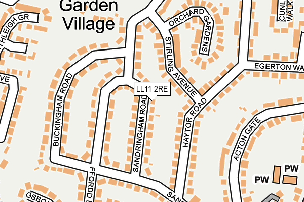
LL11 2RE lies on Sandringham Road in Wrexham. LL11 2RE is located in the Garden Village electoral ward, within the unitary authority of Wrexham and the Welsh Parliamentary constituency of Wrexham. The Local Health Board is Betsi Cadwaladr University and the police force is North Wales. This postcode has been in use since January 1980.


GetTheData
Source: OS OpenMap – Local (Ordnance Survey)
Source: OS VectorMap District (Ordnance Survey)
Licence: Open Government Licence (requires attribution)
| Easting | 333403 |
| Northing | 351971 |
| Latitude | 53.060818 |
| Longitude | -2.995183 |
GetTheData
Source: Open Postcode Geo
Licence: Open Government Licence
| Street | Sandringham Road |
| Town/City | Wrexham |
| Country | Wales |
| Postcode District | LL11 |
➜ See where LL11 is on a map ➜ Where is Wrexham? | |
GetTheData
Source: Land Registry Price Paid Data
Licence: Open Government Licence
Elevation or altitude of LL11 2RE as distance above sea level:
| Metres | Feet | |
|---|---|---|
| Elevation | 100m | 328ft |
Elevation is measured from the approximate centre of the postcode, to the nearest point on an OS contour line from OS Terrain 50, which has contour spacing of ten vertical metres.
➜ How high above sea level am I? Find the elevation of your current position using your device's GPS.
GetTheData
Source: Open Postcode Elevation
Licence: Open Government Licence
| Ward | Garden Village |
| Constituency | Wrexham |
GetTheData
Source: ONS Postcode Database
Licence: Open Government Licence
58, SANDRINGHAM ROAD, WREXHAM, LL11 2RE 2022 7 NOV £317,000 |
2021 15 JUN £337,500 |
2017 25 MAY £249,950 |
2005 10 JUN £242,000 |
2004 1 MAR £198,500 |
GetTheData
Source: HM Land Registry Price Paid Data
Licence: Contains HM Land Registry data © Crown copyright and database right 2025. This data is licensed under the Open Government Licence v3.0.
| Sandringham Road | Garden Village | 82m |
| Sandway Road (Sandringham Road) | Garden Village | 93m |
| Buckingham Road | Garden Village | 130m |
| Sterling Avenue (Wat's Dyke Way) | Garden Village | 179m |
| Sandway Road | Garden Village | 182m |
| Wrexham General Station | 1.3km |
| Wrexham Central Station | 1.6km |
| Gwersyllt Station | 2km |
GetTheData
Source: NaPTAN
Licence: Open Government Licence
| Percentage of properties with Next Generation Access | 100.0% |
| Percentage of properties with Superfast Broadband | 100.0% |
| Percentage of properties with Ultrafast Broadband | 100.0% |
| Percentage of properties with Full Fibre Broadband | 100.0% |
Superfast Broadband is between 30Mbps and 300Mbps
Ultrafast Broadband is > 300Mbps
| Median download speed | 54.8Mbps |
| Average download speed | 79.9Mbps |
| Maximum download speed | 350.00Mbps |
| Median upload speed | 5.2Mbps |
| Average upload speed | 8.0Mbps |
| Maximum upload speed | 20.00Mbps |
| Percentage of properties unable to receive 2Mbps | 0.0% |
| Percentage of properties unable to receive 5Mbps | 0.0% |
| Percentage of properties unable to receive 10Mbps | 0.0% |
| Percentage of properties unable to receive 30Mbps | 0.0% |
GetTheData
Source: Ofcom
Licence: Ofcom Terms of Use (requires attribution)
Estimated total energy consumption in LL11 2RE by fuel type, 2015.
| Consumption (kWh) | 387,898 |
|---|---|
| Meter count | 30 |
| Mean (kWh/meter) | 12,930 |
| Median (kWh/meter) | 11,487 |
| Consumption (kWh) | 88,358 |
|---|---|
| Meter count | 26 |
| Mean (kWh/meter) | 3,398 |
| Median (kWh/meter) | 2,884 |
GetTheData
Source: Postcode level gas estimates: 2015 (experimental)
Source: Postcode level electricity estimates: 2015 (experimental)
Licence: Open Government Licence
GetTheData
Source: ONS Postcode Database
Licence: Open Government Licence


➜ Get more ratings from the Food Standards Agency
GetTheData
Source: Food Standards Agency
Licence: FSA terms & conditions
| Last Collection | |||
|---|---|---|---|
| Location | Mon-Fri | Sat | Distance |
| Rhosrobin Post Office | 17:15 | 10:30 | 1,118m |
| Old Rhosrobin | 16:00 | 07:30 | 1,126m |
| Turf Hotel | 16:00 | 11:30 | 1,254m |
GetTheData
Source: Dracos
Licence: Creative Commons Attribution-ShareAlike
The below table lists the International Territorial Level (ITL) codes (formerly Nomenclature of Territorial Units for Statistics (NUTS) codes) and Local Administrative Units (LAU) codes for LL11 2RE:
| ITL 1 Code | Name |
|---|---|
| TLL | Wales |
| ITL 2 Code | Name |
| TLL2 | East Wales |
| ITL 3 Code | Name |
| TLL23 | Flintshire and Wrexham |
| LAU 1 Code | Name |
| W06000006 | Wrexham |
GetTheData
Source: ONS Postcode Directory
Licence: Open Government Licence
The below table lists the Census Output Area (OA), Lower Layer Super Output Area (LSOA), and Middle Layer Super Output Area (MSOA) for LL11 2RE:
| Code | Name | |
|---|---|---|
| OA | W00001969 | |
| LSOA | W01000368 | Wrexham 008A |
| MSOA | W02000085 | Wrexham 008 |
GetTheData
Source: ONS Postcode Directory
Licence: Open Government Licence
| LL11 2RF | Sandringham Road | 50m |
| LL11 2RG | Edinburgh Road | 90m |
| LL11 2RA | Stirling Avenue | 90m |
| LL11 2PT | Haytor Road | 135m |
| LL11 2PU | Haytor Road | 138m |
| LL11 2RD | Sandway Road | 145m |
| LL11 2RH | Buckingham Road | 161m |
| LL11 2PW | Acton Gate | 176m |
| LL11 2TJ | Parc Bychan | 181m |
| LL11 2RS | Orchard Gardens | 181m |
GetTheData
Source: Open Postcode Geo; Land Registry Price Paid Data
Licence: Open Government Licence