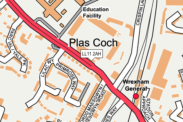
LL11 2AH is located in the Grosvenor electoral ward, within the unitary authority of Wrexham and the Welsh Parliamentary constituency of Wrexham. The Local Health Board is Betsi Cadwaladr University and the police force is North Wales. This postcode has been in use since January 1980.


GetTheData
Source: OS OpenMap – Local (Ordnance Survey)
Source: OS VectorMap District (Ordnance Survey)
Licence: Open Government Licence (requires attribution)
| Easting | 332779 |
| Northing | 350947 |
| Latitude | 53.051552 |
| Longitude | -3.004279 |
GetTheData
Source: Open Postcode Geo
Licence: Open Government Licence
| Country | Wales |
| Postcode District | LL11 |
| ➜ LL11 open data dashboard ➜ See where LL11 is on a map ➜ Where is Wrexham? | |
GetTheData
Source: Land Registry Price Paid Data
Licence: Open Government Licence
Elevation or altitude of LL11 2AH as distance above sea level:
| Metres | Feet | |
|---|---|---|
| Elevation | 90m | 295ft |
Elevation is measured from the approximate centre of the postcode, to the nearest point on an OS contour line from OS Terrain 50, which has contour spacing of ten vertical metres.
➜ How high above sea level am I? Find the elevation of your current position using your device's GPS.
GetTheData
Source: Open Postcode Elevation
Licence: Open Government Licence
| Ward | Grosvenor |
| Constituency | Wrexham |
GetTheData
Source: ONS Postcode Database
Licence: Open Government Licence
| January 2024 | Anti-social behaviour | On or near Grosvenor Gardens | 370m |
| December 2023 | Violence and sexual offences | On or near Grosvenor Gardens | 370m |
| December 2023 | Anti-social behaviour | On or near Grosvenor Gardens | 370m |
| ➜ Get more crime data in our Crime section | |||
GetTheData
Source: data.police.uk
Licence: Open Government Licence
| Football Ground (Mold Road) | Wrexham | 35m |
| Racecourse (Mold Road) | Wrexham | 64m |
| Maesgwyn Road (Regent Street) | Rhosddu | 133m |
| Crispin Lane | Rhosddu | 197m |
| Wrexham General Station (Regent Street) | Rhosddu | 212m |
| Wrexham General Station | 0.2km |
| Wrexham Central Station | 0.7km |
| Gwersyllt Station | 2.5km |
GetTheData
Source: NaPTAN
Licence: Open Government Licence
GetTheData
Source: ONS Postcode Database
Licence: Open Government Licence


➜ Get more ratings from the Food Standards Agency
GetTheData
Source: Food Standards Agency
Licence: FSA terms & conditions
| Last Collection | |||
|---|---|---|---|
| Location | Mon-Fri | Sat | Distance |
| Turf Hotel | 16:00 | 11:30 | 118m |
| Wrexham Delivery Office | 18:30 | 13:30 | 360m |
| Wrexham Sorting Office | 18:30 | 13:30 | 439m |
GetTheData
Source: Dracos
Licence: Creative Commons Attribution-ShareAlike
| School | Phase of Education | Distance |
|---|---|---|
| Rhosddu Primary School Price's Lane, Rhosddu, Wrexham, LL11 2NB | Not applicable | 635m |
| Ysgol Plas Coch Ffordd Stansty, Plas Coch, Wrexham, LL11 2BU | Not applicable | 749m |
| Woodlands Children's Development Centre 7 Pierces Square, Wrecsam, LL13 7NE | Not applicable | 819m |
GetTheData
Source: Edubase
Licence: Open Government Licence
The below table lists the International Territorial Level (ITL) codes (formerly Nomenclature of Territorial Units for Statistics (NUTS) codes) and Local Administrative Units (LAU) codes for LL11 2AH:
| ITL 1 Code | Name |
|---|---|
| TLL | Wales |
| ITL 2 Code | Name |
| TLL2 | East Wales |
| ITL 3 Code | Name |
| TLL23 | Flintshire and Wrexham |
| LAU 1 Code | Name |
| W06000006 | Wrexham |
GetTheData
Source: ONS Postcode Directory
Licence: Open Government Licence
The below table lists the Census Output Area (OA), Lower Layer Super Output Area (LSOA), and Middle Layer Super Output Area (MSOA) for LL11 2AH:
| Code | Name | |
|---|---|---|
| OA | W00001989 | |
| LSOA | W01000372 | Wrexham 008C |
| MSOA | W02000085 | Wrexham 008 |
GetTheData
Source: ONS Postcode Directory
Licence: Open Government Licence
| LL11 2AE | Mold Road | 56m |
| LL11 2AT | Primrose Way | 110m |
| LL11 2BB | Lilac Way | 141m |
| LL11 2AF | Mold Road | 162m |
| LL11 2AP | Maesgwyn Road | 218m |
| LL11 2AX | Yale Park | 224m |
| LL11 2AQ | Primrose Way | 224m |
| LL11 2AY | Plas Y Ffynnon | 274m |
| LL11 2BD | Windsor Drive | 316m |
| LL11 2NX | Spring Gardens | 340m |
GetTheData
Source: Open Postcode Geo; Land Registry Price Paid Data
Licence: Open Government Licence