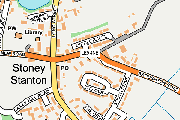
LE9 4NE is located in the Fosse Stoney Cove electoral ward, within the local authority district of Blaby and the English Parliamentary constituency of South Leicestershire. The Sub Integrated Care Board (ICB) Location is NHS Leicester, Leicestershire and Rutland ICB - 04V and the police force is Leicestershire. This postcode has been in use since September 2014.


GetTheData
Source: OS OpenMap – Local (Ordnance Survey)
Source: OS VectorMap District (Ordnance Survey)
Licence: Open Government Licence (requires attribution)
| Easting | 449193 |
| Northing | 294710 |
| Latitude | 52.548042 |
| Longitude | -1.275974 |
GetTheData
Source: Open Postcode Geo
Licence: Open Government Licence
| Country | England |
| Postcode District | LE9 |
| ➜ LE9 open data dashboard ➜ See where LE9 is on a map ➜ Where is Stoney Stanton? | |
GetTheData
Source: Land Registry Price Paid Data
Licence: Open Government Licence
Elevation or altitude of LE9 4NE as distance above sea level:
| Metres | Feet | |
|---|---|---|
| Elevation | 80m | 262ft |
Elevation is measured from the approximate centre of the postcode, to the nearest point on an OS contour line from OS Terrain 50, which has contour spacing of ten vertical metres.
➜ How high above sea level am I? Find the elevation of your current position using your device's GPS.
GetTheData
Source: Open Postcode Elevation
Licence: Open Government Licence
| Ward | Fosse Stoney Cove |
| Constituency | South Leicestershire |
GetTheData
Source: ONS Postcode Database
Licence: Open Government Licence
| January 2024 | Violence and sexual offences | On or near Parking Area | 378m |
| December 2023 | Vehicle crime | On or near Parking Area | 378m |
| December 2023 | Vehicle crime | On or near Parking Area | 378m |
| ➜ Get more crime data in our Crime section | |||
GetTheData
Source: data.police.uk
Licence: Open Government Licence
| New Road (Long Street) | Stoney Stanton | 132m |
| Bluebell Inn (Long Street) | Stoney Stanton | 140m |
| Bluebell Inn (Long Street) | Stoney Stanton | 182m |
| South Drive (Sapcote Road) | Stoney Stanton | 221m |
| St Michael's Church (New Road) | Stoney Stanton | 224m |
| Narborough Station | 5.6km |
GetTheData
Source: NaPTAN
Licence: Open Government Licence
| Percentage of properties with Next Generation Access | 100.0% |
| Percentage of properties with Superfast Broadband | 100.0% |
| Percentage of properties with Ultrafast Broadband | 0.0% |
| Percentage of properties with Full Fibre Broadband | 0.0% |
Superfast Broadband is between 30Mbps and 300Mbps
Ultrafast Broadband is > 300Mbps
| Percentage of properties unable to receive 2Mbps | 0.0% |
| Percentage of properties unable to receive 5Mbps | 0.0% |
| Percentage of properties unable to receive 10Mbps | 0.0% |
| Percentage of properties unable to receive 30Mbps | 0.0% |
GetTheData
Source: Ofcom
Licence: Ofcom Terms of Use (requires attribution)
GetTheData
Source: ONS Postcode Database
Licence: Open Government Licence


➜ Get more ratings from the Food Standards Agency
GetTheData
Source: Food Standards Agency
Licence: FSA terms & conditions
| Last Collection | |||
|---|---|---|---|
| Location | Mon-Fri | Sat | Distance |
| Sparkenhoe | 16:30 | 10:00 | 2,127m |
| Hill Street | 17:00 | 10:00 | 2,417m |
| Pochin Drive | 17:10 | 10:00 | 2,478m |
GetTheData
Source: Dracos
Licence: Creative Commons Attribution-ShareAlike
| Facility | Distance |
|---|---|
| South Drive Field (Closed) South Drive, Stoney Stanton, Leicester Grass Pitches | 225m |
| Stoney Stanton War Memorial Playing Fields Carey Hill Road, Stoney Stanton Grass Pitches, Squash Courts, Outdoor Tennis Courts | 394m |
| Huncote Road Fields (Closed) Huncote Road, Stoney Stanton, Leicester Grass Pitches | 910m |
GetTheData
Source: Active Places
Licence: Open Government Licence
| School | Phase of Education | Distance |
|---|---|---|
| Manorfield Church of England Primary School Station Road, Stoney Stanton, Leicester, LE9 4LU | Primary | 509m |
| All Saints Church of England Primary School, Sapcote Bassett Lane, Sapcote, Leicester, LE9 4FB | Primary | 1.6km |
| Croft Church of England Primary School Brookes Avenue, Croft, Leicester, LE9 3GJ | Primary | 2.2km |
GetTheData
Source: Edubase
Licence: Open Government Licence
The below table lists the International Territorial Level (ITL) codes (formerly Nomenclature of Territorial Units for Statistics (NUTS) codes) and Local Administrative Units (LAU) codes for LE9 4NE:
| ITL 1 Code | Name |
|---|---|
| TLF | East Midlands (England) |
| ITL 2 Code | Name |
| TLF2 | Leicestershire, Rutland and Northamptonshire |
| ITL 3 Code | Name |
| TLF22 | Leicestershire CC and Rutland |
| LAU 1 Code | Name |
| E07000129 | Blaby |
GetTheData
Source: ONS Postcode Directory
Licence: Open Government Licence
The below table lists the Census Output Area (OA), Lower Layer Super Output Area (LSOA), and Middle Layer Super Output Area (MSOA) for LE9 4NE:
| Code | Name | |
|---|---|---|
| OA | E00130232 | |
| LSOA | E01025663 | Blaby 012C |
| MSOA | E02005344 | Blaby 012 |
GetTheData
Source: ONS Postcode Directory
Licence: Open Government Licence
| LE9 4TS | Middleton Close | 40m |
| LE9 4JS | The Oval | 84m |
| LE9 4DQ | Long Street | 141m |
| LE9 4JP | South Drive | 170m |
| LE9 4TJ | Halls Court | 180m |
| LE9 4LQ | New Road | 198m |
| LE9 4DD | Elisha Close | 202m |
| LE9 4DA | Church Street | 221m |
| LE9 4TL | Stevens Close | 221m |
| LE9 4BZ | Johnson Rise | 267m |
GetTheData
Source: Open Postcode Geo; Land Registry Price Paid Data
Licence: Open Government Licence