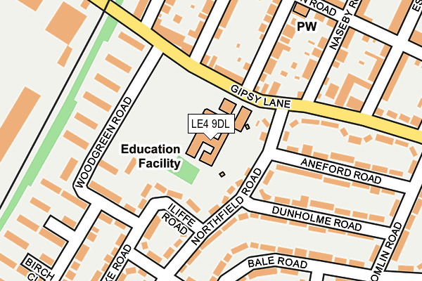
LE4 9DL is located in the Troon electoral ward, within the unitary authority of Leicester and the English Parliamentary constituency of Leicester East. The Sub Integrated Care Board (ICB) Location is NHS Leicester, Leicestershire and Rutland ICB - 04C and the police force is Leicestershire. This postcode has been in use since May 1994.


GetTheData
Source: OS OpenMap – Local (Ordnance Survey)
Source: OS VectorMap District (Ordnance Survey)
Licence: Open Government Licence (requires attribution)
| Easting | 461073 |
| Northing | 306391 |
| Latitude | 52.651820 |
| Longitude | -1.098660 |
GetTheData
Source: Open Postcode Geo
Licence: Open Government Licence
| Country | England |
| Postcode District | LE4 |
| ➜ LE4 open data dashboard ➜ See where LE4 is on a map ➜ Where is Leicester? | |
GetTheData
Source: Land Registry Price Paid Data
Licence: Open Government Licence
Elevation or altitude of LE4 9DL as distance above sea level:
| Metres | Feet | |
|---|---|---|
| Elevation | 60m | 197ft |
Elevation is measured from the approximate centre of the postcode, to the nearest point on an OS contour line from OS Terrain 50, which has contour spacing of ten vertical metres.
➜ How high above sea level am I? Find the elevation of your current position using your device's GPS.
GetTheData
Source: Open Postcode Elevation
Licence: Open Government Licence
| Ward | Troon |
| Constituency | Leicester East |
GetTheData
Source: ONS Postcode Database
Licence: Open Government Licence
| January 2024 | Violence and sexual offences | On or near Bale Road | 262m |
| December 2023 | Criminal damage and arson | On or near Bale Road | 262m |
| December 2023 | Burglary | On or near Bale Road | 262m |
| ➜ Get more crime data in our Crime section | |||
GetTheData
Source: data.police.uk
Licence: Open Government Licence
| Northfield Road (Gipsy Lane) | Leicester | 117m |
| Hampden Road (Edgehill Road) | Leicester | 128m |
| Hampden Road (Marston Road) | Leicester | 137m |
| Ireton Road (Gipsy Lane) | Humberstone | 309m |
| Ireton Road (Gipsy Lane) | Humberstone | 362m |
| Leicester Station | 2.9km |
| Syston Station | 4.8km |
GetTheData
Source: NaPTAN
Licence: Open Government Licence
GetTheData
Source: ONS Postcode Database
Licence: Open Government Licence


➜ Get more ratings from the Food Standards Agency
GetTheData
Source: Food Standards Agency
Licence: FSA terms & conditions
| Last Collection | |||
|---|---|---|---|
| Location | Mon-Fri | Sat | Distance |
| Willowbrook Road Post Office | 17:30 | 12:00 | 1,043m |
| Melrose St Post Office | 17:00 | 12:00 | 1,110m |
| Canon Street | 16:30 | 12:00 | 1,211m |
GetTheData
Source: Dracos
Licence: Creative Commons Attribution-ShareAlike
| Facility | Distance |
|---|---|
| Northfield House Primary Academy Northfield Road, Leicester Swimming Pool, Grass Pitches, Artificial Grass Pitch | 0m |
| The Emerald Centre Gipsy Lane, Leicester Grass Pitches | 450m |
| Be Fitter (Closed) Trevanth Road, Leicester Health and Fitness Gym | 740m |
GetTheData
Source: Active Places
Licence: Open Government Licence
| School | Phase of Education | Distance |
|---|---|---|
| North Mead Primary Academy Northfield Road, Leicester, LE4 9DL | Primary | 0m |
| Wyvern Primary School Wyvern Avenue, Leicester, LE4 7HH | Primary | 710m |
| Oakham House 493 Gypsy Lane, Humberstone, Leicester, LE5 0TD | Not applicable | 723m |
GetTheData
Source: Edubase
Licence: Open Government Licence
The below table lists the International Territorial Level (ITL) codes (formerly Nomenclature of Territorial Units for Statistics (NUTS) codes) and Local Administrative Units (LAU) codes for LE4 9DL:
| ITL 1 Code | Name |
|---|---|
| TLF | East Midlands (England) |
| ITL 2 Code | Name |
| TLF2 | Leicestershire, Rutland and Northamptonshire |
| ITL 3 Code | Name |
| TLF21 | Leicester |
| LAU 1 Code | Name |
| E06000016 | Leicester |
GetTheData
Source: ONS Postcode Directory
Licence: Open Government Licence
The below table lists the Census Output Area (OA), Lower Layer Super Output Area (LSOA), and Middle Layer Super Output Area (MSOA) for LE4 9DL:
| Code | Name | |
|---|---|---|
| OA | E00068929 | |
| LSOA | E01013652 | Leicester 011B |
| MSOA | E02002837 | Leicester 011 |
GetTheData
Source: ONS Postcode Directory
Licence: Open Government Licence
| LE4 9DH | Northfield Road | 81m |
| LE4 9DG | Iliffe Road | 87m |
| LE4 9DJ | Northfield Road | 121m |
| LE4 7BZ | Gipsy Lane | 135m |
| LE4 9UE | Woodgreen Road | 145m |
| LE4 9EA | Edgehill Road | 161m |
| LE4 7DA | Gipsy Lane | 164m |
| LE4 9UB | Woodgreen Road | 173m |
| LE4 9UA | Gipsy Lane | 179m |
| LE4 9BF | Bale Road | 181m |
GetTheData
Source: Open Postcode Geo; Land Registry Price Paid Data
Licence: Open Government Licence