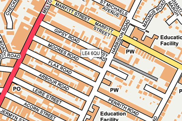
LE4 6QU is located in the Rushey Mead electoral ward, within the unitary authority of Leicester and the English Parliamentary constituency of Leicester East. The Sub Integrated Care Board (ICB) Location is NHS Leicester, Leicestershire and Rutland ICB - 04C and the police force is Leicestershire. This postcode has been in use since June 2009.


GetTheData
Source: OS OpenMap – Local (Ordnance Survey)
Source: OS VectorMap District (Ordnance Survey)
Licence: Open Government Licence (requires attribution)
| Easting | 459995 |
| Northing | 306805 |
| Latitude | 52.655662 |
| Longitude | -1.114517 |
GetTheData
Source: Open Postcode Geo
Licence: Open Government Licence
| Country | England |
| Postcode District | LE4 |
| ➜ LE4 open data dashboard ➜ See where LE4 is on a map ➜ Where is Leicester? | |
GetTheData
Source: Land Registry Price Paid Data
Licence: Open Government Licence
Elevation or altitude of LE4 6QU as distance above sea level:
| Metres | Feet | |
|---|---|---|
| Elevation | 60m | 197ft |
Elevation is measured from the approximate centre of the postcode, to the nearest point on an OS contour line from OS Terrain 50, which has contour spacing of ten vertical metres.
➜ How high above sea level am I? Find the elevation of your current position using your device's GPS.
GetTheData
Source: Open Postcode Elevation
Licence: Open Government Licence
| Ward | Rushey Mead |
| Constituency | Leicester East |
GetTheData
Source: ONS Postcode Database
Licence: Open Government Licence
| January 2024 | Bicycle theft | On or near Stafford Street | 346m |
| January 2024 | Anti-social behaviour | On or near Petrol Station | 461m |
| January 2024 | Burglary | On or near Petrol Station | 461m |
| ➜ Get more crime data in our Crime section | |||
GetTheData
Source: data.police.uk
Licence: Open Government Licence
| Melton Road (Marfitt Street) | Belgrave | 182m |
| Melton Road (Marfitt Street) | Belgrave | 195m |
| Moores Road (Melton Road) | Belgrave | 214m |
| Moores Road (Melton Road) | Belgrave | 220m |
| Arbour Road (Melton Road) | Belgrave | 245m |
| Leicester North (Great Central Railway) | Birstall | 1,809m |
| Leicester Station | 2.8km |
| Syston Station | 4.8km |
GetTheData
Source: NaPTAN
Licence: Open Government Licence
| Percentage of properties with Next Generation Access | 100.0% |
| Percentage of properties with Superfast Broadband | 100.0% |
| Percentage of properties with Ultrafast Broadband | 100.0% |
| Percentage of properties with Full Fibre Broadband | 0.0% |
Superfast Broadband is between 30Mbps and 300Mbps
Ultrafast Broadband is > 300Mbps
| Percentage of properties unable to receive 2Mbps | 0.0% |
| Percentage of properties unable to receive 5Mbps | 0.0% |
| Percentage of properties unable to receive 10Mbps | 0.0% |
| Percentage of properties unable to receive 30Mbps | 0.0% |
GetTheData
Source: Ofcom
Licence: Ofcom Terms of Use (requires attribution)
GetTheData
Source: ONS Postcode Database
Licence: Open Government Licence


➜ Get more ratings from the Food Standards Agency
GetTheData
Source: Food Standards Agency
Licence: FSA terms & conditions
| Last Collection | |||
|---|---|---|---|
| Location | Mon-Fri | Sat | Distance |
| Melton Road/Melton Turn | 17:30 | 12:00 | 241m |
| Leire Street Post Office | 17:15 | 12:00 | 269m |
| Canon Street | 16:30 | 12:00 | 378m |
GetTheData
Source: Dracos
Licence: Creative Commons Attribution-ShareAlike
| Facility | Distance |
|---|---|
| Rushey Fields Recreation Ground Harrison Road, Leicester Grass Pitches, Outdoor Tennis Courts | 493m |
| Cossington Street Sports Centre Cossington Street, Leicester Sports Hall, Swimming Pool, Health and Fitness Gym, Studio | 659m |
| Rushey Mead Academy Melton Road, Leicester Health and Fitness Gym, Grass Pitches, Sports Hall | 702m |
GetTheData
Source: Active Places
Licence: Open Government Licence
| School | Phase of Education | Distance |
|---|---|---|
| Saint Patrick's Catholic Voluntary Academy Harrison Road, Leicester, LE4 6QN | Primary | 173m |
| Rushey Mead Primary School Gipsy Lane, Leicester, LE4 6RB | Primary | 195m |
| Mellor Community Primary School 60 Checketts Road, LEICESTER, LE4 5EQ | Primary | 326m |
GetTheData
Source: Edubase
Licence: Open Government Licence
The below table lists the International Territorial Level (ITL) codes (formerly Nomenclature of Territorial Units for Statistics (NUTS) codes) and Local Administrative Units (LAU) codes for LE4 6QU:
| ITL 1 Code | Name |
|---|---|
| TLF | East Midlands (England) |
| ITL 2 Code | Name |
| TLF2 | Leicestershire, Rutland and Northamptonshire |
| ITL 3 Code | Name |
| TLF21 | Leicester |
| LAU 1 Code | Name |
| E06000016 | Leicester |
GetTheData
Source: ONS Postcode Directory
Licence: Open Government Licence
The below table lists the Census Output Area (OA), Lower Layer Super Output Area (LSOA), and Middle Layer Super Output Area (MSOA) for LE4 6QU:
| Code | Name | |
|---|---|---|
| OA | E00068802 | |
| LSOA | E01013630 | Leicester 007E |
| MSOA | E02002833 | Leicester 007 |
GetTheData
Source: ONS Postcode Directory
Licence: Open Government Licence
| LE4 6QL | Harrison Road | 49m |
| LE4 6QJ | Gipsy Road | 81m |
| LE4 6QN | Harrison Road | 81m |
| LE4 6QH | Gipsy Road | 84m |
| LE4 6QQ | Moores Road | 85m |
| LE4 6QR | Moores Road | 86m |
| LE4 6QD | Flax Road | 94m |
| LE4 6RQ | Northumberland Avenue | 105m |
| LE4 6QE | Flax Road | 113m |
| LE4 6RP | Marfitt Street | 130m |
GetTheData
Source: Open Postcode Geo; Land Registry Price Paid Data
Licence: Open Government Licence