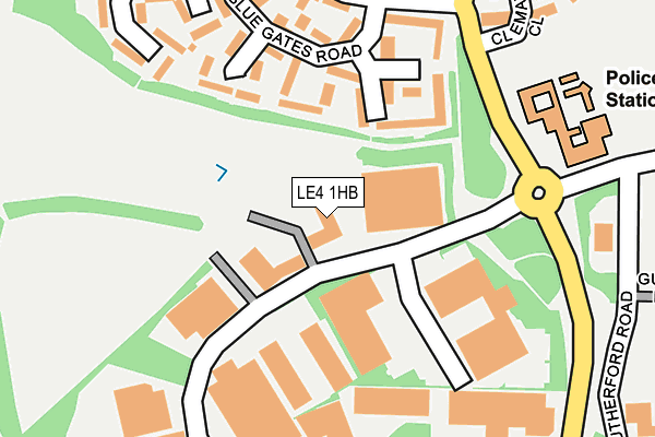
LE4 1HB is located in the Beaumont Leys electoral ward, within the unitary authority of Leicester and the English Parliamentary constituency of Leicester West. The Sub Integrated Care Board (ICB) Location is NHS Leicester, Leicestershire and Rutland ICB - 04C and the police force is Leicestershire. This postcode has been in use since August 1993.


GetTheData
Source: OS OpenMap – Local (Ordnance Survey)
Source: OS VectorMap District (Ordnance Survey)
Licence: Open Government Licence (requires attribution)
| Easting | 456053 |
| Northing | 308018 |
| Latitude | 52.667285 |
| Longitude | -1.172790 |
GetTheData
Source: Open Postcode Geo
Licence: Open Government Licence
| Country | England |
| Postcode District | LE4 |
| ➜ LE4 open data dashboard ➜ See where LE4 is on a map ➜ Where is Leicester? | |
GetTheData
Source: Land Registry Price Paid Data
Licence: Open Government Licence
Elevation or altitude of LE4 1HB as distance above sea level:
| Metres | Feet | |
|---|---|---|
| Elevation | 80m | 262ft |
Elevation is measured from the approximate centre of the postcode, to the nearest point on an OS contour line from OS Terrain 50, which has contour spacing of ten vertical metres.
➜ How high above sea level am I? Find the elevation of your current position using your device's GPS.
GetTheData
Source: Open Postcode Elevation
Licence: Open Government Licence
| Ward | Beaumont Leys |
| Constituency | Leicester West |
GetTheData
Source: ONS Postcode Database
Licence: Open Government Licence
| June 2022 | Criminal damage and arson | On or near Blue Gates Road | 164m |
| June 2022 | Violence and sexual offences | On or near Blue Gates Road | 164m |
| June 2022 | Public order | On or near Blue Gates Road | 164m |
| ➜ Get more crime data in our Crime section | |||
GetTheData
Source: data.police.uk
Licence: Open Government Licence
| Beaumont Way (Bennion Road) | Beaumont Leys | 212m |
| Beaumont Centre (Bennion Road) | Beaumont Leys | 276m |
| Heatherbrook Road (Bennion Road) | Beaumont Leys | 281m |
| Beaumont Centre (Bennion Road) | Beaumont Leys | 282m |
| Beaumont Centre (Rutherford Road) | Beaumont Leys | 282m |
| Leicester Station | 5.1km |
GetTheData
Source: NaPTAN
Licence: Open Government Licence
Estimated total energy consumption in LE4 1HB by fuel type, 2015.
| Consumption (kWh) | 72,494 |
|---|---|
| Meter count | 45 |
| Mean (kWh/meter) | 1,611 |
| Median (kWh/meter) | 558 |
GetTheData
Source: Postcode level gas estimates: 2015 (experimental)
Source: Postcode level electricity estimates: 2015 (experimental)
Licence: Open Government Licence
GetTheData
Source: ONS Postcode Database
Licence: Open Government Licence


➜ Get more ratings from the Food Standards Agency
GetTheData
Source: Food Standards Agency
Licence: FSA terms & conditions
| Last Collection | |||
|---|---|---|---|
| Location | Mon-Fri | Sat | Distance |
| Boston Road | 18:30 | 12:00 | 264m |
| Boston Road | 18:30 | 265m | |
| Bennion Road | 17:30 | 12:00 | 282m |
GetTheData
Source: Dracos
Licence: Creative Commons Attribution-ShareAlike
| Facility | Distance |
|---|---|
| Leicester Leys Leisure Centre Beaumont Way, Leicester Sports Hall, Swimming Pool, Health and Fitness Gym, Squash Courts, Studio | 420m |
| Beaumont Park Bennion Road, Leicester Grass Pitches, Artificial Grass Pitch | 495m |
| Heatherbrook Primary Academy Astill Lodge Road, Beaumont Leys, Leicester Grass Pitches | 601m |
GetTheData
Source: Active Places
Licence: Open Government Licence
| School | Phase of Education | Distance |
|---|---|---|
| Heatherbrook Primary Academy Astill Lodge Road, Beaumont Leys, Leicester, LE4 1BE | Primary | 601m |
| Buswells Lodge Primary School Beauville Drive, Beaumont Leys, Leicester, LE4 0PT | Primary | 776m |
| Buswells Lodge Primary School Beauville Drive, Beaumont Leys, Leicester, LE4 0PT | Primary | 776m |
GetTheData
Source: Edubase
Licence: Open Government Licence
The below table lists the International Territorial Level (ITL) codes (formerly Nomenclature of Territorial Units for Statistics (NUTS) codes) and Local Administrative Units (LAU) codes for LE4 1HB:
| ITL 1 Code | Name |
|---|---|
| TLF | East Midlands (England) |
| ITL 2 Code | Name |
| TLF2 | Leicestershire, Rutland and Northamptonshire |
| ITL 3 Code | Name |
| TLF21 | Leicester |
| LAU 1 Code | Name |
| E06000016 | Leicester |
GetTheData
Source: ONS Postcode Directory
Licence: Open Government Licence
The below table lists the Census Output Area (OA), Lower Layer Super Output Area (LSOA), and Middle Layer Super Output Area (MSOA) for LE4 1HB:
| Code | Name | |
|---|---|---|
| OA | E00068760 | |
| LSOA | E01013617 | Leicester 004A |
| MSOA | E02002830 | Leicester 004 |
GetTheData
Source: ONS Postcode Directory
Licence: Open Government Licence
| LE4 1AW | Boston Road | 107m |
| LE4 1AB | Blue Gates Road | 151m |
| LE4 1AD | Blue Gates Road | 166m |
| LE4 1AF | Blue Gates Road | 210m |
| LE4 1AJ | Heatherbrook Road | 249m |
| LE4 1AH | Pitchens Close | 259m |
| LE4 1AE | Blue Gates Road | 326m |
| LE4 1AG | Pitchens Close | 327m |
| LE4 1AN | Castle Fields | 333m |
| LE7 7AP | Gorse Hill | 374m |
GetTheData
Source: Open Postcode Geo; Land Registry Price Paid Data
Licence: Open Government Licence