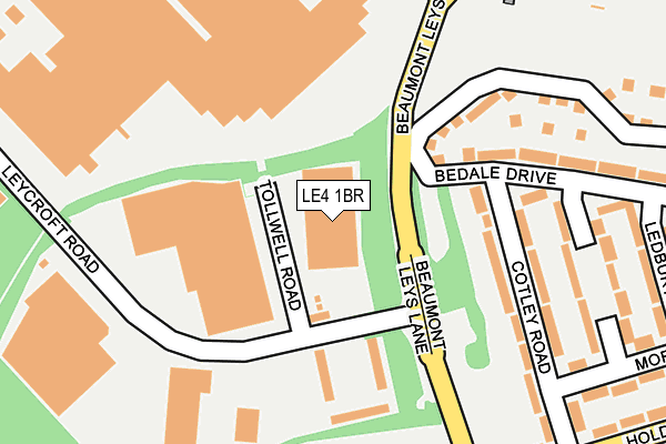
LE4 1BR is located in the Beaumont Leys electoral ward, within the unitary authority of Leicester and the English Parliamentary constituency of Leicester West. The Sub Integrated Care Board (ICB) Location is NHS Leicester, Leicestershire and Rutland ICB - 04C and the police force is Leicestershire. This postcode has been in use since August 1992.


GetTheData
Source: OS OpenMap – Local (Ordnance Survey)
Source: OS VectorMap District (Ordnance Survey)
Licence: Open Government Licence (requires attribution)
| Easting | 457265 |
| Northing | 308333 |
| Latitude | 52.669710 |
| Longitude | -1.154599 |
GetTheData
Source: Open Postcode Geo
Licence: Open Government Licence
| Country | England |
| Postcode District | LE4 |
| ➜ LE4 open data dashboard ➜ See where LE4 is on a map ➜ Where is Leicester? | |
GetTheData
Source: Land Registry Price Paid Data
Licence: Open Government Licence
Elevation or altitude of LE4 1BR as distance above sea level:
| Metres | Feet | |
|---|---|---|
| Elevation | 100m | 328ft |
Elevation is measured from the approximate centre of the postcode, to the nearest point on an OS contour line from OS Terrain 50, which has contour spacing of ten vertical metres.
➜ How high above sea level am I? Find the elevation of your current position using your device's GPS.
GetTheData
Source: Open Postcode Elevation
Licence: Open Government Licence
| Ward | Beaumont Leys |
| Constituency | Leicester West |
GetTheData
Source: ONS Postcode Database
Licence: Open Government Licence
| June 2022 | Anti-social behaviour | On or near Holderness Road | 297m |
| June 2022 | Anti-social behaviour | On or near Holderness Road | 297m |
| June 2022 | Anti-social behaviour | On or near Bedale Drive | 308m |
| ➜ Get more crime data in our Crime section | |||
GetTheData
Source: data.police.uk
Licence: Open Government Licence
| Leycroft Road (Beaumont Leys Lane) | Beaumont Leys | 82m |
| Tolwell Road (Leycroft Road) | Beaumont Leys | 83m |
| Leycroft Road (Beaumont Leys Lane) | Beaumont Leys | 94m |
| Tolwell Road (Leycroft Road) | Beaumont Leys | 96m |
| Madeline Road | Beaumont Leys | 330m |
| Leicester North (Great Central Railway) | Birstall | 1,457m |
| Leicester Station | 4.7km |
| Syston Station | 5.6km |
GetTheData
Source: NaPTAN
Licence: Open Government Licence
GetTheData
Source: ONS Postcode Database
Licence: Open Government Licence


➜ Get more ratings from the Food Standards Agency
GetTheData
Source: Food Standards Agency
Licence: FSA terms & conditions
| Last Collection | |||
|---|---|---|---|
| Location | Mon-Fri | Sat | Distance |
| Stocking Farm Post Office | 17:00 | 12:00 | 839m |
| Grassington Close | 17:30 | 12:00 | 845m |
| Beaumont Leys Post Office | 17:45 | 12:30 | 941m |
GetTheData
Source: Dracos
Licence: Creative Commons Attribution-ShareAlike
| Facility | Distance |
|---|---|
| Mowmacre Hill Primary School Tedworth Green, Leicester Sports Hall, Grass Pitches | 646m |
| Beaumont Lodge Primary School Astill Lodge Road, Beaumount Leys, Leicester Grass Pitches | 667m |
| Leicester Leys Leisure Centre Beaumont Way, Leicester Sports Hall, Swimming Pool, Health and Fitness Gym, Squash Courts, Studio | 836m |
GetTheData
Source: Active Places
Licence: Open Government Licence
| School | Phase of Education | Distance |
|---|---|---|
| Mowmacre Hill Primary School Tedworth Green, Leicester, LE4 2NG | Primary | 646m |
| Beaumont Lodge Primary School Astill Lodge Road, Beaumont Leys, Leicester, LE4 1DT | Primary | 667m |
| Woodstock Primary Academy Hattern Avenue, Leicester, LE4 2GZ | Primary | 972m |
GetTheData
Source: Edubase
Licence: Open Government Licence
The below table lists the International Territorial Level (ITL) codes (formerly Nomenclature of Territorial Units for Statistics (NUTS) codes) and Local Administrative Units (LAU) codes for LE4 1BR:
| ITL 1 Code | Name |
|---|---|
| TLF | East Midlands (England) |
| ITL 2 Code | Name |
| TLF2 | Leicestershire, Rutland and Northamptonshire |
| ITL 3 Code | Name |
| TLF21 | Leicester |
| LAU 1 Code | Name |
| E06000016 | Leicester |
GetTheData
Source: ONS Postcode Directory
Licence: Open Government Licence
The below table lists the Census Output Area (OA), Lower Layer Super Output Area (LSOA), and Middle Layer Super Output Area (MSOA) for LE4 1BR:
| Code | Name | |
|---|---|---|
| OA | E00068763 | |
| LSOA | E01013616 | Leicester 001B |
| MSOA | E02002827 | Leicester 001 |
GetTheData
Source: ONS Postcode Directory
Licence: Open Government Licence
| LE4 2LH | Cotley Road | 198m |
| LE4 2LE | Bedale Drive | 211m |
| LE4 2LB | Bedale Drive | 213m |
| LE4 2LJ | Cotley Road | 221m |
| LE4 1ET | Leycroft Road | 230m |
| LE4 2LF | Cotswold Green | 239m |
| LE4 2LG | Cotswold Green | 278m |
| LE4 2LX | Ledbury Green | 304m |
| LE4 2NE | Morpeth Avenue | 316m |
| LE4 2NB | Morpeth Avenue | 317m |
GetTheData
Source: Open Postcode Geo; Land Registry Price Paid Data
Licence: Open Government Licence