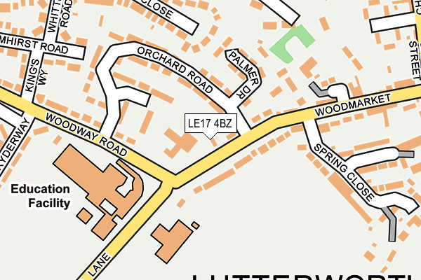
LE17 4BZ lies on Woodmarket in Lutterworth. LE17 4BZ is located in the Lutterworth West electoral ward, within the local authority district of Harborough and the English Parliamentary constituency of South Leicestershire. The Sub Integrated Care Board (ICB) Location is NHS Leicester, Leicestershire and Rutland ICB - 03W and the police force is Leicestershire. This postcode has been in use since January 1980.


GetTheData
Source: OS OpenMap – Local (Ordnance Survey)
Source: OS VectorMap District (Ordnance Survey)
Licence: Open Government Licence (requires attribution)
| Easting | 453983 |
| Northing | 284206 |
| Latitude | 52.453150 |
| Longitude | -1.207054 |
GetTheData
Source: Open Postcode Geo
Licence: Open Government Licence
| Street | Woodmarket |
| Town/City | Lutterworth |
| Country | England |
| Postcode District | LE17 |
| ➜ LE17 open data dashboard ➜ See where LE17 is on a map ➜ Where is Lutterworth? | |
GetTheData
Source: Land Registry Price Paid Data
Licence: Open Government Licence
Elevation or altitude of LE17 4BZ as distance above sea level:
| Metres | Feet | |
|---|---|---|
| Elevation | 120m | 394ft |
Elevation is measured from the approximate centre of the postcode, to the nearest point on an OS contour line from OS Terrain 50, which has contour spacing of ten vertical metres.
➜ How high above sea level am I? Find the elevation of your current position using your device's GPS.
GetTheData
Source: Open Postcode Elevation
Licence: Open Government Licence
| Ward | Lutterworth West |
| Constituency | South Leicestershire |
GetTheData
Source: ONS Postcode Database
Licence: Open Government Licence
2019 9 OCT £415,000 |
2017 25 MAY £344,000 |
1996 8 NOV £55,000 |
GetTheData
Source: HM Land Registry Price Paid Data
Licence: Contains HM Land Registry data © Crown copyright and database right 2024. This data is licensed under the Open Government Licence v3.0.
| June 2023 | Public order | On or near Woodway Road | 326m |
| June 2023 | Other crime | On or near Woodway Road | 326m |
| June 2023 | Violence and sexual offences | On or near Woodway Road | 326m |
| ➜ Woodmarket crime map and outcomes | |||
GetTheData
Source: data.police.uk
Licence: Open Government Licence
| Spring Close (Woodmarket) | Lutterworth | 105m |
| Ryderway (Woodway Road) | Lutterworth | 125m |
| Spring Close (Woodmarket) | Lutterworth | 238m |
| Kingsway (Woodway Road) | Lutterworth | 320m |
| St Mary's Road (Coventry Road) | Lutterworth | 387m |
GetTheData
Source: NaPTAN
Licence: Open Government Licence
| Percentage of properties with Next Generation Access | 100.0% |
| Percentage of properties with Superfast Broadband | 100.0% |
| Percentage of properties with Ultrafast Broadband | 0.0% |
| Percentage of properties with Full Fibre Broadband | 0.0% |
Superfast Broadband is between 30Mbps and 300Mbps
Ultrafast Broadband is > 300Mbps
| Percentage of properties unable to receive 2Mbps | 0.0% |
| Percentage of properties unable to receive 5Mbps | 0.0% |
| Percentage of properties unable to receive 10Mbps | 0.0% |
| Percentage of properties unable to receive 30Mbps | 0.0% |
GetTheData
Source: Ofcom
Licence: Ofcom Terms of Use (requires attribution)
GetTheData
Source: ONS Postcode Database
Licence: Open Government Licence


➜ Get more ratings from the Food Standards Agency
GetTheData
Source: Food Standards Agency
Licence: FSA terms & conditions
| Last Collection | |||
|---|---|---|---|
| Location | Mon-Fri | Sat | Distance |
| Macauley Road | 17:30 | 11:30 | 534m |
| Leicester Road | 17:30 | 11:30 | 1,281m |
| Ashby Parva | 17:00 | 10:30 | 4,338m |
GetTheData
Source: Dracos
Licence: Creative Commons Attribution-ShareAlike
| Facility | Distance |
|---|---|
| Moorbarns Lane Moorbarns Lane, Lutterworth Grass Pitches | 109m |
| John Wycliffe Primary School Moorbarns Lane, Lutterworth Grass Pitches | 141m |
| Lutterworth High School Woodway Road, Lutterworth Sports Hall, Grass Pitches | 171m |
GetTheData
Source: Active Places
Licence: Open Government Licence
| School | Phase of Education | Distance |
|---|---|---|
| John Wycliffe Primary School Moorbarns Lane, Lutterworth, LE17 4QJ | Primary | 146m |
| Lutterworth High School Woodway Road, Lutterworth, LE17 4QH | Secondary | 170m |
| Sherrier Church of England Primary School Bitteswell Road, Lutterworth, LE17 4EX | Primary | 800m |
GetTheData
Source: Edubase
Licence: Open Government Licence
The below table lists the International Territorial Level (ITL) codes (formerly Nomenclature of Territorial Units for Statistics (NUTS) codes) and Local Administrative Units (LAU) codes for LE17 4BZ:
| ITL 1 Code | Name |
|---|---|
| TLF | East Midlands (England) |
| ITL 2 Code | Name |
| TLF2 | Leicestershire, Rutland and Northamptonshire |
| ITL 3 Code | Name |
| TLF22 | Leicestershire CC and Rutland |
| LAU 1 Code | Name |
| E07000131 | Harborough |
GetTheData
Source: ONS Postcode Directory
Licence: Open Government Licence
The below table lists the Census Output Area (OA), Lower Layer Super Output Area (LSOA), and Middle Layer Super Output Area (MSOA) for LE17 4BZ:
| Code | Name | |
|---|---|---|
| OA | E00130858 | |
| LSOA | E01025791 | Harborough 010B |
| MSOA | E02005376 | Harborough 010 |
GetTheData
Source: ONS Postcode Directory
Licence: Open Government Licence
| LE17 4BY | Woodmarket | 55m |
| LE17 4DA | Orchard Road | 122m |
| LE17 4DB | Woodmarket | 175m |
| LE17 4BX | Woodmarket | 175m |
| LE17 4DQ | Wheeler Close | 189m |
| LE17 4QQ | Woodway Road | 195m |
| LE17 4PX | Avery Close | 203m |
| LE17 4PZ | Elmhirst Road | 238m |
| LE17 4PS | St Marys Road | 240m |
| LE17 4DD | Spring Close | 245m |
GetTheData
Source: Open Postcode Geo; Land Registry Price Paid Data
Licence: Open Government Licence