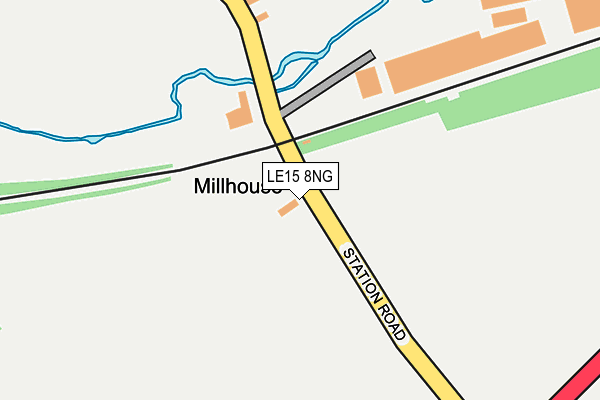
LE15 8NG lies on Station Road in South Luffenham, Oakham. LE15 8NG is located in the Normanton electoral ward, within the unitary authority of Rutland and the English Parliamentary constituency of Rutland and Melton. The Sub Integrated Care Board (ICB) Location is NHS Leicester, Leicestershire and Rutland ICB - 03W and the police force is Leicestershire. This postcode has been in use since January 1980.


GetTheData
Source: OS OpenMap – Local (Ordnance Survey)
Source: OS VectorMap District (Ordnance Survey)
Licence: Open Government Licence (requires attribution)
| Easting | 494543 |
| Northing | 302575 |
| Latitude | 52.612732 |
| Longitude | -0.605132 |
GetTheData
Source: Open Postcode Geo
Licence: Open Government Licence
| Street | Station Road |
| Locality | South Luffenham |
| Town/City | Oakham |
| Country | England |
| Postcode District | LE15 |
| ➜ LE15 open data dashboard ➜ See where LE15 is on a map | |
GetTheData
Source: Land Registry Price Paid Data
Licence: Open Government Licence
Elevation or altitude of LE15 8NG as distance above sea level:
| Metres | Feet | |
|---|---|---|
| Elevation | 50m | 164ft |
Elevation is measured from the approximate centre of the postcode, to the nearest point on an OS contour line from OS Terrain 50, which has contour spacing of ten vertical metres.
➜ How high above sea level am I? Find the elevation of your current position using your device's GPS.
GetTheData
Source: Open Postcode Elevation
Licence: Open Government Licence
| Ward | Normanton |
| Constituency | Rutland And Melton |
GetTheData
Source: ONS Postcode Database
Licence: Open Government Licence
| April 2021 | Vehicle crime | On or near Sports/Recreation Area | 336m |
| April 2021 | Vehicle crime | On or near Sports/Recreation Area | 336m |
| ➜ Get more crime data in our Crime section | |||
GetTheData
Source: data.police.uk
Licence: Open Government Licence
| Level Crossing (Station Road) | South Luffenham | 85m |
| Hall Lane (Stamford Road) | South Luffenham | 721m |
| Cs Ellis (Station Road) | South Luffenham | 757m |
| Hall Lane (Stamford Road) | South Luffenham | 780m |
| The Coach House Inn (Stamford Road) | South Luffenham | 937m |
GetTheData
Source: NaPTAN
Licence: Open Government Licence
| Percentage of properties with Next Generation Access | 100.0% |
| Percentage of properties with Superfast Broadband | 100.0% |
| Percentage of properties with Ultrafast Broadband | 0.0% |
| Percentage of properties with Full Fibre Broadband | 0.0% |
Superfast Broadband is between 30Mbps and 300Mbps
Ultrafast Broadband is > 300Mbps
| Percentage of properties unable to receive 2Mbps | 0.0% |
| Percentage of properties unable to receive 5Mbps | 0.0% |
| Percentage of properties unable to receive 10Mbps | 0.0% |
| Percentage of properties unable to receive 30Mbps | 0.0% |
GetTheData
Source: Ofcom
Licence: Ofcom Terms of Use (requires attribution)
GetTheData
Source: ONS Postcode Database
Licence: Open Government Licence


➜ Get more ratings from the Food Standards Agency
GetTheData
Source: Food Standards Agency
Licence: FSA terms & conditions
| Last Collection | |||
|---|---|---|---|
| Location | Mon-Fri | Sat | Distance |
| Fosters Bridge | 11:30 | 10:30 | 1,570m |
| Burnhams Road | 16:45 | 10:15 | 3,432m |
| Tixover Grange | 16:00 | 09:30 | 3,481m |
GetTheData
Source: Dracos
Licence: Creative Commons Attribution-ShareAlike
| Facility | Distance |
|---|---|
| North Luffenham Cricket Club (The Oval) Pinfold Lane, North Luffenham, Oakham Grass Pitches | 1.4km |
| Luffenham Heath Golf Club Stamford Road, Ketton, Stamford Golf | 1.7km |
| Wakerley And Barrowden Cricket Club Wakerley Road, Barrowden Grass Pitches | 2.1km |
GetTheData
Source: Active Places
Licence: Open Government Licence
| School | Phase of Education | Distance |
|---|---|---|
| St Mary and St John CofE VA Primary School Church Street, North Luffenham, Oakham, Rutland, LE15 8JR | Primary | 1.4km |
| Edith Weston Academy Weston Road, Edith Weston, Oakham, LE15 8HQ | Primary | 3.5km |
| Ketton Church of England Primary School Ketton Cof E Primary School High Street, Ketton, Stamford, PE9 3TE | Primary | 4km |
GetTheData
Source: Edubase
Licence: Open Government Licence
The below table lists the International Territorial Level (ITL) codes (formerly Nomenclature of Territorial Units for Statistics (NUTS) codes) and Local Administrative Units (LAU) codes for LE15 8NG:
| ITL 1 Code | Name |
|---|---|
| TLF | East Midlands (England) |
| ITL 2 Code | Name |
| TLF2 | Leicestershire, Rutland and Northamptonshire |
| ITL 3 Code | Name |
| TLF22 | Leicestershire CC and Rutland |
| LAU 1 Code | Name |
| E06000017 | Rutland |
GetTheData
Source: ONS Postcode Directory
Licence: Open Government Licence
The below table lists the Census Output Area (OA), Lower Layer Super Output Area (LSOA), and Middle Layer Super Output Area (MSOA) for LE15 8NG:
| Code | Name | |
|---|---|---|
| OA | E00069598 | |
| LSOA | E01013797 | Rutland 004C |
| MSOA | E02002866 | Rutland 004 |
GetTheData
Source: ONS Postcode Directory
Licence: Open Government Licence
| LE15 8LF | Station Road | 329m |
| LE15 8NR | Pinfold Lane | 580m |
| LE15 8NE | Pinfold Close | 618m |
| LE15 8NN | Gatehouse Lane | 706m |
| LE15 8NU | Stamford Road | 716m |
| LE15 8NW | Hall Lane | 728m |
| LE15 8NJ | Cutting Lane | 750m |
| LE15 8NX | The Street | 776m |
| LE15 8FE | West Farm Close | 809m |
| LE15 8NP | North Luffenham Road | 819m |
GetTheData
Source: Open Postcode Geo; Land Registry Price Paid Data
Licence: Open Government Licence