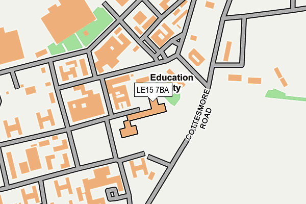
LE15 7BA is located in the Cottesmore electoral ward, within the unitary authority of Rutland and the English Parliamentary constituency of Rutland and Melton. The Sub Integrated Care Board (ICB) Location is NHS Leicester, Leicestershire and Rutland ICB - 03W and the police force is Leicestershire. This postcode has been in use since November 2007.


GetTheData
Source: OS OpenMap – Local (Ordnance Survey)
Source: OS VectorMap District (Ordnance Survey)
Licence: Open Government Licence (requires attribution)
| Easting | 491218 |
| Northing | 315087 |
| Latitude | 52.725747 |
| Longitude | -0.650764 |
GetTheData
Source: Open Postcode Geo
Licence: Open Government Licence
| Country | England |
| Postcode District | LE15 |
| ➜ LE15 open data dashboard ➜ See where LE15 is on a map | |
GetTheData
Source: Land Registry Price Paid Data
Licence: Open Government Licence
Elevation or altitude of LE15 7BA as distance above sea level:
| Metres | Feet | |
|---|---|---|
| Elevation | 130m | 427ft |
Elevation is measured from the approximate centre of the postcode, to the nearest point on an OS contour line from OS Terrain 50, which has contour spacing of ten vertical metres.
➜ How high above sea level am I? Find the elevation of your current position using your device's GPS.
GetTheData
Source: Open Postcode Elevation
Licence: Open Government Licence
| Ward | Cottesmore |
| Constituency | Rutland And Melton |
GetTheData
Source: ONS Postcode Database
Licence: Open Government Licence
| October 2022 | Violence and sexual offences | On or near Bedale Street | 436m |
| May 2022 | Violence and sexual offences | On or near Cotley Crescent | 364m |
| May 2022 | Violence and sexual offences | On or near Cotley Crescent | 364m |
| ➜ Get more crime data in our Crime section | |||
GetTheData
Source: data.police.uk
Licence: Open Government Licence
| Raf Camp (Rogues Lane) | Cottesmore | 445m |
| Main Street (Oakham Road) | Greetham | 1,245m |
| Heath Drive (Rogues Lane) | Cottesmore | 1,385m |
| Toll Bar (Greetham Road) | Cottesmore | 1,529m |
| Toll Barr (Greetham Road) | Cottesmore | 1,548m |
GetTheData
Source: NaPTAN
Licence: Open Government Licence
Estimated total energy consumption in LE15 7BA by fuel type, 2015.
| Consumption (kWh) | 161,232 |
|---|---|
| Meter count | 6 |
| Mean (kWh/meter) | 26,872 |
| Median (kWh/meter) | 33,383 |
GetTheData
Source: Postcode level gas estimates: 2015 (experimental)
Source: Postcode level electricity estimates: 2015 (experimental)
Licence: Open Government Licence
GetTheData
Source: ONS Postcode Database
Licence: Open Government Licence


➜ Get more ratings from the Food Standards Agency
GetTheData
Source: Food Standards Agency
Licence: FSA terms & conditions
| Last Collection | |||
|---|---|---|---|
| Location | Mon-Fri | Sat | Distance |
| High Street | 16:00 | 08:15 | 4,003m |
| Avenue Road | 16:00 | 09:00 | 4,097m |
| Cottesmore Road | 17:00 | 11:00 | 4,764m |
GetTheData
Source: Dracos
Licence: Creative Commons Attribution-ShareAlike
| Facility | Distance |
|---|---|
| Kendrew Barracks Cottesmore, Oakham Artificial Grass Pitch, Grass Pitches, Golf, Sports Hall, Outdoor Tennis Courts | 400m |
| Greetham Community Centre Great Lane, Greetham Sports Hall, Grass Pitches, Outdoor Tennis Courts | 1.6km |
| St Nicholas Ce Primary School Mill Lane, Cottesmore, Oakham Grass Pitches | 1.6km |
GetTheData
Source: Active Places
Licence: Open Government Licence
| School | Phase of Education | Distance |
|---|---|---|
| Cottesmore Academy Kendrew Barracks, Cottesmore, Oakham, LE15 7BA | Primary | 360m |
| St Nicholas Church of England Primary School Mill Lane, Cottesmore, Oakham, LE15 7DL | Primary | 1.7km |
| The Shires Shires Lane, Stretton, LE15 7GT | Not applicable | 3.6km |
GetTheData
Source: Edubase
Licence: Open Government Licence
The below table lists the International Territorial Level (ITL) codes (formerly Nomenclature of Territorial Units for Statistics (NUTS) codes) and Local Administrative Units (LAU) codes for LE15 7BA:
| ITL 1 Code | Name |
|---|---|
| TLF | East Midlands (England) |
| ITL 2 Code | Name |
| TLF2 | Leicestershire, Rutland and Northamptonshire |
| ITL 3 Code | Name |
| TLF22 | Leicestershire CC and Rutland |
| LAU 1 Code | Name |
| E06000017 | Rutland |
GetTheData
Source: ONS Postcode Directory
Licence: Open Government Licence
The below table lists the Census Output Area (OA), Lower Layer Super Output Area (LSOA), and Middle Layer Super Output Area (MSOA) for LE15 7BA:
| Code | Name | |
|---|---|---|
| OA | E00069555 | |
| LSOA | E01013788 | Rutland 001A |
| MSOA | E02002863 | Rutland 001 |
GetTheData
Source: ONS Postcode Directory
Licence: Open Government Licence
| LE15 7BT | Harrier Close | 587m |
| LE15 7NH | Locks Close | 1244m |
| LE15 7NF | Church Lane | 1256m |
| LE15 7NN | Oakham Road | 1267m |
| LE15 7DS | Westland Road | 1288m |
| LE15 7DQ | Long Meadow Way | 1307m |
| LE15 7DT | Westland Road | 1322m |
| LE15 7DF | Heath Drive | 1356m |
| LE15 7NX | Shepherds Lane | 1378m |
| LE15 7DY | Cresswell Drive | 1455m |
GetTheData
Source: Open Postcode Geo; Land Registry Price Paid Data
Licence: Open Government Licence