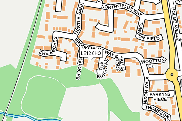
LE12 6HQ is located in the Leake electoral ward, within the local authority district of Rushcliffe and the English Parliamentary constituency of Rushcliffe. The Sub Integrated Care Board (ICB) Location is NHS Nottingham and Nottinghamshire ICB - 52R and the police force is Nottinghamshire. This postcode has been in use since September 2008.


GetTheData
Source: OS OpenMap – Local (Ordnance Survey)
Source: OS VectorMap District (Ordnance Survey)
Licence: Open Government Licence (requires attribution)
| Easting | 455176 |
| Northing | 326888 |
| Latitude | 52.836691 |
| Longitude | -1.182378 |
GetTheData
Source: Open Postcode Geo
Licence: Open Government Licence
| Country | England |
| Postcode District | LE12 |
| ➜ LE12 open data dashboard ➜ See where LE12 is on a map | |
GetTheData
Source: Land Registry Price Paid Data
Licence: Open Government Licence
Elevation or altitude of LE12 6HQ as distance above sea level:
| Metres | Feet | |
|---|---|---|
| Elevation | 50m | 164ft |
Elevation is measured from the approximate centre of the postcode, to the nearest point on an OS contour line from OS Terrain 50, which has contour spacing of ten vertical metres.
➜ How high above sea level am I? Find the elevation of your current position using your device's GPS.
GetTheData
Source: Open Postcode Elevation
Licence: Open Government Licence
| Ward | Leake |
| Constituency | Rushcliffe |
GetTheData
Source: ONS Postcode Database
Licence: Open Government Licence
| June 2022 | Vehicle crime | On or near Northfields Way | 214m |
| June 2022 | Vehicle crime | On or near Hollis Meadow | 239m |
| June 2022 | Violence and sexual offences | On or near Hollis Meadow | 239m |
| ➜ Get more crime data in our Crime section | |||
GetTheData
Source: data.police.uk
Licence: Open Government Licence
| Lantern Lane (Gotham Road) | East Leake | 260m |
| Lantern Lane (Gotham Road) | East Leake | 303m |
| St Marys Crescent (Gotham Road) | East Leake | 382m |
| Stonebridge Drive (Gotham Road) | East Leake | 398m |
| St Marys Crescent (Gotham Road) | East Leake | 407m |
GetTheData
Source: NaPTAN
Licence: Open Government Licence


➜ Get more ratings from the Food Standards Agency
GetTheData
Source: Food Standards Agency
Licence: FSA terms & conditions
| Last Collection | |||
|---|---|---|---|
| Location | Mon-Fri | Sat | Distance |
| St Marys Crescent | 16:15 | 10:00 | 450m |
| Stonebridge Drive | 17:00 | 10:00 | 470m |
| Manor Farm Meadow | 16:00 | 10:30 | 616m |
GetTheData
Source: Dracos
Licence: Creative Commons Attribution-ShareAlike
| Facility | Distance |
|---|---|
| East Leake Leisure Centre Lantern Lane, East Leake, Loughborough Sports Hall, Swimming Pool, Health and Fitness Gym, Artificial Grass Pitch, Grass Pitches, Studio, Outdoor Tennis Courts | 650m |
| Rushcliffe Golf Club Stocking Lane, East Leake, Loughborough Golf | 924m |
| Costock Road Playing Fields Costock Road, East Leake Grass Pitches | 1.1km |
GetTheData
Source: Active Places
Licence: Open Government Licence
| School | Phase of Education | Distance |
|---|---|---|
| Lantern Lane Primary and Nursery School Lantern Lane, East Leake, Loughborough, LE12 6QN | Primary | 574m |
| East Leake Academy Lantern Lane, East Leake, Loughborough, LE12 6QN | Secondary | 670m |
| Brookside Primary School School Green, East Leake, Loughborough, LE12 6LG | Primary | 768m |
GetTheData
Source: Edubase
Licence: Open Government Licence
The below table lists the International Territorial Level (ITL) codes (formerly Nomenclature of Territorial Units for Statistics (NUTS) codes) and Local Administrative Units (LAU) codes for LE12 6HQ:
| ITL 1 Code | Name |
|---|---|
| TLF | East Midlands (England) |
| ITL 2 Code | Name |
| TLF1 | Derbyshire and Nottinghamshire |
| ITL 3 Code | Name |
| TLF16 | South Nottinghamshire |
| LAU 1 Code | Name |
| E07000176 | Rushcliffe |
GetTheData
Source: ONS Postcode Directory
Licence: Open Government Licence
The below table lists the Census Output Area (OA), Lower Layer Super Output Area (LSOA), and Middle Layer Super Output Area (MSOA) for LE12 6HQ:
| Code | Name | |
|---|---|---|
| OA | E00144654 | |
| LSOA | E01028388 | Rushcliffe 015A |
| MSOA | E02005920 | Rushcliffe 015 |
GetTheData
Source: ONS Postcode Directory
Licence: Open Government Licence
| LE12 6HG | The Burrows | 48m |
| LE12 6HH | Brook End | 53m |
| LE12 6HD | Brookfields Way | 61m |
| LE12 6HE | Halls Brook | 101m |
| LE12 6RE | Harefield | 124m |
| LE12 6HJ | The Arches | 130m |
| LE12 6RZ | Northfields Way | 184m |
| LE12 6RY | Towson Field | 195m |
| LE12 6RS | Thistle Bank | 216m |
| LE12 6HF | Wootton Close | 221m |
GetTheData
Source: Open Postcode Geo; Land Registry Price Paid Data
Licence: Open Government Licence