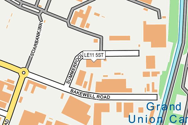
LE11 5ST is located in the Loughborough Storer electoral ward, within the local authority district of Charnwood and the English Parliamentary constituency of Loughborough. The Sub Integrated Care Board (ICB) Location is NHS Leicester, Leicestershire and Rutland ICB - 04V and the police force is Leicestershire. This postcode has been in use since June 2002.


GetTheData
Source: OS OpenMap – Local (Ordnance Survey)
Source: OS VectorMap District (Ordnance Survey)
Licence: Open Government Licence (requires attribution)
| Easting | 452837 |
| Northing | 321336 |
| Latitude | 52.787040 |
| Longitude | -1.217987 |
GetTheData
Source: Open Postcode Geo
Licence: Open Government Licence
| Country | England |
| Postcode District | LE11 |
➜ See where LE11 is on a map ➜ Where is Loughborough? | |
GetTheData
Source: Land Registry Price Paid Data
Licence: Open Government Licence
Elevation or altitude of LE11 5ST as distance above sea level:
| Metres | Feet | |
|---|---|---|
| Elevation | 40m | 131ft |
Elevation is measured from the approximate centre of the postcode, to the nearest point on an OS contour line from OS Terrain 50, which has contour spacing of ten vertical metres.
➜ How high above sea level am I? Find the elevation of your current position using your device's GPS.
GetTheData
Source: Open Postcode Elevation
Licence: Open Government Licence
| Ward | Loughborough Storer |
| Constituency | Loughborough |
GetTheData
Source: ONS Postcode Database
Licence: Open Government Licence
| Astra Zeneca (Bishop Meadow Road) | Loughborough | 458m |
| Messenger Close (Weldon Road) | Loughborough | 629m |
| Derby Road 3m (Derby Road) | Loughborough | 740m |
| Derby Road 3m (Derby Road) | Loughborough | 785m |
| Bishop Meadow Road (Derby Road) | Loughborough | 844m |
| Loughborough (Leics) Station | 1.7km |
| Barrow upon Soar Station | 6.5km |
GetTheData
Source: NaPTAN
Licence: Open Government Licence
GetTheData
Source: ONS Postcode Database
Licence: Open Government Licence


➜ Get more ratings from the Food Standards Agency
GetTheData
Source: Food Standards Agency
Licence: FSA terms & conditions
| Last Collection | |||
|---|---|---|---|
| Location | Mon-Fri | Sat | Distance |
| Weldon Road | 634m | ||
| Derby Road | 17:30 | 10:45 | 856m |
| Warwick Way | 17:30 | 11:45 | 952m |
GetTheData
Source: Dracos
Licence: Creative Commons Attribution-ShareAlike
| Risk of LE11 5ST flooding from rivers and sea | Low |
| ➜ LE11 5ST flood map | |
GetTheData
Source: Open Flood Risk by Postcode
Licence: Open Government Licence
The below table lists the International Territorial Level (ITL) codes (formerly Nomenclature of Territorial Units for Statistics (NUTS) codes) and Local Administrative Units (LAU) codes for LE11 5ST:
| ITL 1 Code | Name |
|---|---|
| TLF | East Midlands (England) |
| ITL 2 Code | Name |
| TLF2 | Leicestershire, Rutland and Northamptonshire |
| ITL 3 Code | Name |
| TLF22 | Leicestershire CC and Rutland |
| LAU 1 Code | Name |
| E07000130 | Charnwood |
GetTheData
Source: ONS Postcode Directory
Licence: Open Government Licence
The below table lists the Census Output Area (OA), Lower Layer Super Output Area (LSOA), and Middle Layer Super Output Area (MSOA) for LE11 5ST:
| Code | Name | |
|---|---|---|
| OA | E00130422 | |
| LSOA | E01025704 | Charnwood 002E |
| MSOA | E02005346 | Charnwood 002 |
GetTheData
Source: ONS Postcode Directory
Licence: Open Government Licence
| LE11 5QY | Bakewell Road | 184m |
| LE11 1QE | Canal Bank | 292m |
| LE11 5QS | Sullivan Way | 296m |
| LE11 5JF | Kernan Drive | 365m |
| LE11 5XJ | Festival Drive | 505m |
| LE11 5TR | Belton Road West | 514m |
| LE11 5RJ | Aerodrome Close | 524m |
| LE11 5DJ | Plumtree Close | 555m |
| LE11 5HX | Kings Avenue | 600m |
| LE11 5XS | Jubilee Drive | 637m |
GetTheData
Source: Open Postcode Geo; Land Registry Price Paid Data
Licence: Open Government Licence