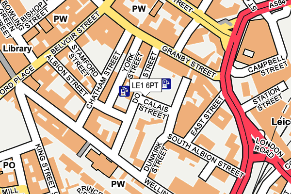
LE1 6PT is located in the Castle electoral ward, within the unitary authority of Leicester and the English Parliamentary constituency of Leicester South. The Sub Integrated Care Board (ICB) Location is NHS Leicester, Leicestershire and Rutland ICB - 04C and the police force is Leicestershire. This postcode has been in use since January 1980.


GetTheData
Source: OS OpenMap – Local (Ordnance Survey)
Source: OS VectorMap District (Ordnance Survey)
Licence: Open Government Licence (requires attribution)
| Easting | 459057 |
| Northing | 304136 |
| Latitude | 52.631792 |
| Longitude | -1.128851 |
GetTheData
Source: Open Postcode Geo
Licence: Open Government Licence
| Country | England |
| Postcode District | LE1 |
| ➜ LE1 open data dashboard ➜ See where LE1 is on a map ➜ Where is Leicester? | |
GetTheData
Source: Land Registry Price Paid Data
Licence: Open Government Licence
Elevation or altitude of LE1 6PT as distance above sea level:
| Metres | Feet | |
|---|---|---|
| Elevation | 70m | 230ft |
Elevation is measured from the approximate centre of the postcode, to the nearest point on an OS contour line from OS Terrain 50, which has contour spacing of ten vertical metres.
➜ How high above sea level am I? Find the elevation of your current position using your device's GPS.
GetTheData
Source: Open Postcode Elevation
Licence: Open Government Licence
| Ward | Castle |
| Constituency | Leicester South |
GetTheData
Source: ONS Postcode Database
Licence: Open Government Licence
| January 2024 | Drugs | On or near Horsefair Street | 357m |
| January 2024 | Possession of weapons | On or near Horsefair Street | 357m |
| January 2024 | Public order | On or near Horsefair Street | 357m |
| ➜ Get more crime data in our Crime section | |||
GetTheData
Source: data.police.uk
Licence: Open Government Licence
| Station Street (Waterloo Way) | Leicester | 191m |
| Charles Street | Leicester | 210m |
| Station Street (London Road) | Leicester | 221m |
| Charles Street | Leicester | 228m |
| Charles Street | Leicester | 229m |
| Leicester Station | 0.2km |
GetTheData
Source: NaPTAN
Licence: Open Government Licence
GetTheData
Source: ONS Postcode Database
Licence: Open Government Licence


➜ Get more ratings from the Food Standards Agency
GetTheData
Source: Food Standards Agency
Licence: FSA terms & conditions
| Last Collection | |||
|---|---|---|---|
| Location | Mon-Fri | Sat | Distance |
| Wellington Street | 18:30 | 12:00 | 132m |
| Campbell Street | 19:00 | 12:00 | 250m |
| London Road (Outside Station) | 18:30 | 12:00 | 254m |
GetTheData
Source: Dracos
Licence: Creative Commons Attribution-ShareAlike
| Facility | Distance |
|---|---|
| The Y East Street, Leicester Sports Hall, Health and Fitness Gym, Studio | 126m |
| Puregym (Leicester St Georges Way) St. Georges Way, Leicester Health and Fitness Gym | 249m |
| Olympia Conditioning Centre (Closed) King Street, Leicester Health and Fitness Gym | 256m |
GetTheData
Source: Active Places
Licence: Open Government Licence
| School | Phase of Education | Distance |
|---|---|---|
| Beauchamp City Sixth Form 1 South Albion Street, Leicester, LE1 6JL | 16 plus | 139m |
| The Children's Hospital School University Hospitals of Leicester NHS Trust, Leicester Royal Infirmary, Leicester, LE1 5WW | Not applicable | 596m |
| Moat Community College Maidstone Road, Leicester, LE2 0TU | Secondary | 628m |
GetTheData
Source: Edubase
Licence: Open Government Licence
The below table lists the International Territorial Level (ITL) codes (formerly Nomenclature of Territorial Units for Statistics (NUTS) codes) and Local Administrative Units (LAU) codes for LE1 6PT:
| ITL 1 Code | Name |
|---|---|
| TLF | East Midlands (England) |
| ITL 2 Code | Name |
| TLF2 | Leicestershire, Rutland and Northamptonshire |
| ITL 3 Code | Name |
| TLF21 | Leicester |
| LAU 1 Code | Name |
| E06000016 | Leicester |
GetTheData
Source: ONS Postcode Directory
Licence: Open Government Licence
The below table lists the Census Output Area (OA), Lower Layer Super Output Area (LSOA), and Middle Layer Super Output Area (MSOA) for LE1 6PT:
| Code | Name | |
|---|---|---|
| OA | E00068903 | |
| LSOA | E01032873 | Leicester 041D |
| MSOA | E02006851 | Leicester 041 |
GetTheData
Source: ONS Postcode Directory
Licence: Open Government Licence
| LE1 6PW | Dover Street | 39m |
| LE1 6PN | Dover Street | 78m |
| LE1 6PP | Dover Street | 78m |
| LE1 6NU | York Street | 80m |
| LE1 6GF | Albion Street | 87m |
| LE1 6FF | Calais Hill | 92m |
| LE1 6PB | Chatham Street | 98m |
| LE1 6HB | Wellington Street | 101m |
| LE1 6NB | East Street | 126m |
| LE1 1DU | Granby Street | 138m |
GetTheData
Source: Open Postcode Geo; Land Registry Price Paid Data
Licence: Open Government Licence