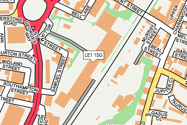
LE1 1SG is located in the Wycliffe electoral ward, within the unitary authority of Leicester and the English Parliamentary constituency of Leicester South. The Sub Integrated Care Board (ICB) Location is NHS Leicester, Leicestershire and Rutland ICB - 04C and the police force is Leicestershire. This postcode has been in use since September 1991.


GetTheData
Source: OS OpenMap – Local (Ordnance Survey)
Source: OS VectorMap District (Ordnance Survey)
Licence: Open Government Licence (requires attribution)
| Easting | 459634 |
| Northing | 304625 |
| Latitude | 52.636124 |
| Longitude | -1.120239 |
GetTheData
Source: Open Postcode Geo
Licence: Open Government Licence
| Country | England |
| Postcode District | LE1 |
| ➜ LE1 open data dashboard ➜ See where LE1 is on a map ➜ Where is Leicester? | |
GetTheData
Source: Land Registry Price Paid Data
Licence: Open Government Licence
Elevation or altitude of LE1 1SG as distance above sea level:
| Metres | Feet | |
|---|---|---|
| Elevation | 60m | 197ft |
Elevation is measured from the approximate centre of the postcode, to the nearest point on an OS contour line from OS Terrain 50, which has contour spacing of ten vertical metres.
➜ How high above sea level am I? Find the elevation of your current position using your device's GPS.
GetTheData
Source: Open Postcode Elevation
Licence: Open Government Licence
| Ward | Wycliffe |
| Constituency | Leicester South |
GetTheData
Source: ONS Postcode Database
Licence: Open Government Licence
| June 2022 | Anti-social behaviour | On or near St George'S Retail Park | 57m |
| June 2022 | Anti-social behaviour | On or near St George'S Retail Park | 57m |
| June 2022 | Possession of weapons | On or near St George'S Retail Park | 57m |
| ➜ Get more crime data in our Crime section | |||
GetTheData
Source: data.police.uk
Licence: Open Government Licence
| Brunswick Street (Humberstone Road) | Leicester | 224m |
| Brunswick Street (Humberstone Road) | Leicester | 237m |
| Madras Road (Humberstone Road) | Leicester | 255m |
| Ann Street (Humberstone Road) | Leicester | 312m |
| Ann Street (Humberstone Road) | Leicester | 317m |
| Leicester Station | 0.6km |
GetTheData
Source: NaPTAN
Licence: Open Government Licence
GetTheData
Source: ONS Postcode Database
Licence: Open Government Licence


➜ Get more ratings from the Food Standards Agency
GetTheData
Source: Food Standards Agency
Licence: FSA terms & conditions
| Last Collection | |||
|---|---|---|---|
| Location | Mon-Fri | Sat | Distance |
| Queen Street | 18:30 | 12:00 | 321m |
| St Matthews Post Office | 17:30 | 12:00 | 368m |
| Hartington Road | 12:00 | 12:00 | 475m |
GetTheData
Source: Dracos
Licence: Creative Commons Attribution-ShareAlike
| Facility | Distance |
|---|---|
| Moat Community College Maidstone Road, Leicester Sports Hall, Artificial Grass Pitch, Studio, Health and Fitness Gym | 355m |
| St Matthews Centre Malabar Road, Leicester Sports Hall | 395m |
| Puregym (Leicester St Georges Way) St. Georges Way, Leicester Health and Fitness Gym | 511m |
GetTheData
Source: Active Places
Licence: Open Government Licence
| School | Phase of Education | Distance |
|---|---|---|
| Moat Community College Maidstone Road, Leicester, LE2 0TU | Secondary | 328m |
| Charnwood Primary School Nedham Street, Leicester, LE2 0HE | Primary | 374m |
| Highfields Primary School Pluto Close, Highfields, Leicester, LE2 0UU | Primary | 491m |
GetTheData
Source: Edubase
Licence: Open Government Licence
The below table lists the International Territorial Level (ITL) codes (formerly Nomenclature of Territorial Units for Statistics (NUTS) codes) and Local Administrative Units (LAU) codes for LE1 1SG:
| ITL 1 Code | Name |
|---|---|
| TLF | East Midlands (England) |
| ITL 2 Code | Name |
| TLF2 | Leicestershire, Rutland and Northamptonshire |
| ITL 3 Code | Name |
| TLF21 | Leicester |
| LAU 1 Code | Name |
| E06000016 | Leicester |
GetTheData
Source: ONS Postcode Directory
Licence: Open Government Licence
The below table lists the Census Output Area (OA), Lower Layer Super Output Area (LSOA), and Middle Layer Super Output Area (MSOA) for LE1 1SG:
| Code | Name | |
|---|---|---|
| OA | E00069357 | |
| LSOA | E01013746 | Leicester 018C |
| MSOA | E02002844 | Leicester 018 |
GetTheData
Source: ONS Postcode Directory
Licence: Open Government Licence
| LE1 1RW | William Street | 133m |
| LE5 3BE | Kent Street | 160m |
| LE5 3BF | Sussex Street | 162m |
| LE2 0AA | Beal Street | 164m |
| LE5 3AN | Humberstone Road | 202m |
| LE2 0BA | Maidstone Road | 212m |
| LE1 1TE | Burton Street | 255m |
| LE2 0UR | Jupiter Close | 262m |
| LE1 1TL | Burton Street | 279m |
| LE2 0AR | Melbourne Street | 284m |
GetTheData
Source: Open Postcode Geo; Land Registry Price Paid Data
Licence: Open Government Licence