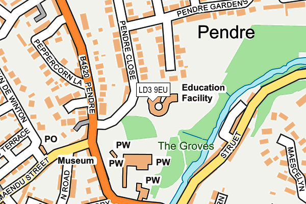
LD3 9EU is located in the Brecon East electoral ward, within the unitary authority of Powys and the Welsh Parliamentary constituency of Brecon and Radnorshire. The Local Health Board is Powys Teaching and the police force is Dyfed-Powys. This postcode has been in use since January 1980.


GetTheData
Source: OS OpenMap – Local (Ordnance Survey)
Source: OS VectorMap District (Ordnance Survey)
Licence: Open Government Licence (requires attribution)
| Easting | 304473 |
| Northing | 229116 |
| Latitude | 51.952302 |
| Longitude | -3.391420 |
GetTheData
Source: Open Postcode Geo
Licence: Open Government Licence
| Country | Wales |
| Postcode District | LD3 |
| ➜ LD3 open data dashboard ➜ See where LD3 is on a map ➜ Where is Brecon? | |
GetTheData
Source: Land Registry Price Paid Data
Licence: Open Government Licence
Elevation or altitude of LD3 9EU as distance above sea level:
| Metres | Feet | |
|---|---|---|
| Elevation | 150m | 492ft |
Elevation is measured from the approximate centre of the postcode, to the nearest point on an OS contour line from OS Terrain 50, which has contour spacing of ten vertical metres.
➜ How high above sea level am I? Find the elevation of your current position using your device's GPS.
GetTheData
Source: Open Postcode Elevation
Licence: Open Government Licence
| Ward | Brecon East |
| Constituency | Brecon And Radnorshire |
GetTheData
Source: ONS Postcode Database
Licence: Open Government Licence
| December 2023 | Violence and sexual offences | On or near Parking Area | 416m |
| August 2023 | Public order | On or near Postern | 282m |
| July 2023 | Anti-social behaviour | On or near Postern | 282m |
| ➜ Get more crime data in our Crime section | |||
GetTheData
Source: data.police.uk
Licence: Open Government Licence
| Cathedral (B4520) | Brecon | 197m |
| Cathedral (B4520 Priory Hill) | Brecon | 197m |
| Pendre Footpath (Pendre Close) | Pendre | 217m |
| Beechgrove (Pendre Gardens) | Pendre | 242m |
| Bryn De Winton | Pendre | 259m |
GetTheData
Source: NaPTAN
Licence: Open Government Licence
GetTheData
Source: ONS Postcode Database
Licence: Open Government Licence


➜ Get more ratings from the Food Standards Agency
GetTheData
Source: Food Standards Agency
Licence: FSA terms & conditions
| Last Collection | |||
|---|---|---|---|
| Location | Mon-Fri | Sat | Distance |
| Bryn De Winton | 16:45 | 11:30 | 236m |
| Struet | 16:45 | 11:45 | 330m |
| Castle Hotel | 16:45 | 11:30 | 401m |
GetTheData
Source: Dracos
Licence: Creative Commons Attribution-ShareAlike
| School | Phase of Education | Distance |
|---|---|---|
| Priory C.I.W. School Pendre Close, Brecon, Powys, LD3 9EU | Not applicable | 17m |
| Mount Street C.P. Junior Brecon, Powys, LD3 7LU | Not applicable | 306m |
| Mount Street C.P. Infants Rhosferig Road, Brecon, Powys, LD3 7NG | Not applicable | 355m |
GetTheData
Source: Edubase
Licence: Open Government Licence
The below table lists the International Territorial Level (ITL) codes (formerly Nomenclature of Territorial Units for Statistics (NUTS) codes) and Local Administrative Units (LAU) codes for LD3 9EU:
| ITL 1 Code | Name |
|---|---|
| TLL | Wales |
| ITL 2 Code | Name |
| TLL2 | East Wales |
| ITL 3 Code | Name |
| TLL24 | Powys |
| LAU 1 Code | Name |
| W06000023 | Powys |
GetTheData
Source: ONS Postcode Directory
Licence: Open Government Licence
The below table lists the Census Output Area (OA), Lower Layer Super Output Area (LSOA), and Middle Layer Super Output Area (MSOA) for LD3 9EU:
| Code | Name | |
|---|---|---|
| OA | W00009777 | |
| LSOA | W01001901 | Powys 017F |
| MSOA | W02000113 | Powys 017 |
GetTheData
Source: ONS Postcode Directory
Licence: Open Government Licence
| LD3 9EW | Pendre Close | 97m |
| LD3 9EB | St Johns Terrace | 156m |
| LD3 7LP | The Struet | 161m |
| LD3 9DW | Priory Hill | 162m |
| LD3 7JW | Honddu Court | 168m |
| LD3 9EF | St Johns Court | 174m |
| LD3 9DN | Priory Hill | 178m |
| LD3 9EP | Pendre Gardens | 180m |
| LD3 7LN | The Struet | 187m |
| LD3 7LW | The Struet | 193m |
GetTheData
Source: Open Postcode Geo; Land Registry Price Paid Data
Licence: Open Government Licence