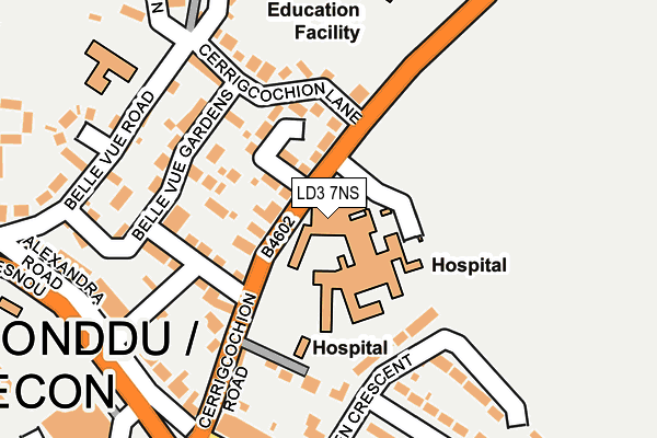
LD3 7NS is located in the Brecon East electoral ward, within the unitary authority of Powys and the Welsh Parliamentary constituency of Brecon and Radnorshire. The Local Health Board is Powys Teaching and the police force is Dyfed-Powys. This postcode has been in use since January 1980.


GetTheData
Source: OS OpenMap – Local (Ordnance Survey)
Source: OS VectorMap District (Ordnance Survey)
Licence: Open Government Licence (requires attribution)
| Easting | 304921 |
| Northing | 228753 |
| Latitude | 51.949116 |
| Longitude | -3.384803 |
GetTheData
Source: Open Postcode Geo
Licence: Open Government Licence
| Country | Wales |
| Postcode District | LD3 |
| ➜ LD3 open data dashboard ➜ See where LD3 is on a map ➜ Where is Brecon? | |
GetTheData
Source: Land Registry Price Paid Data
Licence: Open Government Licence
Elevation or altitude of LD3 7NS as distance above sea level:
| Metres | Feet | |
|---|---|---|
| Elevation | 160m | 525ft |
Elevation is measured from the approximate centre of the postcode, to the nearest point on an OS contour line from OS Terrain 50, which has contour spacing of ten vertical metres.
➜ How high above sea level am I? Find the elevation of your current position using your device's GPS.
GetTheData
Source: Open Postcode Elevation
Licence: Open Government Licence
| Ward | Brecon East |
| Constituency | Brecon And Radnorshire |
GetTheData
Source: ONS Postcode Database
Licence: Open Government Licence
| July 2023 | Anti-social behaviour | On or near Parking Area | 325m |
| June 2023 | Violence and sexual offences | On or near Parking Area | 325m |
| June 2022 | Other theft | On or near Cerrigcochion Lane | 124m |
| ➜ Get more crime data in our Crime section | |||
GetTheData
Source: data.police.uk
Licence: Open Government Licence
| Hospital (Cerrigcochion Road) | Brecon | 33m |
| Hospital (Cerrigcochion Road) | Brecon | 42m |
| Fire Station (Camden Road) | Brecon | 251m |
| Tourist Information Centre (Heol Gouesnou) | Brecon | 273m |
| Interchange (Heol Gouesnou) | Brecon | 281m |
GetTheData
Source: NaPTAN
Licence: Open Government Licence
GetTheData
Source: ONS Postcode Database
Licence: Open Government Licence


➜ Get more ratings from the Food Standards Agency
GetTheData
Source: Food Standards Agency
Licence: FSA terms & conditions
| Last Collection | |||
|---|---|---|---|
| Location | Mon-Fri | Sat | Distance |
| Struet | 16:45 | 11:45 | 438m |
| St Marys Street | 17:15 | 12:15 | 503m |
| Castle Hotel | 16:45 | 11:30 | 649m |
GetTheData
Source: Dracos
Licence: Creative Commons Attribution-ShareAlike
| School | Phase of Education | Distance |
|---|---|---|
| Mount Street C.P. Infants Rhosferig Road, Brecon, Powys, LD3 7NG | Not applicable | 255m |
| Brecon High School Penlan, Brecon, Powys, LD3 9SR | Not applicable | 354m |
| Mount Street C.P. Junior Brecon, Powys, LD3 7LU | Not applicable | 374m |
GetTheData
Source: Edubase
Licence: Open Government Licence
The below table lists the International Territorial Level (ITL) codes (formerly Nomenclature of Territorial Units for Statistics (NUTS) codes) and Local Administrative Units (LAU) codes for LD3 7NS:
| ITL 1 Code | Name |
|---|---|
| TLL | Wales |
| ITL 2 Code | Name |
| TLL2 | East Wales |
| ITL 3 Code | Name |
| TLL24 | Powys |
| LAU 1 Code | Name |
| W06000023 | Powys |
GetTheData
Source: ONS Postcode Directory
Licence: Open Government Licence
The below table lists the Census Output Area (OA), Lower Layer Super Output Area (LSOA), and Middle Layer Super Output Area (MSOA) for LD3 7NS:
| Code | Name | |
|---|---|---|
| OA | W00002630 | |
| LSOA | W01000493 | Powys 017E |
| MSOA | W02000113 | Powys 017 |
GetTheData
Source: ONS Postcode Directory
Licence: Open Government Licence
| LD3 7PG | School Gardens | 70m |
| LD3 7NR | Cerrigcochion Road | 81m |
| LD3 7NP | Cerrigcochion Lane | 131m |
| LD3 7PA | Belle Vue Gardens | 135m |
| LD3 7NT | Cerrigcochion Road | 155m |
| LD3 7NY | Belle Vue Gardens | 157m |
| LD3 7NW | Cerrigcochion Lane | 188m |
| LD3 7NF | Belle Vue Road | 195m |
| LD3 7PB | Alexandra Road | 208m |
| LD3 7BU | Camden Road | 216m |
GetTheData
Source: Open Postcode Geo; Land Registry Price Paid Data
Licence: Open Government Licence