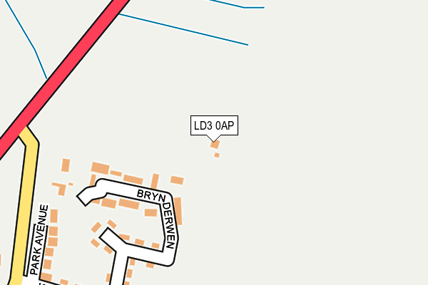
LD3 0AP lies on Hay Road in Talgarth, Brecon. LD3 0AP is located in the Talgarth electoral ward, within the unitary authority of Powys and the Welsh Parliamentary constituency of Brecon and Radnorshire. The Local Health Board is Powys Teaching and the police force is Dyfed-Powys. This postcode has been in use since January 1980.


GetTheData
Source: OS OpenMap – Local (Ordnance Survey)
Source: OS VectorMap District (Ordnance Survey)
Licence: Open Government Licence (requires attribution)
| Easting | 315866 |
| Northing | 234348 |
| Latitude | 52.001173 |
| Longitude | -3.226969 |
GetTheData
Source: Open Postcode Geo
Licence: Open Government Licence
| Street | Hay Road |
| Locality | Talgarth |
| Town/City | Brecon |
| Country | Wales |
| Postcode District | LD3 |
| ➜ LD3 open data dashboard ➜ See where LD3 is on a map ➜ Where is Talgarth? | |
GetTheData
Source: Land Registry Price Paid Data
Licence: Open Government Licence
Elevation or altitude of LD3 0AP as distance above sea level:
| Metres | Feet | |
|---|---|---|
| Elevation | 140m | 459ft |
Elevation is measured from the approximate centre of the postcode, to the nearest point on an OS contour line from OS Terrain 50, which has contour spacing of ten vertical metres.
➜ How high above sea level am I? Find the elevation of your current position using your device's GPS.
GetTheData
Source: Open Postcode Elevation
Licence: Open Government Licence
| Ward | Talgarth |
| Constituency | Brecon And Radnorshire |
GetTheData
Source: ONS Postcode Database
Licence: Open Government Licence
FIR CROFT GARDENS, HAY ROAD, TALGARTH, BRECON, LD3 0AP 2021 11 MAY £405,000 |
FIR CROFT GARDENS, HAY ROAD, TALGARTH, BRECON, LD3 0AP 1997 30 MAY £40,000 |
GetTheData
Source: HM Land Registry Price Paid Data
Licence: Contains HM Land Registry data © Crown copyright and database right 2024. This data is licensed under the Open Government Licence v3.0.
| July 2022 | Violence and sexual offences | On or near Coed-Y-Bryn | 385m |
| May 2022 | Criminal damage and arson | On or near King'S Drive | 299m |
| April 2022 | Violence and sexual offences | On or near Bryn Derwen | 132m |
| ➜ Hay Road crime map and outcomes | |||
GetTheData
Source: data.police.uk
Licence: Open Government Licence
| Post Office (Hay Road) | Talgarth | 673m |
| Post Office (High Street) | Talgarth | 694m |
| Nat West (A479) | Talgarth | 713m |
| Talgarth Road (A479) | Bronllys | 1,470m |
| Talgarth Road (A479) | Bronllys | 1,482m |
GetTheData
Source: NaPTAN
Licence: Open Government Licence
| Percentage of properties with Next Generation Access | 100.0% |
| Percentage of properties with Superfast Broadband | 100.0% |
| Percentage of properties with Ultrafast Broadband | 0.0% |
| Percentage of properties with Full Fibre Broadband | 0.0% |
Superfast Broadband is between 30Mbps and 300Mbps
Ultrafast Broadband is > 300Mbps
| Percentage of properties unable to receive 2Mbps | 0.0% |
| Percentage of properties unable to receive 5Mbps | 0.0% |
| Percentage of properties unable to receive 10Mbps | 0.0% |
| Percentage of properties unable to receive 30Mbps | 0.0% |
GetTheData
Source: Ofcom
Licence: Ofcom Terms of Use (requires attribution)
GetTheData
Source: ONS Postcode Database
Licence: Open Government Licence


➜ Get more ratings from the Food Standards Agency
GetTheData
Source: Food Standards Agency
Licence: FSA terms & conditions
| Last Collection | |||
|---|---|---|---|
| Location | Mon-Fri | Sat | Distance |
| Talgarth Post Office | 16:30 | 11:30 | 679m |
| Bronllys | 16:30 | 11:30 | 1,575m |
| Felindre | 16:00 | 10:30 | 3,487m |
GetTheData
Source: Dracos
Licence: Creative Commons Attribution-ShareAlike
| School | Phase of Education | Distance |
|---|---|---|
| Ysgol y Mynydd Du School Road, Talgarth, LD3 0DQ | Not applicable | 582m |
| Ty Bronllys Trem-Y-Mynydd, Bronllys, Brecon, LD3 0LU | Not applicable | 2.5km |
| Gwernyfed High School Three Cocks, Brecon, Powys, LD3 0SG | Not applicable | 3.4km |
GetTheData
Source: Edubase
Licence: Open Government Licence
The below table lists the International Territorial Level (ITL) codes (formerly Nomenclature of Territorial Units for Statistics (NUTS) codes) and Local Administrative Units (LAU) codes for LD3 0AP:
| ITL 1 Code | Name |
|---|---|
| TLL | Wales |
| ITL 2 Code | Name |
| TLL2 | East Wales |
| ITL 3 Code | Name |
| TLL24 | Powys |
| LAU 1 Code | Name |
| W06000023 | Powys |
GetTheData
Source: ONS Postcode Directory
Licence: Open Government Licence
The below table lists the Census Output Area (OA), Lower Layer Super Output Area (LSOA), and Middle Layer Super Output Area (MSOA) for LD3 0AP:
| Code | Name | |
|---|---|---|
| OA | W00002637 | |
| LSOA | W01000494 | Powys 015E |
| MSOA | W02000111 | Powys 015 |
GetTheData
Source: ONS Postcode Directory
Licence: Open Government Licence
| LD3 0DH | Brynderwen | 146m |
| LD3 0AT | Woodlands Avenue | 199m |
| LD3 0AR | Park Avenue | 258m |
| LD3 0AS | Kings Drive | 304m |
| LD3 0AU | Woodlands Avenue | 342m |
| LD3 0AY | Queens Avenue | 389m |
| LD3 0AN | Hay Road | 424m |
| LD3 0BA | Queens Avenue | 462m |
| LD3 0BD | Churchfields | 478m |
| LD3 0AL | Dan Y Garth | 495m |
GetTheData
Source: Open Postcode Geo; Land Registry Price Paid Data
Licence: Open Government Licence