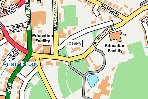
LD1 5HA is located in the Llandrindod South electoral ward, within the unitary authority of Powys and the Welsh Parliamentary constituency of Brecon and Radnorshire. The Local Health Board is Powys Teaching and the police force is Dyfed-Powys. This postcode has been in use since January 1980.


GetTheData
Source: OS OpenMap – Local (Ordnance Survey)
Source: OS VectorMap District (Ordnance Survey)
Licence: Open Government Licence (requires attribution)
| Easting | 306214 |
| Northing | 260972 |
| Latitude | 52.238919 |
| Longitude | -3.374872 |
GetTheData
Source: Open Postcode Geo
Licence: Open Government Licence
| Country | Wales |
| Postcode District | LD1 |
| ➜ LD1 open data dashboard ➜ See where LD1 is on a map ➜ Where is Llandrindod Wells? | |
GetTheData
Source: Land Registry Price Paid Data
Licence: Open Government Licence
Elevation or altitude of LD1 5HA as distance above sea level:
| Metres | Feet | |
|---|---|---|
| Elevation | 220m | 722ft |
Elevation is measured from the approximate centre of the postcode, to the nearest point on an OS contour line from OS Terrain 50, which has contour spacing of ten vertical metres.
➜ How high above sea level am I? Find the elevation of your current position using your device's GPS.
GetTheData
Source: Open Postcode Elevation
Licence: Open Government Licence
| Ward | Llandrindod South |
| Constituency | Brecon And Radnorshire |
GetTheData
Source: ONS Postcode Database
Licence: Open Government Licence
| December 2023 | Violence and sexual offences | On or near Parking Area | 462m |
| November 2023 | Violence and sexual offences | On or near Cefnllys Lane | 445m |
| November 2023 | Violence and sexual offences | On or near Parking Area | 462m |
| ➜ Get more crime data in our Crime section | |||
GetTheData
Source: data.police.uk
Licence: Open Government Licence
| Coleg Powys (Beaufort Road) | Llandrindod Wells | 121m |
| Arlais Day Centre (Beaufort Road) | Llandrindod Wells | 134m |
| Powys County Hall (Grounds) | Llandrindod Wells | 135m |
| Coleg Powys (Spa Road East) | Llandrindod Wells | 147m |
| Doctor's Surgery (Princes Avenue) | Llandrindod Wells | 159m |
| Llandrindod Station | 0.5km |
| Pen-y-Bont Station | 5.3km |
GetTheData
Source: NaPTAN
Licence: Open Government Licence
GetTheData
Source: ONS Postcode Database
Licence: Open Government Licence


➜ Get more ratings from the Food Standards Agency
GetTheData
Source: Food Standards Agency
Licence: FSA terms & conditions
| Last Collection | |||
|---|---|---|---|
| Location | Mon-Fri | Sat | Distance |
| Broadway | 18:15 | 12:00 | 225m |
| Wellfield | 18:15 | 12:00 | 261m |
| Station Crescent Post Office | 19:00 | 13:00 | 380m |
GetTheData
Source: Dracos
Licence: Creative Commons Attribution-ShareAlike
| School | Phase of Education | Distance |
|---|---|---|
| Ysgol Cefnllys Cefnllys Lane, Llandrindod Wells, Powys, LD1 5WA | Not applicable | 624m |
| Ysgol Trefonnen Church In Wales Community Primary Trefonnen Lane, Llandrindod Wells, Powys, LD1 5EP | Not applicable | 802m |
| Crossgates C.P. School Crossgates, Llandrindod Wells, Powys, LD1 6RE | Not applicable | 4.9km |
GetTheData
Source: Edubase
Licence: Open Government Licence
The below table lists the International Territorial Level (ITL) codes (formerly Nomenclature of Territorial Units for Statistics (NUTS) codes) and Local Administrative Units (LAU) codes for LD1 5HA:
| ITL 1 Code | Name |
|---|---|
| TLL | Wales |
| ITL 2 Code | Name |
| TLL2 | East Wales |
| ITL 3 Code | Name |
| TLL24 | Powys |
| LAU 1 Code | Name |
| W06000023 | Powys |
GetTheData
Source: ONS Postcode Directory
Licence: Open Government Licence
The below table lists the Census Output Area (OA), Lower Layer Super Output Area (LSOA), and Middle Layer Super Output Area (MSOA) for LD1 5HA:
| Code | Name | |
|---|---|---|
| OA | W00002431 | |
| LSOA | W01000456 | Powys 013C |
| MSOA | W02000109 | Powys 013 |
GetTheData
Source: ONS Postcode Directory
Licence: Open Government Licence
| LD1 5LD | Cefnllys Lane | 86m |
| LD1 5ES | Spa Road East | 116m |
| LD1 5HU | Princes Avenue | 146m |
| LD1 5DU | Temple Street | 171m |
| LD1 5DP | Temple Street | 207m |
| LD1 5HT | Broadway | 229m |
| LD1 5EE | Beaufort Road | 246m |
| LD1 5HG | Temple Street | 255m |
| LD1 5EY | Spa Road | 276m |
| LD1 5HE | Arlais Road | 279m |
GetTheData
Source: Open Postcode Geo; Land Registry Price Paid Data
Licence: Open Government Licence