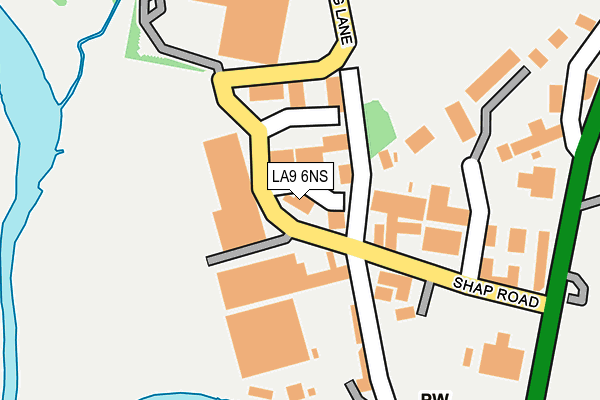
LA9 6NS is located in the Kendal Nether electoral ward, within the unitary authority of Westmorland and Furness and the English Parliamentary constituency of Westmorland and Lonsdale. The Sub Integrated Care Board (ICB) Location is NHS Lancashire and South Cumbria ICB - 01K and the police force is Cumbria. This postcode has been in use since August 1992.


GetTheData
Source: OS OpenMap – Local (Ordnance Survey)
Source: OS VectorMap District (Ordnance Survey)
Licence: Open Government Licence (requires attribution)
| Easting | 351984 |
| Northing | 494653 |
| Latitude | 54.345159 |
| Longitude | -2.740130 |
GetTheData
Source: Open Postcode Geo
Licence: Open Government Licence
| Country | England |
| Postcode District | LA9 |
| ➜ LA9 open data dashboard ➜ See where LA9 is on a map ➜ Where is Kendal? | |
GetTheData
Source: Land Registry Price Paid Data
Licence: Open Government Licence
Elevation or altitude of LA9 6NS as distance above sea level:
| Metres | Feet | |
|---|---|---|
| Elevation | 50m | 164ft |
Elevation is measured from the approximate centre of the postcode, to the nearest point on an OS contour line from OS Terrain 50, which has contour spacing of ten vertical metres.
➜ How high above sea level am I? Find the elevation of your current position using your device's GPS.
GetTheData
Source: Open Postcode Elevation
Licence: Open Government Licence
| Ward | Kendal Nether |
| Constituency | Westmorland And Lonsdale |
GetTheData
Source: ONS Postcode Database
Licence: Open Government Licence
| May 2022 | Criminal damage and arson | On or near Hunters Croft | 335m |
| April 2022 | Violence and sexual offences | On or near Fell View Trading Park | 209m |
| April 2022 | Violence and sexual offences | On or near Fell View Trading Park | 209m |
| ➜ Get more crime data in our Crime section | |||
GetTheData
Source: data.police.uk
Licence: Open Government Licence
| Morrisons (Queen Katherines Avenue) | Mintsfeet | 596m |
| Morrisons (Queen Katherines Avenue) | Mintsfeet | 606m |
| Kent Lea (Burneside Road) | Kendal | 668m |
| Kent Lea (Burneside Road) | Kentrigg | 683m |
| Burneside Road | Kentrigg | 725m |
| Kendal Station | 1.5km |
| Burneside (Cumbria) Station | 2km |
| Oxenholme Lake District Station | 4.6km |
GetTheData
Source: NaPTAN
Licence: Open Government Licence
GetTheData
Source: ONS Postcode Database
Licence: Open Government Licence


➜ Get more ratings from the Food Standards Agency
GetTheData
Source: Food Standards Agency
Licence: FSA terms & conditions
| Last Collection | |||
|---|---|---|---|
| Location | Mon-Fri | Sat | Distance |
| Gillingate | 17:30 | 12:00 | 199m |
| Shap Road Industrial Estate | 17:30 | 210m | |
| Shap Road Industrial Estate | 17:30 | 12:30 | 210m |
GetTheData
Source: Dracos
Licence: Creative Commons Attribution-ShareAlike
| Facility | Distance |
|---|---|
| Mintbridge (Kendal Rufc) Shap Road, Kendal Grass Pitches, Artificial Grass Pitch, Health and Fitness Gym | 399m |
| Kendal Rugby Club (Closed) Shap Road, Kendal Grass Pitches, Health and Fitness Gym, Artificial Grass Pitch | 514m |
| Carus Green Golf Club Burneside Road, Kendal Golf | 625m |
GetTheData
Source: Active Places
Licence: Open Government Licence
| School | Phase of Education | Distance |
|---|---|---|
| The Queen Katherine School Appleby Road, Kendal, LA9 6PJ | Secondary | 709m |
| St Thomas's CofE Primary School Kendal Green, Kendal, LA9 5PP | Primary | 1.2km |
| Sandgate School Sandylands Road, Kendal, LA9 6JG | Not applicable | 1.6km |
GetTheData
Source: Edubase
Licence: Open Government Licence
The below table lists the International Territorial Level (ITL) codes (formerly Nomenclature of Territorial Units for Statistics (NUTS) codes) and Local Administrative Units (LAU) codes for LA9 6NS:
| ITL 1 Code | Name |
|---|---|
| TLD | North West (England) |
| ITL 2 Code | Name |
| TLD1 | Cumbria |
| ITL 3 Code | Name |
| TLD12 | East Cumbria |
| LAU 1 Code | Name |
| E07000031 | South Lakeland |
GetTheData
Source: ONS Postcode Directory
Licence: Open Government Licence
The below table lists the Census Output Area (OA), Lower Layer Super Output Area (LSOA), and Middle Layer Super Output Area (MSOA) for LA9 6NS:
| Code | Name | |
|---|---|---|
| OA | E00097896 | |
| LSOA | E01019365 | South Lakeland 003C |
| MSOA | E02004017 | South Lakeland 003 |
GetTheData
Source: ONS Postcode Directory
Licence: Open Government Licence
| LA9 6NT | Gilthwaiterigg Lane | 105m |
| LA9 6NZ | Shap Road Industrial Estate | 192m |
| LA9 6SB | Hunters Croft | 340m |
| LA9 6NF | Mint Bridge Road | 451m |
| LA9 6NY | Shap Road | 558m |
| LA9 6DU | Queen Katherines Avenue | 562m |
| LA9 6ED | Kent Lea | 611m |
| LA9 6DW | Finley Close | 646m |
| LA9 6EE | Kentrigg | 661m |
| LA9 6DL | Shap Road | 704m |
GetTheData
Source: Open Postcode Geo; Land Registry Price Paid Data
Licence: Open Government Licence