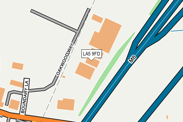
LA5 9FD is located in the Halton-with-Aughton & Kellet electoral ward, within the local authority district of Lancaster and the English Parliamentary constituency of Morecambe and Lunesdale. The Sub Integrated Care Board (ICB) Location is NHS Lancashire and South Cumbria ICB - 01K and the police force is Lancashire. This postcode has been in use since November 2012.


GetTheData
Source: OS OpenMap – Local (Ordnance Survey)
Source: OS VectorMap District (Ordnance Survey)
Licence: Open Government Licence (requires attribution)
| Easting | 350779 |
| Northing | 470307 |
| Latitude | 54.126249 |
| Longitude | -2.754658 |
GetTheData
Source: Open Postcode Geo
Licence: Open Government Licence
| Country | England |
| Postcode District | LA5 |
| ➜ LA5 open data dashboard ➜ See where LA5 is on a map | |
GetTheData
Source: Land Registry Price Paid Data
Licence: Open Government Licence
Elevation or altitude of LA5 9FD as distance above sea level:
| Metres | Feet | |
|---|---|---|
| Elevation | 30m | 98ft |
Elevation is measured from the approximate centre of the postcode, to the nearest point on an OS contour line from OS Terrain 50, which has contour spacing of ten vertical metres.
➜ How high above sea level am I? Find the elevation of your current position using your device's GPS.
GetTheData
Source: Open Postcode Elevation
Licence: Open Government Licence
| Ward | Halton-with-aughton & Kellet |
| Constituency | Morecambe And Lunesdale |
GetTheData
Source: ONS Postcode Database
Licence: Open Government Licence
| June 2022 | Anti-social behaviour | On or near Fairfield Close | 424m |
| June 2022 | Anti-social behaviour | On or near Russell Road | 458m |
| June 2022 | Anti-social behaviour | On or near Russell Road | 458m |
| ➜ Get more crime data in our Crime section | |||
GetTheData
Source: data.police.uk
Licence: Open Government Licence
| Hardknot Rise (Back Lane) | Carnforth | 407m |
| High School (Kellet Road) | Carnforth | 432m |
| Our Lady Of Lourdes (Kellet Road) | Carnforth | 471m |
| Cross Keys (Kellet Road) | Carnforth | 503m |
| Hard Knott Rise (Back Lane) | Carnforth | 512m |
| Carnforth Station | 1.1km |
| Silverdale Station | 5.8km |
GetTheData
Source: NaPTAN
Licence: Open Government Licence
GetTheData
Source: ONS Postcode Database
Licence: Open Government Licence


➜ Get more ratings from the Food Standards Agency
GetTheData
Source: Food Standards Agency
Licence: FSA terms & conditions
| Last Collection | |||
|---|---|---|---|
| Location | Mon-Fri | Sat | Distance |
| Kellet Road | 16:45 | 11:30 | 477m |
| North Road | 16:45 | 10:00 | 585m |
| 25 Coniston Road | 16:30 | 11:30 | 731m |
GetTheData
Source: Dracos
Licence: Creative Commons Attribution-ShareAlike
| Facility | Distance |
|---|---|
| Carnforth Swimming Pool Kellet Road, Carnforth Swimming Pool | 371m |
| Carnforth High School Kellet Road, Carnforth Sports Hall, Grass Pitches, Health and Fitness Gym, Artificial Grass Pitch, Studio | 417m |
| Our Lady Of Lourdes Catholic Primary School Kellet Road, Carnforth Grass Pitches, Sports Hall | 501m |
GetTheData
Source: Active Places
Licence: Open Government Licence
| School | Phase of Education | Distance |
|---|---|---|
| Carnforth High School Kellet Road, Carnforth, LA5 9LS | Secondary | 402m |
| Our Lady of Lourdes Catholic Primary School, Carnforth Kellet Road, Carnforth, LA5 9LS | Primary | 509m |
| Carnforth Christ Church, Church of England, Voluntary Aided Primary School North Road, Carnforth, LA5 9LJ | Primary | 862m |
GetTheData
Source: Edubase
Licence: Open Government Licence
The below table lists the International Territorial Level (ITL) codes (formerly Nomenclature of Territorial Units for Statistics (NUTS) codes) and Local Administrative Units (LAU) codes for LA5 9FD:
| ITL 1 Code | Name |
|---|---|
| TLD | North West (England) |
| ITL 2 Code | Name |
| TLD4 | Lancashire |
| ITL 3 Code | Name |
| TLD44 | Lancaster and Wyre |
| LAU 1 Code | Name |
| E07000121 | Lancaster |
GetTheData
Source: ONS Postcode Directory
Licence: Open Government Licence
The below table lists the Census Output Area (OA), Lower Layer Super Output Area (LSOA), and Middle Layer Super Output Area (MSOA) for LA5 9FD:
| Code | Name | |
|---|---|---|
| OA | E00127541 | |
| LSOA | E01025130 | Lancaster 002A |
| MSOA | E02005222 | Lancaster 002 |
GetTheData
Source: ONS Postcode Directory
Licence: Open Government Licence
| LA5 9XJ | Kellet Road | 412m |
| LA5 9XN | Eden Mount Way | 425m |
| LA5 9XQ | Conder Brow | 446m |
| LA5 9XL | Fairfield Close | 451m |
| LA5 9XH | Whernside Grove | 453m |
| LA5 9XA | Redmayne Drive | 467m |
| LA5 9LS | Kellet Road | 468m |
| LA5 9AQ | Russell Road | 476m |
| LA5 9XF | Arkholme Close | 476m |
| LA5 9BE | Highfield Road | 494m |
GetTheData
Source: Open Postcode Geo; Land Registry Price Paid Data
Licence: Open Government Licence