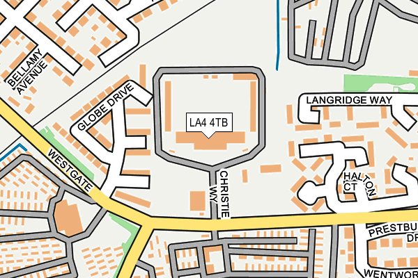
LA4 4TB is located in the Westgate electoral ward, within the local authority district of Lancaster and the English Parliamentary constituency of Morecambe and Lunesdale. The Sub Integrated Care Board (ICB) Location is NHS Lancashire and South Cumbria ICB - 01K and the police force is Lancashire. This postcode has been in use since January 2010.


GetTheData
Source: OS OpenMap – Local (Ordnance Survey)
Source: OS VectorMap District (Ordnance Survey)
Licence: Open Government Licence (requires attribution)
| Easting | 343333 |
| Northing | 463136 |
| Latitude | 54.061050 |
| Longitude | -2.867232 |
GetTheData
Source: Open Postcode Geo
Licence: Open Government Licence
| Country | England |
| Postcode District | LA4 |
| ➜ LA4 open data dashboard ➜ See where LA4 is on a map ➜ Where is Morecambe? | |
GetTheData
Source: Land Registry Price Paid Data
Licence: Open Government Licence
Elevation or altitude of LA4 4TB as distance above sea level:
| Metres | Feet | |
|---|---|---|
| Elevation | 10m | 33ft |
Elevation is measured from the approximate centre of the postcode, to the nearest point on an OS contour line from OS Terrain 50, which has contour spacing of ten vertical metres.
➜ How high above sea level am I? Find the elevation of your current position using your device's GPS.
GetTheData
Source: Open Postcode Elevation
Licence: Open Government Licence
| Ward | Westgate |
| Constituency | Morecambe And Lunesdale |
GetTheData
Source: ONS Postcode Database
Licence: Open Government Licence
| January 2024 | Criminal damage and arson | On or near Thurland Court | 161m |
| December 2023 | Violence and sexual offences | On or near Thurland Court | 161m |
| December 2023 | Criminal damage and arson | On or near Thurland Court | 161m |
| ➜ Get more crime data in our Crime section | |||
GetTheData
Source: data.police.uk
Licence: Open Government Licence
| Morecambe Fc (Westgate) | Westgate | 123m |
| Morecambe Fc (Westgate) | Westgate | 136m |
| Regency Caravan Park (Westgate) | Westgate | 189m |
| Albert Road (Buckingham Road) | West End | 320m |
| Westgate Primary School (Westgate) | Westgate | 330m |
| Morecambe Station | 1km |
| Bare Lane Station | 2.6km |
| Lancaster Station | 4.1km |
GetTheData
Source: NaPTAN
Licence: Open Government Licence
GetTheData
Source: ONS Postcode Database
Licence: Open Government Licence


➜ Get more ratings from the Food Standards Agency
GetTheData
Source: Food Standards Agency
Licence: FSA terms & conditions
| Last Collection | |||
|---|---|---|---|
| Location | Mon-Fri | Sat | Distance |
| Westcliffe Drive | 16:00 | 11:30 | 191m |
| Venture Caravan Park | 16:45 | 11:30 | 380m |
| Westgate | 16:45 | 11:45 | 420m |
GetTheData
Source: Dracos
Licence: Creative Commons Attribution-ShareAlike
| Facility | Distance |
|---|---|
| Morecambe Fc (Mazuma Stadium) Christie Way, Morecambe Artificial Grass Pitch, Grass Pitches | 0m |
| Westgate Primary School Langridge Way, Morecambe Grass Pitches | 387m |
| Morecambe Cricket Club Woodhill Lane, Morecambe Grass Pitches | 417m |
GetTheData
Source: Active Places
Licence: Open Government Licence
| School | Phase of Education | Distance |
|---|---|---|
| Morecambe and Heysham Westgate Primary School Langridge Way, Westgate, Westgate Primary School, Morecambe, LA4 4XF | Primary | 388m |
| Bay Leadership Academy Osborne Road, Morecambe, LA3 1AB | Secondary | 748m |
| West End Primary School Chatsworth Road, Morecambe, LA3 1BW | Primary | 830m |
GetTheData
Source: Edubase
Licence: Open Government Licence
The below table lists the International Territorial Level (ITL) codes (formerly Nomenclature of Territorial Units for Statistics (NUTS) codes) and Local Administrative Units (LAU) codes for LA4 4TB:
| ITL 1 Code | Name |
|---|---|
| TLD | North West (England) |
| ITL 2 Code | Name |
| TLD4 | Lancashire |
| ITL 3 Code | Name |
| TLD44 | Lancaster and Wyre |
| LAU 1 Code | Name |
| E07000121 | Lancaster |
GetTheData
Source: ONS Postcode Directory
Licence: Open Government Licence
The below table lists the Census Output Area (OA), Lower Layer Super Output Area (LSOA), and Middle Layer Super Output Area (MSOA) for LA4 4TB:
| Code | Name | |
|---|---|---|
| OA | E00127759 | |
| LSOA | E01025171 | Lancaster 010B |
| MSOA | E02005230 | Lancaster 010 |
GetTheData
Source: ONS Postcode Directory
Licence: Open Government Licence
| LA4 4XA | Leighton Court | 142m |
| LA4 4PJ | Needham Rise | 201m |
| LA4 4LZ | Fairbank Grove | 206m |
| LA4 4XD | Halton Court | 217m |
| LA4 4UA | Borwick Court | 230m |
| LA4 4LG | Ellesmere Road | 245m |
| LA4 4LY | Ellesmere Grove | 248m |
| LA4 4PQ | Needham Avenue | 254m |
| LA3 3NZ | Wentworth Crescent | 260m |
| LA4 4TN | Aldingham Court | 274m |
GetTheData
Source: Open Postcode Geo; Land Registry Price Paid Data
Licence: Open Government Licence