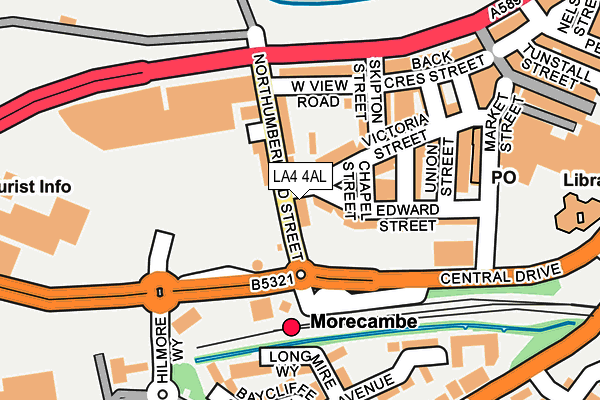
LA4 4AL is located in the Poulton electoral ward, within the local authority district of Lancaster and the English Parliamentary constituency of Morecambe and Lunesdale. The Sub Integrated Care Board (ICB) Location is NHS Lancashire and South Cumbria ICB - 01K and the police force is Lancashire. This postcode has been in use since October 2020.


GetTheData
Source: OS OpenMap – Local (Ordnance Survey)
Source: OS VectorMap District (Ordnance Survey)
Licence: Open Government Licence (requires attribution)
| Easting | 343193 |
| Northing | 464283 |
| Latitude | 54.071342 |
| Longitude | -2.869587 |
GetTheData
Source: Open Postcode Geo
Licence: Open Government Licence
| Country | England |
| Postcode District | LA4 |
| ➜ LA4 open data dashboard ➜ See where LA4 is on a map ➜ Where is Morecambe? | |
GetTheData
Source: Land Registry Price Paid Data
Licence: Open Government Licence
Elevation or altitude of LA4 4AL as distance above sea level:
| Metres | Feet | |
|---|---|---|
| Elevation | 10m | 33ft |
Elevation is measured from the approximate centre of the postcode, to the nearest point on an OS contour line from OS Terrain 50, which has contour spacing of ten vertical metres.
➜ How high above sea level am I? Find the elevation of your current position using your device's GPS.
GetTheData
Source: Open Postcode Elevation
Licence: Open Government Licence
| Ward | Poulton |
| Constituency | Morecambe And Lunesdale |
GetTheData
Source: ONS Postcode Database
Licence: Open Government Licence
| January 2024 | Violence and sexual offences | On or near Parking Area | 42m |
| January 2024 | Anti-social behaviour | On or near Back Crescent Street | 229m |
| January 2024 | Anti-social behaviour | On or near Back Crescent Street | 229m |
| ➜ Get more crime data in our Crime section | |||
GetTheData
Source: data.police.uk
Licence: Open Government Licence
| Bus Station (Central Drive) | Morecambe | 137m |
| Winter Gardens (Marine Road Central) | Morecambe | 164m |
| Eric Morecambe Memorial (Marine Road Central) | Morecambe | 172m |
| Winter Gardens (Marine Road Central) | Morecambe | 189m |
| Eric Morecambe Memorial (Marine Road Central) | Morecambe | 203m |
| Morecambe Station | 0.1km |
| Bare Lane Station | 2.3km |
| Lancaster Station | 4.8km |
GetTheData
Source: NaPTAN
Licence: Open Government Licence
GetTheData
Source: ONS Postcode Database
Licence: Open Government Licence


➜ Get more ratings from the Food Standards Agency
GetTheData
Source: Food Standards Agency
Licence: FSA terms & conditions
| Last Collection | |||
|---|---|---|---|
| Location | Mon-Fri | Sat | Distance |
| Craven Terrace | 16:45 | 12:15 | 139m |
| Morecambe Post Office | 17:30 | 12:00 | 191m |
| Morecambe Post Office | 17:30 | 12:00 | 191m |
GetTheData
Source: Dracos
Licence: Creative Commons Attribution-ShareAlike
| Facility | Distance |
|---|---|
| Concorde Gym And Squash Club (Closed) Victoria Street, Morecambe Squash Courts, Health and Fitness Gym | 143m |
| Everlast Fitness Club (Morecambe) (Closed) Central Drive, Morecambe Health and Fitness Gym, Swimming Pool, Studio | 166m |
| Morecambe Bay Community Primary School Station Road, Morecambe Artificial Grass Pitch | 586m |
GetTheData
Source: Active Places
Licence: Open Government Licence
| School | Phase of Education | Distance |
|---|---|---|
| Morecambe Bay Community Primary School Station Road, Morecambe, LA4 5JL | Primary | 586m |
| Poulton-le-Sands Church of England Primary School Church Street, Morecambe, LA4 5QA | Primary | 818m |
| West End Primary School Chatsworth Road, Morecambe, LA3 1BW | Primary | 967m |
GetTheData
Source: Edubase
Licence: Open Government Licence
The below table lists the International Territorial Level (ITL) codes (formerly Nomenclature of Territorial Units for Statistics (NUTS) codes) and Local Administrative Units (LAU) codes for LA4 4AL:
| ITL 1 Code | Name |
|---|---|
| TLD | North West (England) |
| ITL 2 Code | Name |
| TLD4 | Lancashire |
| ITL 3 Code | Name |
| TLD44 | Lancaster and Wyre |
| LAU 1 Code | Name |
| E07000121 | Lancaster |
GetTheData
Source: ONS Postcode Directory
Licence: Open Government Licence
The below table lists the Census Output Area (OA), Lower Layer Super Output Area (LSOA), and Middle Layer Super Output Area (MSOA) for LA4 4AL:
| Code | Name | |
|---|---|---|
| OA | E00127575 | |
| LSOA | E01025139 | Lancaster 006D |
| MSOA | E02005226 | Lancaster 006 |
GetTheData
Source: ONS Postcode Directory
Licence: Open Government Licence
| LA4 4BA | Northumberland Street | 14m |
| LA4 4AU | Northumberland Street | 52m |
| LA4 4AY | Northumberland Street | 54m |
| LA4 4AF | Victoria Street | 57m |
| LA4 4BL | Edward Street | 84m |
| LA4 4AJ | Victoria Street | 88m |
| LA4 4AR | Skipton Street | 105m |
| LA4 4BW | New Street | 113m |
| LA4 4AS | West View Road | 120m |
| LA4 4BQ | Marine Road Central | 125m |
GetTheData
Source: Open Postcode Geo; Land Registry Price Paid Data
Licence: Open Government Licence