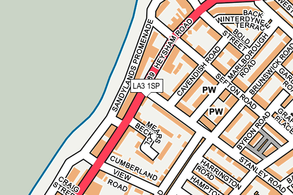
LA3 1SP lies on Stanley Road in Morecambe. LA3 1SP is located in the Heysham North electoral ward, within the local authority district of Lancaster and the English Parliamentary constituency of Morecambe and Lunesdale. The Sub Integrated Care Board (ICB) Location is NHS Lancashire and South Cumbria ICB - 01K and the police force is Lancashire. This postcode has been in use since July 2003.


GetTheData
Source: OS OpenMap – Local (Ordnance Survey)
Source: OS VectorMap District (Ordnance Survey)
Licence: Open Government Licence (requires attribution)
| Easting | 342032 |
| Northing | 463373 |
| Latitude | 54.063024 |
| Longitude | -2.887154 |
GetTheData
Source: Open Postcode Geo
Licence: Open Government Licence
| Street | Stanley Road |
| Town/City | Morecambe |
| Country | England |
| Postcode District | LA3 |
➜ See where LA3 is on a map ➜ Where is Heysham? | |
GetTheData
Source: Land Registry Price Paid Data
Licence: Open Government Licence
Elevation or altitude of LA3 1SP as distance above sea level:
| Metres | Feet | |
|---|---|---|
| Elevation | 10m | 33ft |
Elevation is measured from the approximate centre of the postcode, to the nearest point on an OS contour line from OS Terrain 50, which has contour spacing of ten vertical metres.
➜ How high above sea level am I? Find the elevation of your current position using your device's GPS.
GetTheData
Source: Open Postcode Elevation
Licence: Open Government Licence
| Ward | Heysham North |
| Constituency | Morecambe And Lunesdale |
GetTheData
Source: ONS Postcode Database
Licence: Open Government Licence
| Cavendish Road (Stanley Road) | Sandylands | 10m |
| Stanley Road (Heysham Road) | Sandylands | 24m |
| Stanley Road (Heysham Road) | Sandylands | 30m |
| Cavendish Road (Stanley Road) | Sandylands | 73m |
| Battery (Heysham Road) | Sandylands | 161m |
| Morecambe Station | 1.4km |
| Bare Lane Station | 3.6km |
| Heysham Port Station | 3.7km |
GetTheData
Source: NaPTAN
Licence: Open Government Licence
| Percentage of properties with Next Generation Access | 100.0% |
| Percentage of properties with Superfast Broadband | 100.0% |
| Percentage of properties with Ultrafast Broadband | 100.0% |
| Percentage of properties with Full Fibre Broadband | 0.0% |
Superfast Broadband is between 30Mbps and 300Mbps
Ultrafast Broadband is > 300Mbps
| Percentage of properties unable to receive 2Mbps | 0.0% |
| Percentage of properties unable to receive 5Mbps | 0.0% |
| Percentage of properties unable to receive 10Mbps | 0.0% |
| Percentage of properties unable to receive 30Mbps | 0.0% |
GetTheData
Source: Ofcom
Licence: Ofcom Terms of Use (requires attribution)
GetTheData
Source: ONS Postcode Database
Licence: Open Government Licence


➜ Get more ratings from the Food Standards Agency
GetTheData
Source: Food Standards Agency
Licence: FSA terms & conditions
| Last Collection | |||
|---|---|---|---|
| Location | Mon-Fri | Sat | Distance |
| Sandylands | 16:30 | 11:30 | 75m |
| Battery | 17:00 | 12:15 | 101m |
| 70 Stanley Road | 17:00 | 12:15 | 310m |
GetTheData
Source: Dracos
Licence: Creative Commons Attribution-ShareAlike
| Risk of LA3 1SP flooding from rivers and sea | Low |
| ➜ LA3 1SP flood map | |
GetTheData
Source: Open Flood Risk by Postcode
Licence: Open Government Licence
The below table lists the International Territorial Level (ITL) codes (formerly Nomenclature of Territorial Units for Statistics (NUTS) codes) and Local Administrative Units (LAU) codes for LA3 1SP:
| ITL 1 Code | Name |
|---|---|
| TLD | North West (England) |
| ITL 2 Code | Name |
| TLD4 | Lancashire |
| ITL 3 Code | Name |
| TLD44 | Lancaster and Wyre |
| LAU 1 Code | Name |
| E07000121 | Lancaster |
GetTheData
Source: ONS Postcode Directory
Licence: Open Government Licence
The below table lists the Census Output Area (OA), Lower Layer Super Output Area (LSOA), and Middle Layer Super Output Area (MSOA) for LA3 1SP:
| Code | Name | |
|---|---|---|
| OA | E00127483 | |
| LSOA | E01025120 | Lancaster 009D |
| MSOA | E02005229 | Lancaster 009 |
GetTheData
Source: ONS Postcode Directory
Licence: Open Government Licence
| LA3 1FL | Mears Beck Close | 44m |
| LA3 1FN | Mears Beck Close | 63m |
| LA3 1UP | Stanley Road | 68m |
| LA3 1TX | Cavendish Road | 70m |
| LA3 1DQ | Heysham Road | 77m |
| LA3 1FR | Mears Beck Close | 79m |
| LA3 1FP | Mears Beck Close | 82m |
| LA3 1FS | Mears Beck Close | 92m |
| LA3 1TU | Cavendish Road | 93m |
| LA3 1FT | Mears Beck Close | 110m |
GetTheData
Source: Open Postcode Geo; Land Registry Price Paid Data
Licence: Open Government Licence