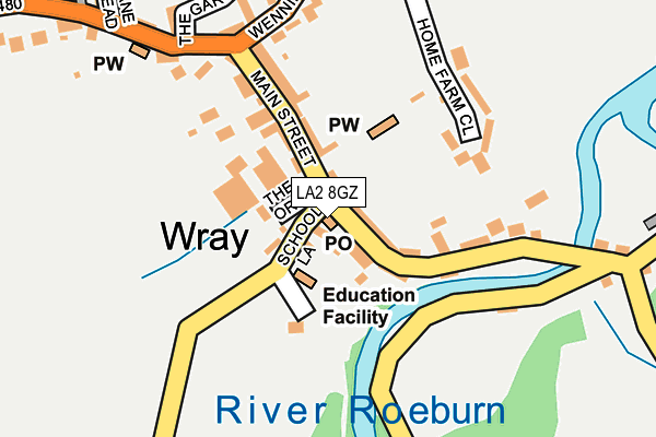
LA2 8GZ is located in the Lower Lune Valley electoral ward, within the local authority district of Lancaster and the English Parliamentary constituency of Lancaster and Fleetwood. The Sub Integrated Care Board (ICB) Location is NHS Lancashire and South Cumbria ICB - 01K and the police force is Lancashire. This postcode has been in use since March 2017.


GetTheData
Source: OS OpenMap – Local (Ordnance Survey)
Source: OS VectorMap District (Ordnance Survey)
Licence: Open Government Licence (requires attribution)
| Easting | 360333 |
| Northing | 467487 |
| Latitude | 54.101745 |
| Longitude | -2.608106 |
GetTheData
Source: Open Postcode Geo
Licence: Open Government Licence
| Country | England |
| Postcode District | LA2 |
| ➜ LA2 open data dashboard ➜ See where LA2 is on a map ➜ Where is Wray? | |
GetTheData
Source: Land Registry Price Paid Data
Licence: Open Government Licence
Elevation or altitude of LA2 8GZ as distance above sea level:
| Metres | Feet | |
|---|---|---|
| Elevation | 60m | 197ft |
Elevation is measured from the approximate centre of the postcode, to the nearest point on an OS contour line from OS Terrain 50, which has contour spacing of ten vertical metres.
➜ How high above sea level am I? Find the elevation of your current position using your device's GPS.
GetTheData
Source: Open Postcode Elevation
Licence: Open Government Licence
| Ward | Lower Lune Valley |
| Constituency | Lancaster And Fleetwood |
GetTheData
Source: ONS Postcode Database
Licence: Open Government Licence
| June 2023 | Criminal damage and arson | On or near The Gars | 235m |
| September 2022 | Anti-social behaviour | On or near The Gars | 235m |
| May 2022 | Anti-social behaviour | On or near Main Street | 133m |
| ➜ Get more crime data in our Crime section | |||
GetTheData
Source: data.police.uk
Licence: Open Government Licence
| Institute (Main Street) | Wray | 117m |
| Bridge End (Main Street) | Wray | 142m |
| George And Dragon (Main Street) | Wray | 150m |
| Bridge End (Main Street) | Wray | 159m |
| Proctors Farm (Wennington Road) | Wray | 190m |
| Wennington Station | 2.8km |
GetTheData
Source: NaPTAN
Licence: Open Government Licence
GetTheData
Source: ONS Postcode Database
Licence: Open Government Licence


➜ Get more ratings from the Food Standards Agency
GetTheData
Source: Food Standards Agency
Licence: FSA terms & conditions
| Last Collection | |||
|---|---|---|---|
| Location | Mon-Fri | Sat | Distance |
| Hornby Post Office | 17:15 | 12:30 | 1,962m |
| Wennington Village | 17:00 | 12:15 | 2,928m |
| Melling Village, Melling | 17:15 | 10:45 | 3,762m |
GetTheData
Source: Dracos
Licence: Creative Commons Attribution-ShareAlike
| Facility | Distance |
|---|---|
| Wray With Botton (Endowed) Primary School School Lane, Wray, Lancaster Grass Pitches | 53m |
| Hornby St Margarets C Of E Primary School Main Street, Hornby, Lancaster Grass Pitches | 2.3km |
| Oneschool Global Uk (Lancaster Campus) Melling Road, Hornby, Lancaster Grass Pitches | 2.5km |
GetTheData
Source: Active Places
Licence: Open Government Licence
| School | Phase of Education | Distance |
|---|---|---|
| Wray with Botton Endowed Primary School School Lane, Wray, Lancaster, LA2 8QE | Primary | 56m |
| Hornby St Margaret's Church of England Primary School Main Street, Hornby, Hornby St. Margaret's Church of England Primary School, Lancaster, LA2 8JY | Primary | 2.3km |
| Oneschool Global Uk Lancaster Campus Melling Road, Hornby, Lancaster, LA2 8LH | Not applicable | 2.5km |
GetTheData
Source: Edubase
Licence: Open Government Licence
The below table lists the International Territorial Level (ITL) codes (formerly Nomenclature of Territorial Units for Statistics (NUTS) codes) and Local Administrative Units (LAU) codes for LA2 8GZ:
| ITL 1 Code | Name |
|---|---|
| TLD | North West (England) |
| ITL 2 Code | Name |
| TLD4 | Lancashire |
| ITL 3 Code | Name |
| TLD44 | Lancaster and Wyre |
| LAU 1 Code | Name |
| E07000121 | Lancaster |
GetTheData
Source: ONS Postcode Directory
Licence: Open Government Licence
The below table lists the Census Output Area (OA), Lower Layer Super Output Area (LSOA), and Middle Layer Super Output Area (MSOA) for LA2 8GZ:
| Code | Name | |
|---|---|---|
| OA | E00127559 | |
| LSOA | E01025132 | Lancaster 002B |
| MSOA | E02005222 | Lancaster 002 |
GetTheData
Source: ONS Postcode Directory
Licence: Open Government Licence
| LA2 8QE | School Lane | 30m |
| LA2 8QD | Main Street | 47m |
| LA2 8RZ | The Orchard | 49m |
| LA2 8QF | Main Street | 78m |
| LA2 8QA | Main Street | 82m |
| LA2 8QB | Main Street | 165m |
| LA2 8QG | Main Street | 167m |
| LA2 8QP | 171m | |
| LA2 8RG | Home Farm Close | 178m |
| LA2 8QQ | Wennington Road | 198m |
GetTheData
Source: Open Postcode Geo; Land Registry Price Paid Data
Licence: Open Government Licence