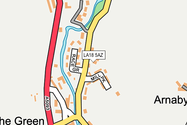
LA18 5AZ lies on Green Hill Road in The Green, Millom. LA18 5AZ is located in the Millom Without electoral ward, within the unitary authority of Cumberland and the English Parliamentary constituency of Copeland. The Sub Integrated Care Board (ICB) Location is NHS Lancashire and South Cumbria ICB - 01K and the police force is Cumbria. This postcode has been in use since January 2008.


GetTheData
Source: OS OpenMap – Local (Ordnance Survey)
Source: OS VectorMap District (Ordnance Survey)
Licence: Open Government Licence (requires attribution)
| Easting | 317973 |
| Northing | 484795 |
| Latitude | 54.252233 |
| Longitude | -3.260492 |
GetTheData
Source: Open Postcode Geo
Licence: Open Government Licence
| Street | Green Hill Road |
| Locality | The Green |
| Town/City | Millom |
| Country | England |
| Postcode District | LA18 |
| ➜ LA18 open data dashboard ➜ See where LA18 is on a map ➜ Where is The Green? | |
GetTheData
Source: Land Registry Price Paid Data
Licence: Open Government Licence
Elevation or altitude of LA18 5AZ as distance above sea level:
| Metres | Feet | |
|---|---|---|
| Elevation | 20m | 66ft |
Elevation is measured from the approximate centre of the postcode, to the nearest point on an OS contour line from OS Terrain 50, which has contour spacing of ten vertical metres.
➜ How high above sea level am I? Find the elevation of your current position using your device's GPS.
GetTheData
Source: Open Postcode Elevation
Licence: Open Government Licence
| Ward | Millom Without |
| Constituency | Copeland |
GetTheData
Source: ONS Postcode Database
Licence: Open Government Licence
| June 2022 | Other theft | On or near Sports/Recreation Area | 248m |
| February 2022 | Violence and sexual offences | On or near Mill Park | 49m |
| December 2021 | Public order | On or near Mill Park | 49m |
| ➜ Get more crime data in our Crime section | |||
GetTheData
Source: data.police.uk
Licence: Open Government Licence
| Village Hall (Green Road) | The Green | 207m |
| Village Hall (Green Road) | The Green | 210m |
| St Annes Church (A595) | Hallthwaites | 732m |
| St Annes Church (A595) | Hallthwaites | 736m |
| Green Road Station | 1.3km |
| Foxfield Station | 3km |
| Millom Station | 4.7km |
GetTheData
Source: NaPTAN
Licence: Open Government Licence
| Percentage of properties with Next Generation Access | 100.0% |
| Percentage of properties with Superfast Broadband | 100.0% |
| Percentage of properties with Ultrafast Broadband | 0.0% |
| Percentage of properties with Full Fibre Broadband | 0.0% |
Superfast Broadband is between 30Mbps and 300Mbps
Ultrafast Broadband is > 300Mbps
| Percentage of properties unable to receive 2Mbps | 0.0% |
| Percentage of properties unable to receive 5Mbps | 0.0% |
| Percentage of properties unable to receive 10Mbps | 0.0% |
| Percentage of properties unable to receive 30Mbps | 0.0% |
GetTheData
Source: Ofcom
Licence: Ofcom Terms of Use (requires attribution)
GetTheData
Source: ONS Postcode Database
Licence: Open Government Licence


➜ Get more ratings from the Food Standards Agency
GetTheData
Source: Food Standards Agency
Licence: FSA terms & conditions
| Last Collection | |||
|---|---|---|---|
| Location | Mon-Fri | Sat | Distance |
| Lady Hall | 12:00 | 10:00 | 1,741m |
| Field View | 16:15 | 11:00 | 1,799m |
| Foxfield Prince Of Wales | 17:45 | 08:15 | 3,083m |
GetTheData
Source: Dracos
Licence: Creative Commons Attribution-ShareAlike
| Facility | Distance |
|---|---|
| Thwaites Village Hall The Green, Millom Sports Hall, Grass Pitches, Outdoor Tennis Courts | 208m |
| Broughton-in-furness Ce School Kepplewray, Broughton-in-furness Grass Pitches | 4.3km |
| Millom School Salthouse Road, Millom Swimming Pool, Artificial Grass Pitch, Grass Pitches, Sports Hall | 4.4km |
GetTheData
Source: Active Places
Licence: Open Government Licence
| School | Phase of Education | Distance |
|---|---|---|
| Thwaites School Hallthwaites, Millom, LA18 5HP | Primary | 670m |
| Broughton CofE Primary and Nursery School Kepplewray, Broughton-in-Furness, LA20 6BJ | Primary | 4.3km |
| Millom School Salthouse Road, Millom, LA18 5AB | Secondary | 4.4km |
GetTheData
Source: Edubase
Licence: Open Government Licence
The below table lists the International Territorial Level (ITL) codes (formerly Nomenclature of Territorial Units for Statistics (NUTS) codes) and Local Administrative Units (LAU) codes for LA18 5AZ:
| ITL 1 Code | Name |
|---|---|
| TLD | North West (England) |
| ITL 2 Code | Name |
| TLD1 | Cumbria |
| ITL 3 Code | Name |
| TLD11 | West Cumbria |
| LAU 1 Code | Name |
| E07000029 | Copeland |
GetTheData
Source: ONS Postcode Directory
Licence: Open Government Licence
The below table lists the Census Output Area (OA), Lower Layer Super Output Area (LSOA), and Middle Layer Super Output Area (MSOA) for LA18 5AZ:
| Code | Name | |
|---|---|---|
| OA | E00097509 | |
| LSOA | E01019293 | Copeland 008E |
| MSOA | E02004007 | Copeland 008 |
GetTheData
Source: ONS Postcode Directory
Licence: Open Government Licence
| LA18 5HW | Mill Park | 56m |
| LA18 5HN | Race Grove | 87m |
| LA18 5HL | 123m | |
| LA18 5GY | Stonebridge Close | 155m |
| LA18 5HJ | 159m | |
| LA18 5HZ | 329m | |
| LA18 5HH | 333m | |
| LA18 5HP | 606m | |
| LA18 5JT | 689m | |
| LA18 5JA | 754m |
GetTheData
Source: Open Postcode Geo; Land Registry Price Paid Data
Licence: Open Government Licence