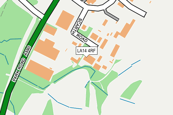
LA14 4RF lies on Scarth Road in Sowerby Woods Industrial Estate, Barrow-in-furness. LA14 4RF is located in the Ormsgill and Parkside electoral ward, within the unitary authority of Westmorland and Furness and the English Parliamentary constituency of Barrow and Furness. The Sub Integrated Care Board (ICB) Location is NHS Lancashire and South Cumbria ICB - 01K and the police force is Cumbria. This postcode has been in use since October 1985.


GetTheData
Source: OS OpenMap – Local (Ordnance Survey)
Source: OS VectorMap District (Ordnance Survey)
Licence: Open Government Licence (requires attribution)
| Easting | 320118 |
| Northing | 473368 |
| Latitude | 54.149906 |
| Longitude | -3.224536 |
GetTheData
Source: Open Postcode Geo
Licence: Open Government Licence
| Street | Scarth Road |
| Locality | Sowerby Woods Industrial Estate |
| Town/City | Barrow-in-furness |
| Country | England |
| Postcode District | LA14 |
| ➜ LA14 open data dashboard ➜ See where LA14 is on a map ➜ Where is Barrow-in-Furness? | |
GetTheData
Source: Land Registry Price Paid Data
Licence: Open Government Licence
Elevation or altitude of LA14 4RF as distance above sea level:
| Metres | Feet | |
|---|---|---|
| Elevation | 40m | 131ft |
Elevation is measured from the approximate centre of the postcode, to the nearest point on an OS contour line from OS Terrain 50, which has contour spacing of ten vertical metres.
➜ How high above sea level am I? Find the elevation of your current position using your device's GPS.
GetTheData
Source: Open Postcode Elevation
Licence: Open Government Licence
| Ward | Ormsgill And Parkside |
| Constituency | Barrow And Furness |
GetTheData
Source: ONS Postcode Database
Licence: Open Government Licence
| June 2022 | Violence and sexual offences | On or near Scarth Road | 136m |
| May 2022 | Burglary | On or near Scarth Road | 136m |
| December 2021 | Violence and sexual offences | On or near Scarth Road | 136m |
| ➜ Scarth Road crime map and outcomes | |||
GetTheData
Source: data.police.uk
Licence: Open Government Licence
| Kimberly Clark (Park Road) | Sowerby | 652m |
| Kimberly Clark (Park Road) | Sowerby | 702m |
| Top Of Sowerby Avenue (Bank Lane) | Ormsgill | 1,001m |
| Top Of Sowerby Avenue (Bank Lane) | Ormsgill | 1,014m |
| Dunmail Raise (Keswick Avenue) | Hawcoat | 1,129m |
| Dalton Station | 3km |
| Barrow-in-Furness Station | 3.4km |
| Roose Station | 4.3km |
GetTheData
Source: NaPTAN
Licence: Open Government Licence
GetTheData
Source: ONS Postcode Database
Licence: Open Government Licence


➜ Get more ratings from the Food Standards Agency
GetTheData
Source: Food Standards Agency
Licence: FSA terms & conditions
| Last Collection | |||
|---|---|---|---|
| Location | Mon-Fri | Sat | Distance |
| Lakes Parade | 17:30 | 11:15 | 1,360m |
| Schneider Road | 17:30 | 10:45 | 2,528m |
| Victoria Avenue | 17:30 | 11:00 | 2,983m |
GetTheData
Source: Dracos
Licence: Creative Commons Attribution-ShareAlike
| Facility | Distance |
|---|---|
| Rakesmoor Lane (Holker Old Boys Fc) Rakesmoor Lane, Barrow-in-furness Grass Pitches | 967m |
| Barrow Golf Club Rakesmoor Lane, Barrow-in-furness Golf | 1km |
| Ormsgill Community Centre Millstone Avenue, Millstone Avenue, Barrow-in-furness Grass Pitches | 1.4km |
GetTheData
Source: Active Places
Licence: Open Government Licence
| School | Phase of Education | Distance |
|---|---|---|
| Dane Ghyll Community Primary School and Nursery Skelwith Drive, Barrow in Furness, LA14 4PG | Primary | 1.5km |
| Ormsgill Nursery and Primary School Mill Bank, Barrow-in-Furness, LA14 4AR | Primary | 1.6km |
| St Pius X Catholic Primary School, Barrow Schneider Road, Barrow-in-Furness, LA14 4AA | Primary | 2.1km |
GetTheData
Source: Edubase
Licence: Open Government Licence
The below table lists the International Territorial Level (ITL) codes (formerly Nomenclature of Territorial Units for Statistics (NUTS) codes) and Local Administrative Units (LAU) codes for LA14 4RF:
| ITL 1 Code | Name |
|---|---|
| TLD | North West (England) |
| ITL 2 Code | Name |
| TLD1 | Cumbria |
| ITL 3 Code | Name |
| TLD11 | West Cumbria |
| LAU 1 Code | Name |
| E07000027 | Barrow-in-Furness |
GetTheData
Source: ONS Postcode Directory
Licence: Open Government Licence
The below table lists the Census Output Area (OA), Lower Layer Super Output Area (LSOA), and Middle Layer Super Output Area (MSOA) for LA14 4RF:
| Code | Name | |
|---|---|---|
| OA | E00096870 | |
| LSOA | E01019164 | Barrow-in-Furness 004C |
| MSOA | E02003980 | Barrow-in-Furness 004 |
GetTheData
Source: ONS Postcode Directory
Licence: Open Government Licence
| LA14 4QS | Park Road | 383m |
| LA14 4LJ | Rakesmoor Lane | 1025m |
| LA14 4DN | Bank Lane | 1026m |
| LA14 4NH | Seatoller Place | 1030m |
| LA14 4DR | Whinsfield Avenue | 1047m |
| LA14 4LH | Bank Lane | 1049m |
| LA14 4DS | Whinsfield Avenue | 1055m |
| LA14 4PU | Helvellyn Walk | 1072m |
| LA14 4DX | Sandscale Terrace | 1084m |
| LA14 4EE | Middle Field | 1091m |
GetTheData
Source: Open Postcode Geo; Land Registry Price Paid Data
Licence: Open Government Licence