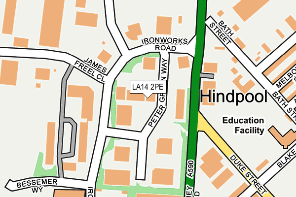
LA14 2PE is located in the Old Barrow and Hindpool electoral ward, within the unitary authority of Westmorland and Furness and the English Parliamentary constituency of Barrow and Furness. The Sub Integrated Care Board (ICB) Location is NHS Lancashire and South Cumbria ICB - 01K and the police force is Cumbria. This postcode has been in use since May 1994.


GetTheData
Source: OS OpenMap – Local (Ordnance Survey)
Source: OS VectorMap District (Ordnance Survey)
Licence: Open Government Licence (requires attribution)
| Easting | 319067 |
| Northing | 469911 |
| Latitude | 54.118671 |
| Longitude | -3.239697 |
GetTheData
Source: Open Postcode Geo
Licence: Open Government Licence
| Country | England |
| Postcode District | LA14 |
| ➜ LA14 open data dashboard ➜ See where LA14 is on a map ➜ Where is Barrow-in-Furness? | |
GetTheData
Source: Land Registry Price Paid Data
Licence: Open Government Licence
Elevation or altitude of LA14 2PE as distance above sea level:
| Metres | Feet | |
|---|---|---|
| Elevation | 20m | 66ft |
Elevation is measured from the approximate centre of the postcode, to the nearest point on an OS contour line from OS Terrain 50, which has contour spacing of ten vertical metres.
➜ How high above sea level am I? Find the elevation of your current position using your device's GPS.
GetTheData
Source: Open Postcode Elevation
Licence: Open Government Licence
| Ward | Old Barrow And Hindpool |
| Constituency | Barrow And Furness |
GetTheData
Source: ONS Postcode Database
Licence: Open Government Licence
| December 2023 | Shoplifting | On or near Supermarket | 419m |
| November 2023 | Shoplifting | On or near Supermarket | 419m |
| November 2023 | Violence and sexual offences | On or near Supermarket | 419m |
| ➜ Get more crime data in our Crime section | |||
GetTheData
Source: data.police.uk
Licence: Open Government Licence
| Oxleys Main Gate (Furness Business Park) | Barrow Ironworks | 93m |
| Furness College (Ironworks Road) | Barrow Ironworks | 144m |
| Furness College (Bessemer Way) | Barrow Ironworks | 324m |
| Holywood Park (Hindpool Road) | Hindpool | 337m |
| Furness College (Ironworks Road) | Barrow Ironworks | 344m |
| Barrow-in-Furness Station | 0.9km |
| Roose Station | 3km |
| Dalton Station | 5.6km |
GetTheData
Source: NaPTAN
Licence: Open Government Licence
| Median download speed | 48.6Mbps |
| Average download speed | 43.2Mbps |
| Maximum download speed | 80.00Mbps |
| Median upload speed | 10.8Mbps |
| Average upload speed | 10.6Mbps |
| Maximum upload speed | 20.00Mbps |
GetTheData
Source: Ofcom
Licence: Ofcom Terms of Use (requires attribution)
Estimated total energy consumption in LA14 2PE by fuel type, 2015.
| Consumption (kWh) | 238,893 |
|---|---|
| Meter count | 8 |
| Mean (kWh/meter) | 29,862 |
| Median (kWh/meter) | 32,415 |
GetTheData
Source: Postcode level gas estimates: 2015 (experimental)
Source: Postcode level electricity estimates: 2015 (experimental)
Licence: Open Government Licence
GetTheData
Source: ONS Postcode Database
Licence: Open Government Licence

➜ Get more ratings from the Food Standards Agency
GetTheData
Source: Food Standards Agency
Licence: FSA terms & conditions
| Last Collection | |||
|---|---|---|---|
| Location | Mon-Fri | Sat | Distance |
| Duke Street Post Office | 17:30 | 12:15 | 801m |
| North Scale, Walney Island | 16:00 | 11:00 | 844m |
| Barrow Delivery Office | 17:30 | 12:30 | 980m |
GetTheData
Source: Dracos
Licence: Creative Commons Attribution-ShareAlike
| Facility | Distance |
|---|---|
| Evolution Gym (Closed) Furness Business Park, Ironworks Road, Barrow-in-furness Health and Fitness Gym | 140m |
| Brisbane Park Blake Street, Barrow-in-furness Grass Pitches | 262m |
| Furness College Campus Channelside, Barrow-in-furness Health and Fitness Gym, Studio, Sports Hall, Artificial Grass Pitch | 285m |
GetTheData
Source: Active Places
Licence: Open Government Licence
| School | Phase of Education | Distance |
|---|---|---|
| Hindpool Nursery School Bath Street, Barrow-in-Furness, LA14 5TS | Nursery | 200m |
| Furness College Channelside, Bessemer Way, Barrow-in-Furness, LA14 2PJ | 16 plus | 278m |
| Brisbane Park Infant School Blake Street, Barrow-in-Furness, LA14 1NY | Primary | 298m |
GetTheData
Source: Edubase
Licence: Open Government Licence
The below table lists the International Territorial Level (ITL) codes (formerly Nomenclature of Territorial Units for Statistics (NUTS) codes) and Local Administrative Units (LAU) codes for LA14 2PE:
| ITL 1 Code | Name |
|---|---|
| TLD | North West (England) |
| ITL 2 Code | Name |
| TLD1 | Cumbria |
| ITL 3 Code | Name |
| TLD11 | West Cumbria |
| LAU 1 Code | Name |
| E07000027 | Barrow-in-Furness |
GetTheData
Source: ONS Postcode Directory
Licence: Open Government Licence
The below table lists the Census Output Area (OA), Lower Layer Super Output Area (LSOA), and Middle Layer Super Output Area (MSOA) for LA14 2PE:
| Code | Name | |
|---|---|---|
| OA | E00096823 | |
| LSOA | E01019156 | Barrow-in-Furness 004A |
| MSOA | E02003980 | Barrow-in-Furness 004 |
GetTheData
Source: ONS Postcode Directory
Licence: Open Government Licence
| LA14 5TR | Bath Street | 193m |
| LA14 2UG | Phoenix Road | 226m |
| LA14 5TS | Bath Street | 250m |
| LA14 5UN | Walney Road | 288m |
| LA14 1YQ | Tay Court | 302m |
| LA14 5TP | Chatsworth Street | 305m |
| LA14 5TU | Melbourne Street | 319m |
| LA14 1XU | Duke Street | 325m |
| LA14 5TT | Melbourne Street | 327m |
| LA14 1NY | Blake Street | 328m |
GetTheData
Source: Open Postcode Geo; Land Registry Price Paid Data
Licence: Open Government Licence