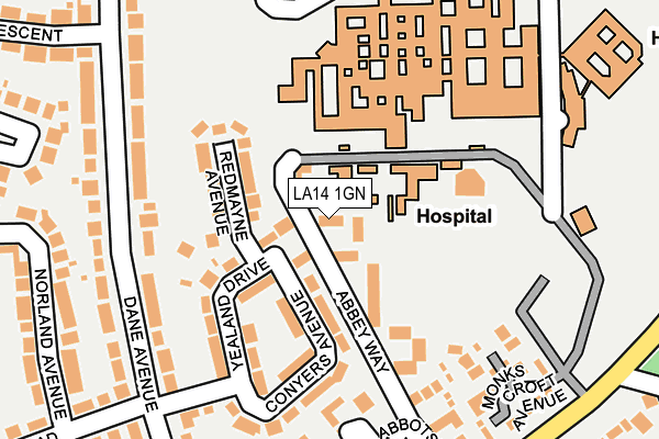
LA14 1GN is located in the Hawcoat and Newbarns electoral ward, within the unitary authority of Westmorland and Furness and the English Parliamentary constituency of Barrow and Furness. The Sub Integrated Care Board (ICB) Location is NHS Lancashire and South Cumbria ICB - 01K and the police force is Cumbria. This postcode has been in use since January 2007.


GetTheData
Source: OS OpenMap – Local (Ordnance Survey)
Source: OS VectorMap District (Ordnance Survey)
Licence: Open Government Licence (requires attribution)
| Easting | 321031 |
| Northing | 471693 |
| Latitude | 54.134989 |
| Longitude | -3.210124 |
GetTheData
Source: Open Postcode Geo
Licence: Open Government Licence
| Country | England |
| Postcode District | LA14 |
| ➜ LA14 open data dashboard ➜ See where LA14 is on a map ➜ Where is Barrow-in-Furness? | |
GetTheData
Source: Land Registry Price Paid Data
Licence: Open Government Licence
Elevation or altitude of LA14 1GN as distance above sea level:
| Metres | Feet | |
|---|---|---|
| Elevation | 50m | 164ft |
Elevation is measured from the approximate centre of the postcode, to the nearest point on an OS contour line from OS Terrain 50, which has contour spacing of ten vertical metres.
➜ How high above sea level am I? Find the elevation of your current position using your device's GPS.
GetTheData
Source: Open Postcode Elevation
Licence: Open Government Licence
| Ward | Hawcoat And Newbarns |
| Constituency | Barrow And Furness |
GetTheData
Source: ONS Postcode Database
Licence: Open Government Licence
| January 2024 | Public order | On or near Hospital | 214m |
| January 2024 | Anti-social behaviour | On or near Hospital | 214m |
| January 2024 | Anti-social behaviour | On or near Hospital | 214m |
| ➜ Get more crime data in our Crime section | |||
GetTheData
Source: data.police.uk
Licence: Open Government Licence
| Furness General Hospital (Hospital Road) | Barrow-in-furness | 205m |
| Dane Avenue | Hawcoat | 216m |
| Hartland Avenue (Dane Avenue) | Hawcoat | 231m |
| Hartland Road (Dane Avenue) | Hawcoat | 243m |
| Portland Crescent (Dane Avenue) | Hawcoat | 244m |
| Barrow-in-Furness Station | 2.1km |
| Roose Station | 2.4km |
| Dalton Station | 3km |
GetTheData
Source: NaPTAN
Licence: Open Government Licence
GetTheData
Source: ONS Postcode Database
Licence: Open Government Licence


➜ Get more ratings from the Food Standards Agency
GetTheData
Source: Food Standards Agency
Licence: FSA terms & conditions
| Last Collection | |||
|---|---|---|---|
| Location | Mon-Fri | Sat | Distance |
| Lakes Parade | 17:30 | 11:15 | 922m |
| Victoria Avenue | 17:30 | 11:00 | 1,367m |
| Schneider Road | 17:30 | 10:45 | 1,614m |
GetTheData
Source: Dracos
Licence: Creative Commons Attribution-ShareAlike
| Facility | Distance |
|---|---|
| Barrow Cricket Club Abbey Road, Barrow-in-furness Grass Pitches | 132m |
| Chetwynde School Rating Lane, Barrow-in-furness Grass Pitches, Sports Hall | 512m |
| Furness College - Sixth Form Campus Rating Lane, Barrow-in-furness Sports Hall, Health and Fitness Gym, Grass Pitches | 654m |
GetTheData
Source: Active Places
Licence: Open Government Licence
| School | Phase of Education | Distance |
|---|---|---|
| Dane Ghyll Community Primary School and Nursery Skelwith Drive, Barrow in Furness, LA14 4PG | Primary | 459m |
| Chetwynde School Rating Lane, Barrow-in-Furness, LA13 0NY | All-through | 513m |
| St Paul's CofE Junior School Hawcoat Lane, Barrow-in-Furness, LA14 4HF | Primary | 618m |
GetTheData
Source: Edubase
Licence: Open Government Licence
The below table lists the International Territorial Level (ITL) codes (formerly Nomenclature of Territorial Units for Statistics (NUTS) codes) and Local Administrative Units (LAU) codes for LA14 1GN:
| ITL 1 Code | Name |
|---|---|
| TLD | North West (England) |
| ITL 2 Code | Name |
| TLD1 | Cumbria |
| ITL 3 Code | Name |
| TLD11 | West Cumbria |
| LAU 1 Code | Name |
| E07000027 | Barrow-in-Furness |
GetTheData
Source: ONS Postcode Directory
Licence: Open Government Licence
The below table lists the Census Output Area (OA), Lower Layer Super Output Area (LSOA), and Middle Layer Super Output Area (MSOA) for LA14 1GN:
| Code | Name | |
|---|---|---|
| OA | E00096808 | |
| LSOA | E01019152 | Barrow-in-Furness 003A |
| MSOA | E02003979 | Barrow-in-Furness 003 |
GetTheData
Source: ONS Postcode Directory
Licence: Open Government Licence
| LA14 4JX | Yealand Drive | 108m |
| LA14 4JU | Redmayne Avenue | 113m |
| LA14 4JT | Conyers Avenue | 130m |
| LA13 9JT | Croslands Villas | 162m |
| LA14 4JY | Dane Avenue | 165m |
| LA14 1EP | Monks Croft Avenue | 211m |
| LA14 1BP | Abbey Way | 213m |
| LA13 9JX | Abbotsfield Gardens | 239m |
| LA14 4ES | Norland Avenue | 256m |
| LA13 9JS | Abbey Road | 258m |
GetTheData
Source: Open Postcode Geo; Land Registry Price Paid Data
Licence: Open Government Licence