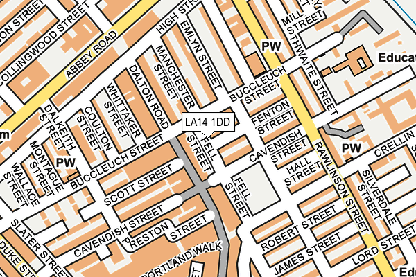
LA14 1DD lies on Fell Street in Barrow-in-furness. LA14 1DD is located in the Old Barrow and Hindpool electoral ward, within the unitary authority of Westmorland and Furness and the English Parliamentary constituency of Barrow and Furness. The Sub Integrated Care Board (ICB) Location is NHS Lancashire and South Cumbria ICB - 01K and the police force is Cumbria. This postcode has been in use since January 1980.


GetTheData
Source: OS OpenMap – Local (Ordnance Survey)
Source: OS VectorMap District (Ordnance Survey)
Licence: Open Government Licence (requires attribution)
| Easting | 319989 |
| Northing | 469436 |
| Latitude | 54.114555 |
| Longitude | -3.225465 |
GetTheData
Source: Open Postcode Geo
Licence: Open Government Licence
| Street | Fell Street |
| Town/City | Barrow-in-furness |
| Country | England |
| Postcode District | LA14 |
| ➜ LA14 open data dashboard ➜ See where LA14 is on a map ➜ Where is Barrow-in-Furness? | |
GetTheData
Source: Land Registry Price Paid Data
Licence: Open Government Licence
Elevation or altitude of LA14 1DD as distance above sea level:
| Metres | Feet | |
|---|---|---|
| Elevation | 10m | 33ft |
Elevation is measured from the approximate centre of the postcode, to the nearest point on an OS contour line from OS Terrain 50, which has contour spacing of ten vertical metres.
➜ How high above sea level am I? Find the elevation of your current position using your device's GPS.
GetTheData
Source: Open Postcode Elevation
Licence: Open Government Licence
| Ward | Old Barrow And Hindpool |
| Constituency | Barrow And Furness |
GetTheData
Source: ONS Postcode Database
Licence: Open Government Licence
| January 2024 | Criminal damage and arson | On or near Parking Area | 29m |
| January 2024 | Public order | On or near Parking Area | 29m |
| January 2024 | Violence and sexual offences | On or near Parking Area | 29m |
| ➜ Fell Street crime map and outcomes | |||
GetTheData
Source: data.police.uk
Licence: Open Government Licence
| The Furness Railway (Abbey Road) | Barrow-in-furness | 221m |
| The Furness Railway (Abbey Road) | Barrow-in-furness | 225m |
| Coronation Gardens (Abbey Road) | Barrow-in-furness | 246m |
| Magistrates Courts (Abbey Road) | Barrow-in-furness | 256m |
| House Of Lords (Abbey Road) | Barrow-in-furness | 313m |
| Barrow-in-Furness Station | 0.5km |
| Roose Station | 2km |
| Dalton Station | 5.4km |
GetTheData
Source: NaPTAN
Licence: Open Government Licence
| Percentage of properties with Next Generation Access | 100.0% |
| Percentage of properties with Superfast Broadband | 100.0% |
| Percentage of properties with Ultrafast Broadband | 0.0% |
| Percentage of properties with Full Fibre Broadband | 0.0% |
Superfast Broadband is between 30Mbps and 300Mbps
Ultrafast Broadband is > 300Mbps
| Percentage of properties unable to receive 2Mbps | 0.0% |
| Percentage of properties unable to receive 5Mbps | 0.0% |
| Percentage of properties unable to receive 10Mbps | 0.0% |
| Percentage of properties unable to receive 30Mbps | 0.0% |
GetTheData
Source: Ofcom
Licence: Ofcom Terms of Use (requires attribution)
GetTheData
Source: ONS Postcode Database
Licence: Open Government Licence


➜ Get more ratings from the Food Standards Agency
GetTheData
Source: Food Standards Agency
Licence: FSA terms & conditions
| Last Collection | |||
|---|---|---|---|
| Location | Mon-Fri | Sat | Distance |
| Town Hall | 18:00 | 11:00 | 297m |
| Barrow Delivery Office | 17:30 | 12:30 | 329m |
| Duke Street Post Office | 17:30 | 12:15 | 343m |
GetTheData
Source: Dracos
Licence: Creative Commons Attribution-ShareAlike
| Facility | Distance |
|---|---|
| D S Fitness Centre Abbey Road, Barrow-in-furness Health and Fitness Gym, Studio | 221m |
| Furness Health Studio (Barrow) (Closed) Greengate Street, Barrow-in-furness Health and Fitness Gym | 362m |
| The Alfred Barrow School (Closed) Duke Street, Barrow-in-furness Sports Hall | 469m |
GetTheData
Source: Active Places
Licence: Open Government Licence
| School | Phase of Education | Distance |
|---|---|---|
| Ramsden Infant School Thwaite Street, Barrow-in-Furness, LA14 1AN | Primary | 222m |
| Greengate Junior School Greengate Street, Barrow-in-Furness, LA14 1BG | Primary | 430m |
| St George's CofE School School Street, Barrow-in-Furness, LA14 2JN | Primary | 739m |
GetTheData
Source: Edubase
Licence: Open Government Licence
The below table lists the International Territorial Level (ITL) codes (formerly Nomenclature of Territorial Units for Statistics (NUTS) codes) and Local Administrative Units (LAU) codes for LA14 1DD:
| ITL 1 Code | Name |
|---|---|
| TLD | North West (England) |
| ITL 2 Code | Name |
| TLD1 | Cumbria |
| ITL 3 Code | Name |
| TLD11 | West Cumbria |
| LAU 1 Code | Name |
| E07000027 | Barrow-in-Furness |
GetTheData
Source: ONS Postcode Directory
Licence: Open Government Licence
The below table lists the Census Output Area (OA), Lower Layer Super Output Area (LSOA), and Middle Layer Super Output Area (MSOA) for LA14 1DD:
| Code | Name | |
|---|---|---|
| OA | E00096822 | |
| LSOA | E01019157 | Barrow-in-Furness 008D |
| MSOA | E02003984 | Barrow-in-Furness 008 |
GetTheData
Source: ONS Postcode Directory
Licence: Open Government Licence
| LA14 1DE | Fenton Street | 29m |
| LA14 1PR | Dalton Road | 31m |
| LA14 1DL | Cavendish Street | 35m |
| LA14 1DA | Buccleuch Street | 50m |
| LA14 1PT | Dalton Road | 65m |
| LA14 1QP | Buccleuch Street | 65m |
| LA14 1DF | Allison Street | 68m |
| LA14 1PX | Dalton Road | 93m |
| LA14 1DG | Fenton Street | 93m |
| LA14 1DJ | Cavendish Street | 97m |
GetTheData
Source: Open Postcode Geo; Land Registry Price Paid Data
Licence: Open Government Licence