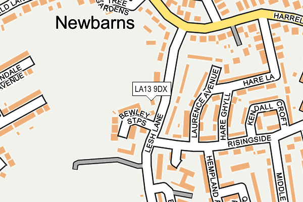
LA13 9DX lies on Bewley Mews in Barrow-in-furness. LA13 9DX is located in the Hawcoat and Newbarns electoral ward, within the unitary authority of Westmorland and Furness and the English Parliamentary constituency of Barrow and Furness. The Sub Integrated Care Board (ICB) Location is NHS Lancashire and South Cumbria ICB - 01K and the police force is Cumbria. This postcode has been in use since June 1998.


GetTheData
Source: OS OpenMap – Local (Ordnance Survey)
Source: OS VectorMap District (Ordnance Survey)
Licence: Open Government Licence (requires attribution)
| Easting | 321062 |
| Northing | 470293 |
| Latitude | 54.122414 |
| Longitude | -3.209283 |
GetTheData
Source: Open Postcode Geo
Licence: Open Government Licence
| Street | Bewley Mews |
| Town/City | Barrow-in-furness |
| Country | England |
| Postcode District | LA13 |
| ➜ LA13 open data dashboard ➜ See where LA13 is on a map ➜ Where is Barrow-in-Furness? | |
GetTheData
Source: Land Registry Price Paid Data
Licence: Open Government Licence
Elevation or altitude of LA13 9DX as distance above sea level:
| Metres | Feet | |
|---|---|---|
| Elevation | 20m | 66ft |
Elevation is measured from the approximate centre of the postcode, to the nearest point on an OS contour line from OS Terrain 50, which has contour spacing of ten vertical metres.
➜ How high above sea level am I? Find the elevation of your current position using your device's GPS.
GetTheData
Source: Open Postcode Elevation
Licence: Open Government Licence
| Ward | Hawcoat And Newbarns |
| Constituency | Barrow And Furness |
GetTheData
Source: ONS Postcode Database
Licence: Open Government Licence
| September 2022 | Other crime | On or near Harrel Lane | 284m |
| June 2022 | Criminal damage and arson | On or near Newbarns Court | 116m |
| June 2022 | Violence and sexual offences | On or near Newbarns Court | 116m |
| ➜ Get more crime data in our Crime section | |||
GetTheData
Source: data.police.uk
Licence: Open Government Licence
| Barrow Wanderers (Lesh Lane) | Newbarns | 90m |
| Laurence Avenue (Risingside) | Newbarns | 96m |
| Furness Academy South (Lesh Lane) | Newbarns | 140m |
| Hollow Lane (Harrel Lane) | Newbarns | 197m |
| Risingside (Middle Hill) | Newbarns | 264m |
| Barrow-in-Furness Station | 1.2km |
| Roose Station | 1.3km |
| Dalton Station | 4.1km |
GetTheData
Source: NaPTAN
Licence: Open Government Licence
| Percentage of properties with Next Generation Access | 100.0% |
| Percentage of properties with Superfast Broadband | 100.0% |
| Percentage of properties with Ultrafast Broadband | 0.0% |
| Percentage of properties with Full Fibre Broadband | 0.0% |
Superfast Broadband is between 30Mbps and 300Mbps
Ultrafast Broadband is > 300Mbps
| Percentage of properties unable to receive 2Mbps | 0.0% |
| Percentage of properties unable to receive 5Mbps | 0.0% |
| Percentage of properties unable to receive 10Mbps | 0.0% |
| Percentage of properties unable to receive 30Mbps | 0.0% |
GetTheData
Source: Ofcom
Licence: Ofcom Terms of Use (requires attribution)
GetTheData
Source: ONS Postcode Database
Licence: Open Government Licence


➜ Get more ratings from the Food Standards Agency
GetTheData
Source: Food Standards Agency
Licence: FSA terms & conditions
| Last Collection | |||
|---|---|---|---|
| Location | Mon-Fri | Sat | Distance |
| Victoria Avenue | 17:30 | 11:00 | 532m |
| Greengate Street | 17:30 | 11:00 | 1,077m |
| Barrow Delivery Office | 17:30 | 12:30 | 1,155m |
GetTheData
Source: Dracos
Licence: Creative Commons Attribution-ShareAlike
| Facility | Distance |
|---|---|
| Barrow Wanderers Football Club Lesh Lane, Barrow-in-furness Grass Pitches | 53m |
| Furness Academy (South Site) (Closed) West Avenue, Barrow-in-furness Sports Hall, Health and Fitness Gym, Grass Pitches | 278m |
| Barrow Island Arlfc Ostley Bank, Barrow-in-furness Grass Pitches, Health and Fitness Gym | 398m |
GetTheData
Source: Active Places
Licence: Open Government Licence
| School | Phase of Education | Distance |
|---|---|---|
| Newbridge House PRU Newbridge House, Ewan Close, Barrow-in-Furness, LA13 9HU | Not applicable | 251m |
| Newbarns Primary and Nursery School Rising Side, Barrow-in-Furness, LA13 9ET | Primary | 322m |
| Holy Family Catholic Primary School Ostley Bank, Newbarns, Barrow-in-Furness, LA13 9LR | Primary | 373m |
GetTheData
Source: Edubase
Licence: Open Government Licence
The below table lists the International Territorial Level (ITL) codes (formerly Nomenclature of Territorial Units for Statistics (NUTS) codes) and Local Administrative Units (LAU) codes for LA13 9DX:
| ITL 1 Code | Name |
|---|---|
| TLD | North West (England) |
| ITL 2 Code | Name |
| TLD1 | Cumbria |
| ITL 3 Code | Name |
| TLD11 | West Cumbria |
| LAU 1 Code | Name |
| E07000027 | Barrow-in-Furness |
GetTheData
Source: ONS Postcode Directory
Licence: Open Government Licence
The below table lists the Census Output Area (OA), Lower Layer Super Output Area (LSOA), and Middle Layer Super Output Area (MSOA) for LA13 9DX:
| Code | Name | |
|---|---|---|
| OA | E00096856 | |
| LSOA | E01019160 | Barrow-in-Furness 007B |
| MSOA | E02003983 | Barrow-in-Furness 007 |
GetTheData
Source: ONS Postcode Directory
Licence: Open Government Licence
| LA13 9EA | Lesh Lane | 53m |
| LA13 9DU | Bewley Steps | 64m |
| LA13 9EH | Laurence Avenue | 75m |
| LA13 9ER | Rising Side | 79m |
| LA13 9DY | Lesh Lane | 105m |
| LA13 9EB | Lesh Lane | 133m |
| LA13 9LX | Yew Tree Walk | 139m |
| LA13 9EJ | Laurence Avenue | 141m |
| LA13 9LW | Hollow Lane | 151m |
| LA13 9EL | Hare Ghyll | 158m |
GetTheData
Source: Open Postcode Geo; Land Registry Price Paid Data
Licence: Open Government Licence