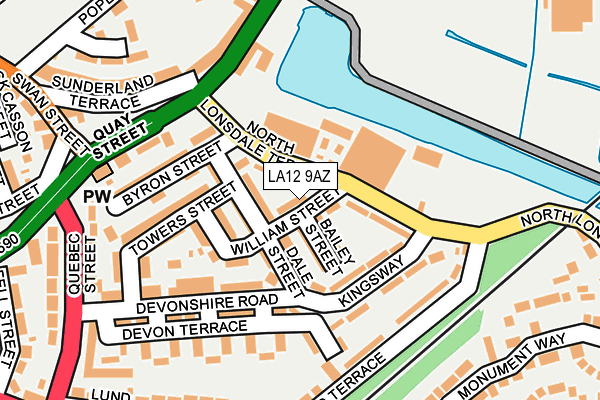
LA12 9AZ lies on William Street in Ulverston. LA12 9AZ is located in the Ulverston electoral ward, within the unitary authority of Westmorland and Furness and the English Parliamentary constituency of Barrow and Furness. The Sub Integrated Care Board (ICB) Location is NHS Lancashire and South Cumbria ICB - 01K and the police force is Cumbria. This postcode has been in use since January 1980.


GetTheData
Source: OS OpenMap – Local (Ordnance Survey)
Source: OS VectorMap District (Ordnance Survey)
Licence: Open Government Licence (requires attribution)
| Easting | 329376 |
| Northing | 478385 |
| Latitude | 54.196347 |
| Longitude | -3.084001 |
GetTheData
Source: Open Postcode Geo
Licence: Open Government Licence
| Street | William Street |
| Town/City | Ulverston |
| Country | England |
| Postcode District | LA12 |
➜ See where LA12 is on a map ➜ Where is Ulverston? | |
GetTheData
Source: Land Registry Price Paid Data
Licence: Open Government Licence
Elevation or altitude of LA12 9AZ as distance above sea level:
| Metres | Feet | |
|---|---|---|
| Elevation | 10m | 33ft |
Elevation is measured from the approximate centre of the postcode, to the nearest point on an OS contour line from OS Terrain 50, which has contour spacing of ten vertical metres.
➜ How high above sea level am I? Find the elevation of your current position using your device's GPS.
GetTheData
Source: Open Postcode Elevation
Licence: Open Government Licence
| Ward | Ulverston |
| Constituency | Barrow And Furness |
GetTheData
Source: ONS Postcode Database
Licence: Open Government Licence
| Kingsway | Ulverston | 113m |
| Booths (Canal Street) | Ulverston | 175m |
| Booths (Canal Street) | Ulverston | 224m |
| Swan Street | Ulverston | 288m |
| Booths (Oubas Hill) | Ulverston | 331m |
| Ulverston Station | 1.1km |
GetTheData
Source: NaPTAN
Licence: Open Government Licence
| Percentage of properties with Next Generation Access | 100.0% |
| Percentage of properties with Superfast Broadband | 100.0% |
| Percentage of properties with Ultrafast Broadband | 0.0% |
| Percentage of properties with Full Fibre Broadband | 0.0% |
Superfast Broadband is between 30Mbps and 300Mbps
Ultrafast Broadband is > 300Mbps
| Median download speed | 30.0Mbps |
| Average download speed | 37.3Mbps |
| Maximum download speed | 79.98Mbps |
| Median upload speed | 4.7Mbps |
| Average upload speed | 7.4Mbps |
| Maximum upload speed | 20.00Mbps |
| Percentage of properties unable to receive 2Mbps | 0.0% |
| Percentage of properties unable to receive 5Mbps | 0.0% |
| Percentage of properties unable to receive 10Mbps | 0.0% |
| Percentage of properties unable to receive 30Mbps | 0.0% |
GetTheData
Source: Ofcom
Licence: Ofcom Terms of Use (requires attribution)
GetTheData
Source: ONS Postcode Database
Licence: Open Government Licence


➜ Get more ratings from the Food Standards Agency
GetTheData
Source: Food Standards Agency
Licence: FSA terms & conditions
| Last Collection | |||
|---|---|---|---|
| Location | Mon-Fri | Sat | Distance |
| Canal Head | 17:30 | 11:30 | 137m |
| 2 Quebec Street | 17:30 | 11:30 | 300m |
| Fell Street | 17:30 | 11:30 | 364m |
GetTheData
Source: Dracos
Licence: Creative Commons Attribution-ShareAlike
| Risk of LA12 9AZ flooding from rivers and sea | High |
| ➜ LA12 9AZ flood map | |
GetTheData
Source: Open Flood Risk by Postcode
Licence: Open Government Licence
The below table lists the International Territorial Level (ITL) codes (formerly Nomenclature of Territorial Units for Statistics (NUTS) codes) and Local Administrative Units (LAU) codes for LA12 9AZ:
| ITL 1 Code | Name |
|---|---|
| TLD | North West (England) |
| ITL 2 Code | Name |
| TLD1 | Cumbria |
| ITL 3 Code | Name |
| TLD12 | East Cumbria |
| LAU 1 Code | Name |
| E07000031 | South Lakeland |
GetTheData
Source: ONS Postcode Directory
Licence: Open Government Licence
The below table lists the Census Output Area (OA), Lower Layer Super Output Area (LSOA), and Middle Layer Super Output Area (MSOA) for LA12 9AZ:
| Code | Name | |
|---|---|---|
| OA | E00098046 | |
| LSOA | E01019389 | South Lakeland 012B |
| MSOA | E02004026 | South Lakeland 012 |
GetTheData
Source: ONS Postcode Directory
Licence: Open Government Licence
| LA12 9AU | North Lonsdale Terrace | 47m |
| LA12 9AY | Bailey Street | 49m |
| LA12 9BA | Dale Street | 60m |
| LA12 9AR | Dale Street | 71m |
| LA12 9AW | Edmondson Street | 86m |
| LA12 9AP | William Street | 92m |
| LA12 9AX | Kingsway | 123m |
| LA12 9AJ | Devonshire Road | 124m |
| LA12 9AS | Byron Street | 140m |
| LA12 9AN | Tower Street | 150m |
GetTheData
Source: Open Postcode Geo; Land Registry Price Paid Data
Licence: Open Government Licence