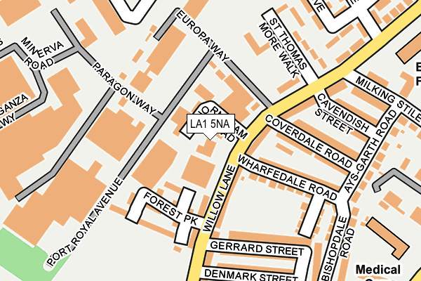
LA1 5NA is located in the Marsh electoral ward, within the local authority district of Lancaster and the English Parliamentary constituency of Lancaster and Fleetwood. The Sub Integrated Care Board (ICB) Location is NHS Lancashire and South Cumbria ICB - 01K and the police force is Lancashire. This postcode has been in use since January 1980.


GetTheData
Source: OS OpenMap – Local (Ordnance Survey)
Source: OS VectorMap District (Ordnance Survey)
Licence: Open Government Licence (requires attribution)
| Easting | 346439 |
| Northing | 461564 |
| Latitude | 54.047255 |
| Longitude | -2.819506 |
GetTheData
Source: Open Postcode Geo
Licence: Open Government Licence
| Country | England |
| Postcode District | LA1 |
➜ See where LA1 is on a map ➜ Where is Lancaster? | |
GetTheData
Source: Land Registry Price Paid Data
Licence: Open Government Licence
Elevation or altitude of LA1 5NA as distance above sea level:
| Metres | Feet | |
|---|---|---|
| Elevation | 10m | 33ft |
Elevation is measured from the approximate centre of the postcode, to the nearest point on an OS contour line from OS Terrain 50, which has contour spacing of ten vertical metres.
➜ How high above sea level am I? Find the elevation of your current position using your device's GPS.
GetTheData
Source: Open Postcode Elevation
Licence: Open Government Licence
| Ward | Marsh |
| Constituency | Lancaster And Fleetwood |
GetTheData
Source: ONS Postcode Database
Licence: Open Government Licence
| Coverdale Road (Willow Lane) | Marsh | 77m |
| Coverdale Road (Willow Lane) | Marsh | 110m |
| Denmark Street (Willow Lane) | Marsh | 201m |
| Denmark Street (Willow Lane) | Marsh | 224m |
| Willow Lane School (Willows Lane) | Marsh | 267m |
| Lancaster Station | 0.8km |
| Bare Lane Station | 3.2km |
| Morecambe Station | 4.1km |
GetTheData
Source: NaPTAN
Licence: Open Government Licence
Estimated total energy consumption in LA1 5NA by fuel type, 2015.
| Consumption (kWh) | 126,991 |
|---|---|
| Meter count | 13 |
| Mean (kWh/meter) | 9,769 |
| Median (kWh/meter) | 8,433 |
GetTheData
Source: Postcode level gas estimates: 2015 (experimental)
Source: Postcode level electricity estimates: 2015 (experimental)
Licence: Open Government Licence
GetTheData
Source: ONS Postcode Database
Licence: Open Government Licence


➜ Get more ratings from the Food Standards Agency
GetTheData
Source: Food Standards Agency
Licence: FSA terms & conditions
| Last Collection | |||
|---|---|---|---|
| Location | Mon-Fri | Sat | Distance |
| Cavendish Street | 16:00 | 12:30 | 172m |
| Coolidge Avenue | 16:00 | 12:30 | 452m |
| Lune Industrial Estate | 17:30 | 12:30 | 508m |
GetTheData
Source: Dracos
Licence: Creative Commons Attribution-ShareAlike
| Risk of LA1 5NA flooding from rivers and sea | Very Low |
| ➜ LA1 5NA flood map | |
GetTheData
Source: Open Flood Risk by Postcode
Licence: Open Government Licence
The below table lists the International Territorial Level (ITL) codes (formerly Nomenclature of Territorial Units for Statistics (NUTS) codes) and Local Administrative Units (LAU) codes for LA1 5NA:
| ITL 1 Code | Name |
|---|---|
| TLD | North West (England) |
| ITL 2 Code | Name |
| TLD4 | Lancashire |
| ITL 3 Code | Name |
| TLD44 | Lancaster and Wyre |
| LAU 1 Code | Name |
| E07000121 | Lancaster |
GetTheData
Source: ONS Postcode Directory
Licence: Open Government Licence
The below table lists the Census Output Area (OA), Lower Layer Super Output Area (LSOA), and Middle Layer Super Output Area (MSOA) for LA1 5NA:
| Code | Name | |
|---|---|---|
| OA | E00127398 | |
| LSOA | E01025100 | Lancaster 017A |
| MSOA | E02005237 | Lancaster 017 |
GetTheData
Source: ONS Postcode Directory
Licence: Open Government Licence
| LA1 5NB | Willow Lane | 69m |
| LA1 5QF | Willow Lane | 80m |
| LA1 5SG | Willow Lane | 86m |
| LA1 5YA | Forest Park | 127m |
| LA1 5ND | Wharfedale Road | 132m |
| LA1 5PX | Willow Lane | 136m |
| LA1 5LZ | Gerrard Street | 161m |
| LA1 5PY | Coverdale Road | 162m |
| LA1 5LP | Willow Lane | 170m |
| LA1 5NE | Kingsdale Road | 190m |
GetTheData
Source: Open Postcode Geo; Land Registry Price Paid Data
Licence: Open Government Licence