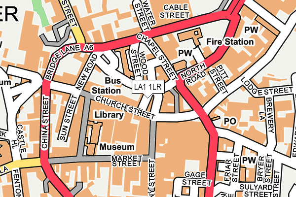
LA1 1LR is located in the Castle electoral ward, within the local authority district of Lancaster and the English Parliamentary constituency of Lancaster and Fleetwood. The Sub Integrated Care Board (ICB) Location is NHS Lancashire and South Cumbria ICB - 01K and the police force is Lancashire. This postcode has been in use since June 1999.


GetTheData
Source: OS OpenMap – Local (Ordnance Survey)
Source: OS VectorMap District (Ordnance Survey)
Licence: Open Government Licence (requires attribution)
| Easting | 347721 |
| Northing | 461835 |
| Latitude | 54.049812 |
| Longitude | -2.799979 |
GetTheData
Source: Open Postcode Geo
Licence: Open Government Licence
| Country | England |
| Postcode District | LA1 |
➜ See where LA1 is on a map ➜ Where is Lancaster? | |
GetTheData
Source: Land Registry Price Paid Data
Licence: Open Government Licence
Elevation or altitude of LA1 1LR as distance above sea level:
| Metres | Feet | |
|---|---|---|
| Elevation | 10m | 33ft |
Elevation is measured from the approximate centre of the postcode, to the nearest point on an OS contour line from OS Terrain 50, which has contour spacing of ten vertical metres.
➜ How high above sea level am I? Find the elevation of your current position using your device's GPS.
GetTheData
Source: Open Postcode Elevation
Licence: Open Government Licence
| Ward | Castle |
| Constituency | Lancaster And Fleetwood |
GetTheData
Source: ONS Postcode Database
Licence: Open Government Licence
| Chapel Street | Lancaster City Centre | 80m |
| China Street | Lancaster City Centre | 226m |
| Waring And Gillow (North Road) | Lancaster City Centre | 229m |
| Dalton Square | Lancaster City Centre | 236m |
| Common Garden Street | Lancaster City Centre | 258m |
| Lancaster Station | 0.5km |
| Bare Lane Station | 3.6km |
| Morecambe Station | 5.1km |
GetTheData
Source: NaPTAN
Licence: Open Government Licence
| Percentage of properties with Next Generation Access | 100.0% |
| Percentage of properties with Superfast Broadband | 100.0% |
| Percentage of properties with Ultrafast Broadband | 0.0% |
| Percentage of properties with Full Fibre Broadband | 0.0% |
Superfast Broadband is between 30Mbps and 300Mbps
Ultrafast Broadband is > 300Mbps
| Percentage of properties unable to receive 2Mbps | 0.0% |
| Percentage of properties unable to receive 5Mbps | 0.0% |
| Percentage of properties unable to receive 10Mbps | 0.0% |
| Percentage of properties unable to receive 30Mbps | 0.0% |
GetTheData
Source: Ofcom
Licence: Ofcom Terms of Use (requires attribution)
GetTheData
Source: ONS Postcode Database
Licence: Open Government Licence


➜ Get more ratings from the Food Standards Agency
GetTheData
Source: Food Standards Agency
Licence: FSA terms & conditions
| Last Collection | |||
|---|---|---|---|
| Location | Mon-Fri | Sat | Distance |
| Stonewell Post Office | 17:30 | 12:00 | 137m |
| Church Street | 17:30 | 12:00 | 139m |
| New Street | 17:30 | 12:00 | 169m |
GetTheData
Source: Dracos
Licence: Creative Commons Attribution-ShareAlike
| Risk of LA1 1LR flooding from rivers and sea | Low |
| ➜ LA1 1LR flood map | |
GetTheData
Source: Open Flood Risk by Postcode
Licence: Open Government Licence
The below table lists the International Territorial Level (ITL) codes (formerly Nomenclature of Territorial Units for Statistics (NUTS) codes) and Local Administrative Units (LAU) codes for LA1 1LR:
| ITL 1 Code | Name |
|---|---|
| TLD | North West (England) |
| ITL 2 Code | Name |
| TLD4 | Lancashire |
| ITL 3 Code | Name |
| TLD44 | Lancaster and Wyre |
| LAU 1 Code | Name |
| E07000121 | Lancaster |
GetTheData
Source: ONS Postcode Directory
Licence: Open Government Licence
The below table lists the Census Output Area (OA), Lower Layer Super Output Area (LSOA), and Middle Layer Super Output Area (MSOA) for LA1 1LR:
| Code | Name | |
|---|---|---|
| OA | E00127404 | |
| LSOA | E01033071 | Lancaster 014E |
| MSOA | E02005234 | Lancaster 014 |
GetTheData
Source: ONS Postcode Directory
Licence: Open Government Licence
| LA1 1LT | North Road | 5m |
| LA1 1PD | Damside Street | 12m |
| LA1 1LP | Church Street | 42m |
| LA1 1NP | Church Street | 56m |
| LA1 1NZ | Chapel Street | 67m |
| LA1 1LZ | Cheapside | 74m |
| LA1 1LY | Cheapside | 85m |
| LA1 1NR | Rosemary Lane | 86m |
| LA1 1NB | Lancaster Gate | 119m |
| LA1 1NN | St Leonards Gate | 135m |
GetTheData
Source: Open Postcode Geo; Land Registry Price Paid Data
Licence: Open Government Licence