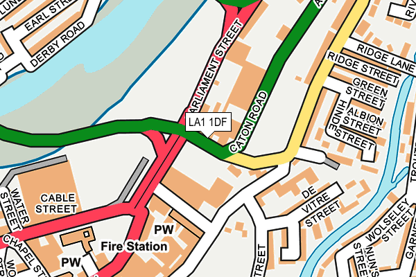
LA1 1DF is located in the Bulk electoral ward, within the local authority district of Lancaster and the English Parliamentary constituency of Lancaster and Fleetwood. The Sub Integrated Care Board (ICB) Location is NHS Lancashire and South Cumbria ICB - 01K and the police force is Lancashire. This postcode has been in use since December 2000.


GetTheData
Source: OS OpenMap – Local (Ordnance Survey)
Source: OS VectorMap District (Ordnance Survey)
Licence: Open Government Licence (requires attribution)
| Easting | 347995 |
| Northing | 462106 |
| Latitude | 54.052285 |
| Longitude | -2.795837 |
GetTheData
Source: Open Postcode Geo
Licence: Open Government Licence
| Country | England |
| Postcode District | LA1 |
➜ See where LA1 is on a map ➜ Where is Lancaster? | |
GetTheData
Source: Land Registry Price Paid Data
Licence: Open Government Licence
Elevation or altitude of LA1 1DF as distance above sea level:
| Metres | Feet | |
|---|---|---|
| Elevation | 10m | 33ft |
Elevation is measured from the approximate centre of the postcode, to the nearest point on an OS contour line from OS Terrain 50, which has contour spacing of ten vertical metres.
➜ How high above sea level am I? Find the elevation of your current position using your device's GPS.
GetTheData
Source: Open Postcode Elevation
Licence: Open Government Licence
| Ward | Bulk |
| Constituency | Lancaster And Fleetwood |
GetTheData
Source: ONS Postcode Database
Licence: Open Government Licence
| Parliament Street | Lancaster City Centre | 74m |
| Sainsbury's Layby (Parliament Street) | Lancaster City Centre | 114m |
| Parliament Street | Lancaster City Centre | 125m |
| St Leonards Gate (Bulk Road) | Ridge | 127m |
| Waring And Gillow (North Road) | Lancaster City Centre | 159m |
| Lancaster Station | 0.9km |
| Bare Lane Station | 3.6km |
| Morecambe Station | 5.2km |
GetTheData
Source: NaPTAN
Licence: Open Government Licence
GetTheData
Source: ONS Postcode Database
Licence: Open Government Licence


➜ Get more ratings from the Food Standards Agency
GetTheData
Source: Food Standards Agency
Licence: FSA terms & conditions
| Last Collection | |||
|---|---|---|---|
| Location | Mon-Fri | Sat | Distance |
| Phoenix Street | 16:00 | 12:45 | 125m |
| 17 Bulk Road | 16:00 | 11:45 | 149m |
| Stonewell Post Office | 17:30 | 12:00 | 348m |
GetTheData
Source: Dracos
Licence: Creative Commons Attribution-ShareAlike
| Risk of LA1 1DF flooding from rivers and sea | Medium |
| ➜ LA1 1DF flood map | |
GetTheData
Source: Open Flood Risk by Postcode
Licence: Open Government Licence
The below table lists the International Territorial Level (ITL) codes (formerly Nomenclature of Territorial Units for Statistics (NUTS) codes) and Local Administrative Units (LAU) codes for LA1 1DF:
| ITL 1 Code | Name |
|---|---|
| TLD | North West (England) |
| ITL 2 Code | Name |
| TLD4 | Lancashire |
| ITL 3 Code | Name |
| TLD44 | Lancaster and Wyre |
| LAU 1 Code | Name |
| E07000121 | Lancaster |
GetTheData
Source: ONS Postcode Directory
Licence: Open Government Licence
The below table lists the Census Output Area (OA), Lower Layer Super Output Area (LSOA), and Middle Layer Super Output Area (MSOA) for LA1 1DF:
| Code | Name | |
|---|---|---|
| OA | E00127358 | |
| LSOA | E01025093 | Lancaster 014A |
| MSOA | E02005234 | Lancaster 014 |
GetTheData
Source: ONS Postcode Directory
Licence: Open Government Licence
| LA1 1FD | Alfred Street | 129m |
| LA1 1DW | Gladstone Terrace | 152m |
| LA1 1DU | Hinde Street | 159m |
| LA1 1QU | De Vitre Street | 162m |
| LA1 1DN | Bulk Road | 167m |
| LA1 1DX | Hinde Street | 188m |
| LA1 1QN | Alfred Street | 191m |
| LA1 1QX | Denis Street | 199m |
| LA1 1QY | Sidney Terrace | 208m |
| LA1 1QZ | Shaw Street | 208m |
GetTheData
Source: Open Postcode Geo; Land Registry Price Paid Data
Licence: Open Government Licence