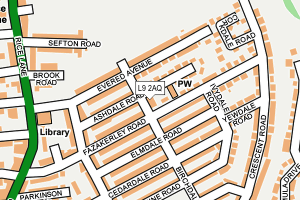
L9 2AQ is located in the Walton electoral ward, within the metropolitan district of Liverpool and the English Parliamentary constituency of Liverpool, Walton. The Sub Integrated Care Board (ICB) Location is NHS Cheshire and Merseyside ICB - 99A and the police force is Merseyside. This postcode has been in use since January 2016.


GetTheData
Source: OS OpenMap – Local (Ordnance Survey)
Source: OS VectorMap District (Ordnance Survey)
Licence: Open Government Licence (requires attribution)
| Easting | 336475 |
| Northing | 395875 |
| Latitude | 53.455781 |
| Longitude | -2.958132 |
GetTheData
Source: Open Postcode Geo
Licence: Open Government Licence
| Country | England |
| Postcode District | L9 |
| ➜ L9 open data dashboard ➜ See where L9 is on a map ➜ Where is Liverpool? | |
GetTheData
Source: Land Registry Price Paid Data
Licence: Open Government Licence
Elevation or altitude of L9 2AQ as distance above sea level:
| Metres | Feet | |
|---|---|---|
| Elevation | 30m | 98ft |
Elevation is measured from the approximate centre of the postcode, to the nearest point on an OS contour line from OS Terrain 50, which has contour spacing of ten vertical metres.
➜ How high above sea level am I? Find the elevation of your current position using your device's GPS.
GetTheData
Source: Open Postcode Elevation
Licence: Open Government Licence
| Ward | Walton |
| Constituency | Liverpool, Walton |
GetTheData
Source: ONS Postcode Database
Licence: Open Government Licence
| October 2023 | Violence and sexual offences | On or near Dahlia Close | 444m |
| July 2022 | Anti-social behaviour | On or near Lime Tree Close | 468m |
| June 2022 | Violence and sexual offences | On or near Fazakerley Road | 41m |
| ➜ Get more crime data in our Crime section | |||
GetTheData
Source: data.police.uk
Licence: Open Government Licence
| Fazakerley Road (Rice Lane) | Walton | 258m |
| Yew Tree Road (Rice Lane) | Walton | 274m |
| Buttercup Way (Lavender Way) | Walton | 376m |
| Rice Lane (Hornby Road) | Walton | 392m |
| Buttercup Way (Lavender Way) | Walton | 402m |
| Rice Lane Station | 0.4km |
| Walton (Merseyside) Station | 0.5km |
| Orrell Park Station | 0.8km |
GetTheData
Source: NaPTAN
Licence: Open Government Licence
| Percentage of properties with Next Generation Access | 100.0% |
| Percentage of properties with Superfast Broadband | 100.0% |
| Percentage of properties with Ultrafast Broadband | 25.0% |
| Percentage of properties with Full Fibre Broadband | 0.0% |
Superfast Broadband is between 30Mbps and 300Mbps
Ultrafast Broadband is > 300Mbps
| Percentage of properties unable to receive 2Mbps | 0.0% |
| Percentage of properties unable to receive 5Mbps | 0.0% |
| Percentage of properties unable to receive 10Mbps | 0.0% |
| Percentage of properties unable to receive 30Mbps | 0.0% |
GetTheData
Source: Ofcom
Licence: Ofcom Terms of Use (requires attribution)
GetTheData
Source: ONS Postcode Database
Licence: Open Government Licence


➜ Get more ratings from the Food Standards Agency
GetTheData
Source: Food Standards Agency
Licence: FSA terms & conditions
| Last Collection | |||
|---|---|---|---|
| Location | Mon-Fri | Sat | Distance |
| Rice Lane | 16:00 | 12:00 | 249m |
| Cavendish Drive | 16:00 | 12:00 | 557m |
| Walton Vale Post Office | 16:45 | 12:00 | 929m |
GetTheData
Source: Dracos
Licence: Creative Commons Attribution-ShareAlike
| Facility | Distance |
|---|---|
| Rice Lane Recreation Ground Rice Lane, Walton, Liverpool Grass Pitches | 260m |
| Archbishop Beck Community Tennis Centre Crescent Road, Walton, Liverpool Indoor Tennis Centre, Studio, Artificial Grass Pitch | 324m |
| Jacobs Sports And Social Club Long Lane, Walton, Liverpool Grass Pitches | 627m |
GetTheData
Source: Active Places
Licence: Open Government Licence
| School | Phase of Education | Distance |
|---|---|---|
| Cavendish View School 99, Cavendish drive, Liverpool, L9 1NB | Not applicable | 445m |
| Rice Lane Primary School and Nursery Brockenhurst Road, Walton, Liverpool, L9 3BU | Primary | 505m |
| Northcote Primary School Cavendish Drive, Walton, Liverpool, L9 1HW | Primary | 658m |
GetTheData
Source: Edubase
Licence: Open Government Licence
The below table lists the International Territorial Level (ITL) codes (formerly Nomenclature of Territorial Units for Statistics (NUTS) codes) and Local Administrative Units (LAU) codes for L9 2AQ:
| ITL 1 Code | Name |
|---|---|
| TLD | North West (England) |
| ITL 2 Code | Name |
| TLD7 | Merseyside |
| ITL 3 Code | Name |
| TLD72 | Liverpool |
| LAU 1 Code | Name |
| E08000012 | Liverpool |
GetTheData
Source: ONS Postcode Directory
Licence: Open Government Licence
The below table lists the Census Output Area (OA), Lower Layer Super Output Area (LSOA), and Middle Layer Super Output Area (MSOA) for L9 2AQ:
| Code | Name | |
|---|---|---|
| OA | E00034383 | |
| LSOA | E01006788 | Liverpool 006B |
| MSOA | E02001352 | Liverpool 006 |
GetTheData
Source: ONS Postcode Directory
Licence: Open Government Licence
| L9 2AB | Ashdale Road | 22m |
| L9 2AA | Ashdale Road | 31m |
| L9 2BH | Elmdale Road | 73m |
| L9 2AG | Evered Avenue | 91m |
| L9 2AF | Evered Avenue | 93m |
| L9 2AH | Fazakerley Road | 96m |
| L9 2BJ | Elmdale Road | 97m |
| L9 2AL | Fazakerley Road | 99m |
| L9 2AE | Evered Avenue | 111m |
| L9 2AD | Evered Avenue | 115m |
GetTheData
Source: Open Postcode Geo; Land Registry Price Paid Data
Licence: Open Government Licence