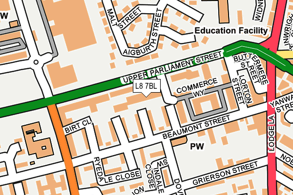
L8 7BL is located in the Princes Park electoral ward, within the metropolitan district of Liverpool and the English Parliamentary constituency of Liverpool, Riverside. The Sub Integrated Care Board (ICB) Location is NHS Cheshire and Merseyside ICB - 99A and the police force is Merseyside. This postcode has been in use since February 2010.


GetTheData
Source: OS OpenMap – Local (Ordnance Survey)
Source: OS VectorMap District (Ordnance Survey)
Licence: Open Government Licence (requires attribution)
| Easting | 336682 |
| Northing | 389419 |
| Latitude | 53.397801 |
| Longitude | -2.953715 |
GetTheData
Source: Open Postcode Geo
Licence: Open Government Licence
| Country | England |
| Postcode District | L8 |
| ➜ L8 open data dashboard ➜ See where L8 is on a map ➜ Where is Liverpool? | |
GetTheData
Source: Land Registry Price Paid Data
Licence: Open Government Licence
Elevation or altitude of L8 7BL as distance above sea level:
| Metres | Feet | |
|---|---|---|
| Elevation | 50m | 164ft |
Elevation is measured from the approximate centre of the postcode, to the nearest point on an OS contour line from OS Terrain 50, which has contour spacing of ten vertical metres.
➜ How high above sea level am I? Find the elevation of your current position using your device's GPS.
GetTheData
Source: Open Postcode Elevation
Licence: Open Government Licence
| Ward | Princes Park |
| Constituency | Liverpool, Riverside |
GetTheData
Source: ONS Postcode Database
Licence: Open Government Licence
| January 2024 | Violence and sexual offences | On or near Malt Street | 177m |
| December 2023 | Burglary | On or near Malt Street | 177m |
| December 2023 | Criminal damage and arson | On or near Malt Street | 177m |
| ➜ Get more crime data in our Crime section | |||
GetTheData
Source: data.police.uk
Licence: Open Government Licence
| Commerce Way (Upper Parliament Street) | Toxteth | 93m |
| Dove Street (Beaumont Street) | Toxteth | 109m |
| Embledon Street (Beaumont Street) | Toxteth | 133m |
| Crown Street (Upper Parliament Street) | Toxteth | 159m |
| Lorton Street (Upper Parliament Street) | Toxteth | 164m |
| Edge Hill Station | 0.7km |
| Liverpool Central Station | 1.9km |
| Liverpool Lime Street Station | 1.9km |
GetTheData
Source: NaPTAN
Licence: Open Government Licence
Estimated total energy consumption in L8 7BL by fuel type, 2015.
| Consumption (kWh) | 101,682 |
|---|---|
| Meter count | 10 |
| Mean (kWh/meter) | 10,168 |
| Median (kWh/meter) | 10,084 |
GetTheData
Source: Postcode level gas estimates: 2015 (experimental)
Source: Postcode level electricity estimates: 2015 (experimental)
Licence: Open Government Licence
GetTheData
Source: ONS Postcode Database
Licence: Open Government Licence


➜ Get more ratings from the Food Standards Agency
GetTheData
Source: Food Standards Agency
Licence: FSA terms & conditions
| Last Collection | |||
|---|---|---|---|
| Location | Mon-Fri | Sat | Distance |
| Boswell Street | 17:15 | 12:00 | 371m |
| Granby Street | 17:15 | 12:00 | 406m |
| Kingsley Road | 17:00 | 12:00 | 450m |
GetTheData
Source: Dracos
Licence: Creative Commons Attribution-ShareAlike
| Facility | Distance |
|---|---|
| Unity Youth And Community Centre Dove Street, Liverpool Sports Hall, Health and Fitness Gym | 351m |
| Tiber Park (Closed) Coltart Road, Liverpool Grass Pitches | 512m |
| Tiber Football Centre Tagus Street, Liverpool Grass Pitches, Artificial Grass Pitch | 526m |
GetTheData
Source: Active Places
Licence: Open Government Licence
| School | Phase of Education | Distance |
|---|---|---|
| Princes School Selborne Street, Liverpool, L8 1YQ | Not applicable | 220m |
| Smithdown Primary School Chatsworth Drive, Liverpool, L7 6LJ | Primary | 263m |
| Kingsley Community School Eversley Street, Liverpool, L8 2TG | Primary | 365m |
GetTheData
Source: Edubase
Licence: Open Government Licence
The below table lists the International Territorial Level (ITL) codes (formerly Nomenclature of Territorial Units for Statistics (NUTS) codes) and Local Administrative Units (LAU) codes for L8 7BL:
| ITL 1 Code | Name |
|---|---|
| TLD | North West (England) |
| ITL 2 Code | Name |
| TLD7 | Merseyside |
| ITL 3 Code | Name |
| TLD72 | Liverpool |
| LAU 1 Code | Name |
| E08000012 | Liverpool |
GetTheData
Source: ONS Postcode Directory
Licence: Open Government Licence
The below table lists the Census Output Area (OA), Lower Layer Super Output Area (LSOA), and Middle Layer Super Output Area (MSOA) for L8 7BL:
| Code | Name | |
|---|---|---|
| OA | E00033843 | |
| LSOA | E01006679 | Liverpool 039D |
| MSOA | E02001385 | Liverpool 039 |
GetTheData
Source: ONS Postcode Directory
Licence: Open Government Licence
| L8 7QE | Upper Parliament Street | 56m |
| L8 0YG | Swindale Close | 160m |
| L8 0UR | Beaumont Street | 175m |
| L8 0XA | Beaumont Street | 182m |
| L8 0YF | Ryedale Close | 188m |
| L8 0UZ | 227m | |
| L8 2XX | St Bernards Close | 238m |
| L8 0UJ | Grierson Street | 244m |
| L7 6AL | Carman Walk | 257m |
| L7 3RD | Perrygate Close | 266m |
GetTheData
Source: Open Postcode Geo; Land Registry Price Paid Data
Licence: Open Government Licence