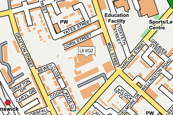
L8 6QZ is located in the Dingle electoral ward, within the metropolitan district of Liverpool and the English Parliamentary constituency of Liverpool, Riverside. The Sub Integrated Care Board (ICB) Location is NHS Cheshire and Merseyside ICB - 99A and the police force is Merseyside. This postcode has been in use since January 1980.


GetTheData
Source: OS OpenMap – Local (Ordnance Survey)
Source: OS VectorMap District (Ordnance Survey)
Licence: Open Government Licence (requires attribution)
| Easting | 335448 |
| Northing | 387978 |
| Latitude | 53.384684 |
| Longitude | -2.971975 |
GetTheData
Source: Open Postcode Geo
Licence: Open Government Licence
| Country | England |
| Postcode District | L8 |
| ➜ L8 open data dashboard ➜ See where L8 is on a map ➜ Where is Liverpool? | |
GetTheData
Source: Land Registry Price Paid Data
Licence: Open Government Licence
Elevation or altitude of L8 6QZ as distance above sea level:
| Metres | Feet | |
|---|---|---|
| Elevation | 40m | 131ft |
Elevation is measured from the approximate centre of the postcode, to the nearest point on an OS contour line from OS Terrain 50, which has contour spacing of ten vertical metres.
➜ How high above sea level am I? Find the elevation of your current position using your device's GPS.
GetTheData
Source: Open Postcode Elevation
Licence: Open Government Licence
| Ward | Dingle |
| Constituency | Liverpool, Riverside |
GetTheData
Source: ONS Postcode Database
Licence: Open Government Licence
| January 2024 | Violence and sexual offences | On or near Tillotson Close | 412m |
| December 2023 | Public order | On or near Tillotson Close | 412m |
| November 2023 | Anti-social behaviour | On or near Tillotson Close | 412m |
| ➜ Get more crime data in our Crime section | |||
GetTheData
Source: data.police.uk
Licence: Open Government Licence
| Harlow Street (Mill Street) | Toxteth | 92m |
| Lindfield Close (Harlow Street) | Toxteth | 114m |
| Corn Street (Mill Street) | Toxteth | 117m |
| Toxteth Street (Harlow Street) | Toxteth | 132m |
| Lindfield Close (Harlow Street) | Toxteth | 145m |
| Brunswick Station | 0.3km |
| St Michaels Station | 1.6km |
| Liverpool Central Station | 2.3km |
GetTheData
Source: NaPTAN
Licence: Open Government Licence
GetTheData
Source: ONS Postcode Database
Licence: Open Government Licence

➜ Get more ratings from the Food Standards Agency
GetTheData
Source: Food Standards Agency
Licence: FSA terms & conditions
| Last Collection | |||
|---|---|---|---|
| Location | Mon-Fri | Sat | Distance |
| Mill Street | 17:30 | 12:00 | 98m |
| Horsefall Street | 17:30 | 12:00 | 227m |
| Bersford Road | 17:00 | 12:00 | 364m |
GetTheData
Source: Dracos
Licence: Creative Commons Attribution-ShareAlike
| Facility | Distance |
|---|---|
| Lifestyles Park Road Steble Street, Liverpool Sports Hall, Swimming Pool, Health and Fitness Gym, Artificial Grass Pitch | 295m |
| Puregym (Liverpool Brunswick) Sefton Street, Liverpool Health and Fitness Gym | 413m |
| Nuffield Health (Liverpool) Riverside Drive, Liverpool Swimming Pool, Health and Fitness Gym, Studio | 568m |
GetTheData
Source: Active Places
Licence: Open Government Licence
| School | Phase of Education | Distance |
|---|---|---|
| Holy Family Catholic Primary School Upper Essex Street, Liverpool, L8 6QB | Primary | 272m |
| St Cleopas' Church of England Junior Mixed and Infant School Beresford Road, Liverpool, L8 4RP | Primary | 396m |
| St Silas Church of England Primary School High Park Street, Toxteth, Liverpool, L8 3TP | Primary | 800m |
GetTheData
Source: Edubase
Licence: Open Government Licence
The below table lists the International Territorial Level (ITL) codes (formerly Nomenclature of Territorial Units for Statistics (NUTS) codes) and Local Administrative Units (LAU) codes for L8 6QZ:
| ITL 1 Code | Name |
|---|---|
| TLD | North West (England) |
| ITL 2 Code | Name |
| TLD7 | Merseyside |
| ITL 3 Code | Name |
| TLD72 | Liverpool |
| LAU 1 Code | Name |
| E08000012 | Liverpool |
GetTheData
Source: ONS Postcode Directory
Licence: Open Government Licence
The below table lists the Census Output Area (OA), Lower Layer Super Output Area (LSOA), and Middle Layer Super Output Area (MSOA) for L8 6QZ:
| Code | Name | |
|---|---|---|
| OA | E00176665 | |
| LSOA | E01006630 | Liverpool 044B |
| MSOA | E02001390 | Liverpool 044 |
GetTheData
Source: ONS Postcode Directory
Licence: Open Government Licence
| L8 6RB | Corn Street | 78m |
| L8 6QR | Mill Street | 90m |
| L8 6QN | Mill Street | 134m |
| L8 6QW | Mill Street | 144m |
| L8 6RG | Grafton Street | 169m |
| L8 4YF | Lindfield Close | 170m |
| L8 4UT | Haylock Close | 190m |
| L8 6AD | Longville Street | 191m |
| L8 6RQ | Grafton Street | 204m |
| L8 4YL | Shelmore Drive | 219m |
GetTheData
Source: Open Postcode Geo; Land Registry Price Paid Data
Licence: Open Government Licence