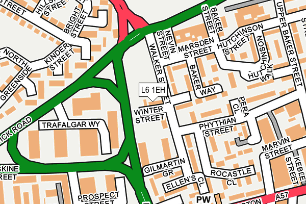
L6 1EH lies on Winter Street in Liverpool. L6 1EH is located in the Kensington & Fairfield electoral ward, within the metropolitan district of Liverpool and the English Parliamentary constituency of Liverpool, Wavertree. The Sub Integrated Care Board (ICB) Location is NHS Cheshire and Merseyside ICB - 99A and the police force is Merseyside. This postcode has been in use since January 1980.


GetTheData
Source: OS OpenMap – Local (Ordnance Survey)
Source: OS VectorMap District (Ordnance Survey)
Licence: Open Government Licence (requires attribution)
| Easting | 336169 |
| Northing | 391123 |
| Latitude | 53.413036 |
| Longitude | -2.961774 |
GetTheData
Source: Open Postcode Geo
Licence: Open Government Licence
| Street | Winter Street |
| Town/City | Liverpool |
| Country | England |
| Postcode District | L6 |
| ➜ L6 open data dashboard ➜ See where L6 is on a map ➜ Where is Liverpool? | |
GetTheData
Source: Land Registry Price Paid Data
Licence: Open Government Licence
Elevation or altitude of L6 1EH as distance above sea level:
| Metres | Feet | |
|---|---|---|
| Elevation | 60m | 197ft |
Elevation is measured from the approximate centre of the postcode, to the nearest point on an OS contour line from OS Terrain 50, which has contour spacing of ten vertical metres.
➜ How high above sea level am I? Find the elevation of your current position using your device's GPS.
GetTheData
Source: Open Postcode Elevation
Licence: Open Government Licence
| Ward | Kensington & Fairfield |
| Constituency | Liverpool, Wavertree |
GetTheData
Source: ONS Postcode Database
Licence: Open Government Licence
| January 2024 | Burglary | On or near Renfrew Street | 378m |
| January 2024 | Criminal damage and arson | On or near Renfrew Street | 378m |
| January 2024 | Criminal damage and arson | On or near Back Guilford Street | 423m |
| ➜ Get more crime data in our Crime section | |||
GetTheData
Source: data.police.uk
Licence: Open Government Licence
| Brougham Terrace (West Derby Road) | Kensington | 156m |
| Grant Gardens (Everton Road) | Everton | 189m |
| Low Hill (Kensington) | Kensington | 235m |
| Caird Street (West Derby Road) | Kensington | 244m |
| West Derby Road (Everton Road) | Everton | 250m |
| Liverpool Lime Street Low Level Station | 1.2km |
| Liverpool Lime Street Station | 1.2km |
| Liverpool Central Station | 1.5km |
GetTheData
Source: NaPTAN
Licence: Open Government Licence
| Percentage of properties with Next Generation Access | 100.0% |
| Percentage of properties with Superfast Broadband | 100.0% |
| Percentage of properties with Ultrafast Broadband | 0.0% |
| Percentage of properties with Full Fibre Broadband | 0.0% |
Superfast Broadband is between 30Mbps and 300Mbps
Ultrafast Broadband is > 300Mbps
| Percentage of properties unable to receive 2Mbps | 0.0% |
| Percentage of properties unable to receive 5Mbps | 0.0% |
| Percentage of properties unable to receive 10Mbps | 0.0% |
| Percentage of properties unable to receive 30Mbps | 0.0% |
GetTheData
Source: Ofcom
Licence: Ofcom Terms of Use (requires attribution)
GetTheData
Source: ONS Postcode Database
Licence: Open Government Licence


➜ Get more ratings from the Food Standards Agency
GetTheData
Source: Food Standards Agency
Licence: FSA terms & conditions
| Last Collection | |||
|---|---|---|---|
| Location | Mon-Fri | Sat | Distance |
| Moss Street | 17:30 | 12:00 | 443m |
| Pembroke Place | 17:30 | 12:00 | 613m |
| Monument Place Post Office | 17:30 | 12:00 | 780m |
GetTheData
Source: Dracos
Licence: Creative Commons Attribution-ShareAlike
| Facility | Distance |
|---|---|
| Central Youth Club Walker Street, Liverpool Artificial Grass Pitch, Sports Hall | 44m |
| Our Lady's Rc High School (Closed) Margaret Street, Liverpool Grass Pitches | 470m |
| Momentum Leisure Club London Road, Liverpool Swimming Pool, Health and Fitness Gym | 523m |
GetTheData
Source: Active Places
Licence: Open Government Licence
| School | Phase of Education | Distance |
|---|---|---|
| Sacred Heart Catholic Primary School and Nursery Hall Lane, Liverpool, L7 8TQ | Primary | 504m |
| Everton Nursery School and Family Centre Spencer Street, Liverpool, L6 2WF | Nursery | 597m |
| New Park Primary School 100 Boaler Street, Liverpool, L6 9EU | Primary | 647m |
GetTheData
Source: Edubase
Licence: Open Government Licence
The below table lists the International Territorial Level (ITL) codes (formerly Nomenclature of Territorial Units for Statistics (NUTS) codes) and Local Administrative Units (LAU) codes for L6 1EH:
| ITL 1 Code | Name |
|---|---|
| TLD | North West (England) |
| ITL 2 Code | Name |
| TLD7 | Merseyside |
| ITL 3 Code | Name |
| TLD72 | Liverpool |
| LAU 1 Code | Name |
| E08000012 | Liverpool |
GetTheData
Source: ONS Postcode Directory
Licence: Open Government Licence
The below table lists the Census Output Area (OA), Lower Layer Super Output Area (LSOA), and Middle Layer Super Output Area (MSOA) for L6 1EH:
| Code | Name | |
|---|---|---|
| OA | E00034222 | |
| LSOA | E01006747 | Liverpool 031B |
| MSOA | E02001377 | Liverpool 031 |
GetTheData
Source: ONS Postcode Directory
Licence: Open Government Licence
| L6 1JN | Marsden Way | 49m |
| L6 1JS | Fitzroy Way | 62m |
| L6 1EP | Marsden Street | 94m |
| L6 1EG | Gilmartin Grove | 103m |
| L6 1JL | Baker Way | 104m |
| L6 1RD | Pera Close | 148m |
| L6 1PH | Rocastle Close | 157m |
| L6 1EN | Low Wood Street | 179m |
| L6 1PQ | Gloucester Court | 181m |
| L6 1JX | Phythian Street | 183m |
GetTheData
Source: Open Postcode Geo; Land Registry Price Paid Data
Licence: Open Government Licence