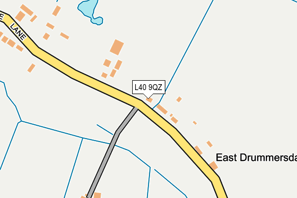
L40 9QZ lies on Drummersdale Lane in Scarisbrick, Ormskirk. L40 9QZ is located in the Rural West electoral ward, within the local authority district of West Lancashire and the English Parliamentary constituency of West Lancashire. The Sub Integrated Care Board (ICB) Location is NHS Lancashire and South Cumbria ICB - 02G and the police force is Lancashire. This postcode has been in use since January 1980.


GetTheData
Source: OS OpenMap – Local (Ordnance Survey)
Source: OS VectorMap District (Ordnance Survey)
Licence: Open Government Licence (requires attribution)
| Easting | 340537 |
| Northing | 413771 |
| Latitude | 53.617091 |
| Longitude | -2.900375 |
GetTheData
Source: Open Postcode Geo
Licence: Open Government Licence
| Street | Drummersdale Lane |
| Locality | Scarisbrick |
| Town/City | Ormskirk |
| Country | England |
| Postcode District | L40 |
| ➜ L40 open data dashboard ➜ See where L40 is on a map | |
GetTheData
Source: Land Registry Price Paid Data
Licence: Open Government Licence
Elevation or altitude of L40 9QZ as distance above sea level:
| Metres | Feet | |
|---|---|---|
| Elevation | 10m | 33ft |
Elevation is measured from the approximate centre of the postcode, to the nearest point on an OS contour line from OS Terrain 50, which has contour spacing of ten vertical metres.
➜ How high above sea level am I? Find the elevation of your current position using your device's GPS.
GetTheData
Source: Open Postcode Elevation
Licence: Open Government Licence
| Ward | Rural West |
| Constituency | West Lancashire |
GetTheData
Source: ONS Postcode Database
Licence: Open Government Licence
| March 2022 | Burglary | On or near White House Lane | 352m |
| November 2021 | Criminal damage and arson | On or near White House Lane | 352m |
| August 2021 | Anti-social behaviour | On or near White House Lane | 352m |
| ➜ Drummersdale Lane crime map and outcomes | |||
GetTheData
Source: data.police.uk
Licence: Open Government Licence
| Hillock Close | Bescar | 1,196m |
| Methodist Church (Bescar Lane) | Bescar | 1,216m |
| Methodist Church (Bescar Lane) | Bescar | 1,222m |
| Cliffe Wood (Hall Road) | Drummersdale | 1,328m |
| Cliffe Wood (Hall Road) | Bescar | 1,334m |
| Bescar Lane Station | 1.2km |
| New Lane Station | 2.2km |
| Burscough Bridge Station | 4.2km |
GetTheData
Source: NaPTAN
Licence: Open Government Licence
| Percentage of properties with Next Generation Access | 100.0% |
| Percentage of properties with Superfast Broadband | 14.3% |
| Percentage of properties with Ultrafast Broadband | 0.0% |
| Percentage of properties with Full Fibre Broadband | 0.0% |
Superfast Broadband is between 30Mbps and 300Mbps
Ultrafast Broadband is > 300Mbps
| Percentage of properties unable to receive 2Mbps | 0.0% |
| Percentage of properties unable to receive 5Mbps | 14.3% |
| Percentage of properties unable to receive 10Mbps | 14.3% |
| Percentage of properties unable to receive 30Mbps | 85.7% |
GetTheData
Source: Ofcom
Licence: Ofcom Terms of Use (requires attribution)
GetTheData
Source: ONS Postcode Database
Licence: Open Government Licence


➜ Get more ratings from the Food Standards Agency
GetTheData
Source: Food Standards Agency
Licence: FSA terms & conditions
| Last Collection | |||
|---|---|---|---|
| Location | Mon-Fri | Sat | Distance |
| Burscough Junction | 17:30 | 12:00 | 4,650m |
| 16 Russell Road | 16:30 | 11:30 | 5,416m |
| 88 Canning Road | 16:00 | 11:30 | 5,440m |
GetTheData
Source: Dracos
Licence: Creative Commons Attribution-ShareAlike
| Facility | Distance |
|---|---|
| St Mary's Catholic Primary School Hall Road, Scarisbrick, Ormskirk Grass Pitches | 1.6km |
| Scarisbrick Hall School Southport Road, Scarisbrick, Ormskirk Grass Pitches, Sports Hall, Studio | 1.8km |
| Smithy Lane Recreation Ground (Closed) Smithy Lane, Scarisbrick, Ormskirk Grass Pitches | 2.3km |
GetTheData
Source: Active Places
Licence: Open Government Licence
| School | Phase of Education | Distance |
|---|---|---|
| St Mary's Catholic Primary School, Scarisbrick Hall Road, Scarisbrick, Ormskirk, L40 9QE | Primary | 1.4km |
| Scarisbrick Hall School Southport Road, Ormskirk, L40 9RQ | Not applicable | 1.8km |
| Scarisbrick St Mark's Church of England Primary School Southport Road, Scarisbrick, Ormskirk, L40 9RE | Primary | 2.7km |
GetTheData
Source: Edubase
Licence: Open Government Licence
The below table lists the International Territorial Level (ITL) codes (formerly Nomenclature of Territorial Units for Statistics (NUTS) codes) and Local Administrative Units (LAU) codes for L40 9QZ:
| ITL 1 Code | Name |
|---|---|
| TLD | North West (England) |
| ITL 2 Code | Name |
| TLD4 | Lancashire |
| ITL 3 Code | Name |
| TLD47 | Chorley and West Lancashire |
| LAU 1 Code | Name |
| E07000127 | West Lancashire |
GetTheData
Source: ONS Postcode Directory
Licence: Open Government Licence
The below table lists the Census Output Area (OA), Lower Layer Super Output Area (LSOA), and Middle Layer Super Output Area (MSOA) for L40 9QZ:
| Code | Name | |
|---|---|---|
| OA | E00129474 | |
| LSOA | E01025514 | West Lancashire 003C |
| MSOA | E02005306 | West Lancashire 003 |
GetTheData
Source: ONS Postcode Directory
Licence: Open Government Licence
| L40 9RD | Drummersdale Lane | 278m |
| L40 0RU | Martin Lane | 688m |
| L40 9SW | Wholesome Lane | 728m |
| L40 9RB | Drummersdale Lane | 1015m |
| L40 9QY | Drummersdale Lane | 1111m |
| L40 9PZ | Lady Anne Close | 1143m |
| L40 9QA | Hillock Lane | 1178m |
| L40 9QN | Bescar Lane | 1185m |
| L40 9QD | Hall Road | 1208m |
| L40 9QR | Bescar Lane | 1229m |
GetTheData
Source: Open Postcode Geo; Land Registry Price Paid Data
Licence: Open Government Licence