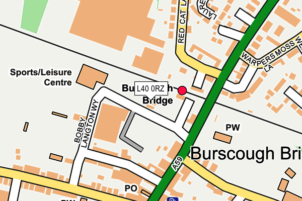
L40 0RZ is located in the Burscough Bridge & Rufford electoral ward, within the local authority district of West Lancashire and the English Parliamentary constituency of West Lancashire. The Sub Integrated Care Board (ICB) Location is NHS Lancashire and South Cumbria ICB - 02G and the police force is Lancashire. This postcode has been in use since December 1994.


GetTheData
Source: OS OpenMap – Local (Ordnance Survey)
Source: OS VectorMap District (Ordnance Survey)
Licence: Open Government Licence (requires attribution)
| Easting | 344359 |
| Northing | 412399 |
| Latitude | 53.605197 |
| Longitude | -2.842359 |
GetTheData
Source: Open Postcode Geo
Licence: Open Government Licence
| Country | England |
| Postcode District | L40 |
| ➜ L40 open data dashboard ➜ See where L40 is on a map ➜ Where is Burscough Bridge? | |
GetTheData
Source: Land Registry Price Paid Data
Licence: Open Government Licence
Elevation or altitude of L40 0RZ as distance above sea level:
| Metres | Feet | |
|---|---|---|
| Elevation | 10m | 33ft |
Elevation is measured from the approximate centre of the postcode, to the nearest point on an OS contour line from OS Terrain 50, which has contour spacing of ten vertical metres.
➜ How high above sea level am I? Find the elevation of your current position using your device's GPS.
GetTheData
Source: Open Postcode Elevation
Licence: Open Government Licence
| Ward | Burscough Bridge & Rufford |
| Constituency | West Lancashire |
GetTheData
Source: ONS Postcode Database
Licence: Open Government Licence
| January 2024 | Violence and sexual offences | On or near Station Approach | 77m |
| January 2024 | Violence and sexual offences | On or near Station Approach | 77m |
| January 2024 | Anti-social behaviour | On or near Parking Area | 323m |
| ➜ Get more crime data in our Crime section | |||
GetTheData
Source: data.police.uk
Licence: Open Government Licence
| Tesco (Station Road) | Burscough Bridge | 23m |
| Interchange (Liverpool Road North) | Burscough Bridge | 56m |
| Burscough Bridge (Liverpool Road North) | Burscough Bridge | 133m |
| Burscough Bridge (Liverpool Road North) | Burscough Bridge | 152m |
| St Johns Ceps (School Lane) | Burscough Bridge | 352m |
| Burscough Bridge Station | 0.1km |
| Burscough Junction Station | 0.9km |
| New Lane Station | 1.8km |
GetTheData
Source: NaPTAN
Licence: Open Government Licence
GetTheData
Source: ONS Postcode Database
Licence: Open Government Licence


➜ Get more ratings from the Food Standards Agency
GetTheData
Source: Food Standards Agency
Licence: FSA terms & conditions
| Last Collection | |||
|---|---|---|---|
| Location | Mon-Fri | Sat | Distance |
| Burscough Junction | 17:30 | 12:00 | 1,366m |
| Rufford Post Office | 16:45 | 11:30 | 1,408m |
| Hall Lane | 13:00 | 08:00 | 3,386m |
GetTheData
Source: Dracos
Licence: Creative Commons Attribution-ShareAlike
| Facility | Distance |
|---|---|
| Burscough Racquets & Fitness Centre Bobby Langton Way, Burscough, Ormskirk Sports Hall, Health and Fitness Gym, Squash Courts, Studio, Artificial Grass Pitch | 108m |
| The Community Ground Bobby Langton Way, Burscough Grass Pitches, Artificial Grass Pitch | 312m |
| Burscough Bridge St John's Church Of England Primary School School Lane, Burscough, Ormskirk Sports Hall, Grass Pitches | 348m |
GetTheData
Source: Active Places
Licence: Open Government Licence
| School | Phase of Education | Distance |
|---|---|---|
| Burscough Bridge Methodist School Orrell Lane, Burscough, Ormskirk, L40 0SG | Primary | 266m |
| Burscough Bridge St John's Church of England Primary School Burscough Bridge St John's Church of England Primary School, School Lane, Burscough, Ormskirk, L40 4AE | Primary | 340m |
| Burscough Village Primary School Colburne Close, Burscough, Ormskirk, L40 4LB | Primary | 385m |
GetTheData
Source: Edubase
Licence: Open Government Licence
The below table lists the International Territorial Level (ITL) codes (formerly Nomenclature of Territorial Units for Statistics (NUTS) codes) and Local Administrative Units (LAU) codes for L40 0RZ:
| ITL 1 Code | Name |
|---|---|
| TLD | North West (England) |
| ITL 2 Code | Name |
| TLD4 | Lancashire |
| ITL 3 Code | Name |
| TLD47 | Chorley and West Lancashire |
| LAU 1 Code | Name |
| E07000127 | West Lancashire |
GetTheData
Source: ONS Postcode Directory
Licence: Open Government Licence
The below table lists the Census Output Area (OA), Lower Layer Super Output Area (LSOA), and Middle Layer Super Output Area (MSOA) for L40 0RZ:
| Code | Name | |
|---|---|---|
| OA | E00129335 | |
| LSOA | E01025485 | West Lancashire 004C |
| MSOA | E02005307 | West Lancashire 004 |
GetTheData
Source: ONS Postcode Directory
Licence: Open Government Licence
| L40 0SD | Mart Lane | 127m |
| L40 0SA | Liverpool Road North | 145m |
| L40 4LQ | Warpers Moss Close | 171m |
| L40 4BY | Liverpool Road North | 173m |
| L40 0TL | Orrell Mews | 183m |
| L40 4AW | Thistle Court | 203m |
| L40 0SQ | Orrell Lane | 218m |
| L40 0SS | Laurel Avenue | 234m |
| L40 4BZ | Lord Street | 239m |
| L40 5UU | Smithy Walk | 242m |
GetTheData
Source: Open Postcode Geo; Land Registry Price Paid Data
Licence: Open Government Licence