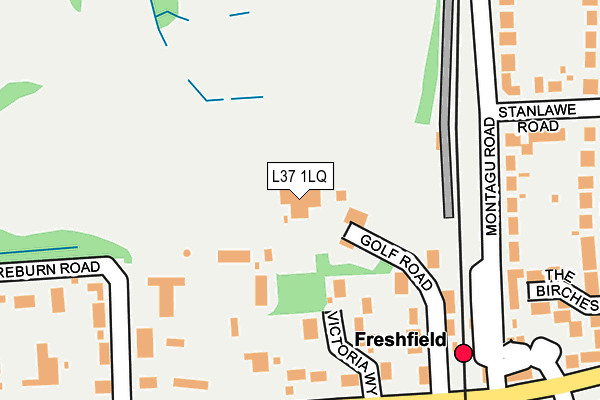
L37 1LQ is located in the Harington electoral ward, within the metropolitan district of Sefton and the English Parliamentary constituency of Sefton Central. The Sub Integrated Care Board (ICB) Location is NHS Cheshire and Merseyside ICB - 01V and the police force is Merseyside. This postcode has been in use since June 2000.


GetTheData
Source: OS OpenMap – Local (Ordnance Survey)
Source: OS VectorMap District (Ordnance Survey)
Licence: Open Government Licence (requires attribution)
| Easting | 328944 |
| Northing | 408427 |
| Latitude | 53.567620 |
| Longitude | -3.074376 |
GetTheData
Source: Open Postcode Geo
Licence: Open Government Licence
| Country | England |
| Postcode District | L37 |
| ➜ L37 open data dashboard ➜ See where L37 is on a map ➜ Where is Formby? | |
GetTheData
Source: Land Registry Price Paid Data
Licence: Open Government Licence
Elevation or altitude of L37 1LQ as distance above sea level:
| Metres | Feet | |
|---|---|---|
| Elevation | 10m | 33ft |
Elevation is measured from the approximate centre of the postcode, to the nearest point on an OS contour line from OS Terrain 50, which has contour spacing of ten vertical metres.
➜ How high above sea level am I? Find the elevation of your current position using your device's GPS.
GetTheData
Source: Open Postcode Elevation
Licence: Open Government Licence
| Ward | Harington |
| Constituency | Sefton Central |
GetTheData
Source: ONS Postcode Database
Licence: Open Government Licence
| September 2023 | Other theft | On or near Parking Area | 207m |
| June 2022 | Anti-social behaviour | On or near Stanlawe Road | 266m |
| May 2022 | Burglary | On or near College Path | 287m |
| ➜ Get more crime data in our Crime section | |||
GetTheData
Source: data.police.uk
Licence: Open Government Licence
| Freshfield Station (Victoria Road) | Freshfield | 213m |
| Freshfield Station (Victoria Road) | Freshfield | 221m |
| Shireburn Road (Victoria Road) | Freshfield | 272m |
| Shireburn Road (Victoria Road) | Freshfield | 295m |
| Freshfield Station (Victoria Road) | Freshfield | 309m |
| Freshfield Station | 0.2km |
| Formby Station | 1.6km |
| Ainsdale Station | 4.4km |
GetTheData
Source: NaPTAN
Licence: Open Government Licence
GetTheData
Source: ONS Postcode Database
Licence: Open Government Licence


➜ Get more ratings from the Food Standards Agency
GetTheData
Source: Food Standards Agency
Licence: FSA terms & conditions
| Last Collection | |||
|---|---|---|---|
| Location | Mon-Fri | Sat | Distance |
| Freshfield Station | 17:00 | 12:00 | 410m |
| Freshfield Post Office | 17:15 | 12:00 | 738m |
| Formby Post Office | 17:15 | 12:00 | 1,487m |
GetTheData
Source: Dracos
Licence: Creative Commons Attribution-ShareAlike
| Facility | Distance |
|---|---|
| Formby Golf Club Golf Road, Liverpool Golf | 0m |
| Formby Ladies Golf Club Golf Road, Formby, Liverpool Golf | 42m |
| Clarence Sports Field (Greenloons Formby Jfc) West Lane, Formby, Liverpool Grass Pitches | 586m |
GetTheData
Source: Active Places
Licence: Open Government Licence
| School | Phase of Education | Distance |
|---|---|---|
| Formby High School Freshfield Road, Formby, Liverpool, L37 3HW | Secondary | 861m |
| Trinity St Peter's CofE Primary School Paradise Lane, Formby, Liverpool, L37 7EJ | Primary | 1.2km |
| Woodlands Primary School Woodlands Road, Formby, Liverpool, L37 2JN | Primary | 1.3km |
GetTheData
Source: Edubase
Licence: Open Government Licence
The below table lists the International Territorial Level (ITL) codes (formerly Nomenclature of Territorial Units for Statistics (NUTS) codes) and Local Administrative Units (LAU) codes for L37 1LQ:
| ITL 1 Code | Name |
|---|---|
| TLD | North West (England) |
| ITL 2 Code | Name |
| TLD7 | Merseyside |
| ITL 3 Code | Name |
| TLD73 | Sefton |
| LAU 1 Code | Name |
| E08000014 | Sefton |
GetTheData
Source: ONS Postcode Directory
Licence: Open Government Licence
The below table lists the Census Output Area (OA), Lower Layer Super Output Area (LSOA), and Middle Layer Super Output Area (MSOA) for L37 1LQ:
| Code | Name | |
|---|---|---|
| OA | E00035453 | |
| LSOA | E01006986 | Sefton 013B |
| MSOA | E02001441 | Sefton 013 |
GetTheData
Source: ONS Postcode Directory
Licence: Open Government Licence
| L37 1YH | Golf Road | 130m |
| L37 1YF | Victoria Way | 134m |
| L37 1LL | Victoria Road | 176m |
| L37 1LA | Montagu Road | 243m |
| L37 1LD | Stanlawe Road | 267m |
| L37 1LF | Montagu Mews | 279m |
| L37 7HX | The Birches | 285m |
| L37 1LE | College Avenue | 286m |
| L37 7DB | Victoria Road | 286m |
| L37 1XX | Fishermans Close | 331m |
GetTheData
Source: Open Postcode Geo; Land Registry Price Paid Data
Licence: Open Government Licence