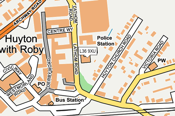
L36 9XU is located in the St Gabriels electoral ward, within the metropolitan district of Knowsley and the English Parliamentary constituency of Knowsley. The Sub Integrated Care Board (ICB) Location is NHS Cheshire and Merseyside ICB - 01J and the police force is Merseyside. This postcode has been in use since January 1980.


GetTheData
Source: OS OpenMap – Local (Ordnance Survey)
Source: OS VectorMap District (Ordnance Survey)
Licence: Open Government Licence (requires attribution)
| Easting | 344440 |
| Northing | 390848 |
| Latitude | 53.411502 |
| Longitude | -2.837308 |
GetTheData
Source: Open Postcode Geo
Licence: Open Government Licence
| Country | England |
| Postcode District | L36 |
| ➜ L36 open data dashboard ➜ See where L36 is on a map ➜ Where is Huyton with Roby? | |
GetTheData
Source: Land Registry Price Paid Data
Licence: Open Government Licence
Elevation or altitude of L36 9XU as distance above sea level:
| Metres | Feet | |
|---|---|---|
| Elevation | 40m | 131ft |
Elevation is measured from the approximate centre of the postcode, to the nearest point on an OS contour line from OS Terrain 50, which has contour spacing of ten vertical metres.
➜ How high above sea level am I? Find the elevation of your current position using your device's GPS.
GetTheData
Source: Open Postcode Elevation
Licence: Open Government Licence
| Ward | St Gabriels |
| Constituency | Knowsley |
GetTheData
Source: ONS Postcode Database
Licence: Open Government Licence
| January 2024 | Other crime | On or near Parking Area | 82m |
| January 2024 | Criminal damage and arson | On or near Parking Area | 82m |
| December 2023 | Robbery | On or near Parking Area | 82m |
| ➜ Get more crime data in our Crime section | |||
GetTheData
Source: data.police.uk
Licence: Open Government Licence
| Police Station (Lathom Road) | Huyton | 50m |
| Huyton Road (Lathom Road) | Knowsley | 161m |
| Huyton Road (Lathom Road) | Knowsley | 171m |
| Seel Road (Victoria Road) | Knowsley | 174m |
| Huyton Hey Road (Victoria Road) | Huyton | 186m |
| Huyton Station | 0.4km |
| Roby Station | 1.2km |
| Whiston Station | 2.7km |
GetTheData
Source: NaPTAN
Licence: Open Government Licence
GetTheData
Source: ONS Postcode Database
Licence: Open Government Licence


➜ Get more ratings from the Food Standards Agency
GetTheData
Source: Food Standards Agency
Licence: FSA terms & conditions
| Last Collection | |||
|---|---|---|---|
| Location | Mon-Fri | Sat | Distance |
| Huyton Post Office | 17:45 | 12:00 | 152m |
| Glade Road | 17:00 | 12:00 | 1,023m |
| The Boundary | 17:30 | 12:00 | 1,282m |
GetTheData
Source: Dracos
Licence: Creative Commons Attribution-ShareAlike
| Facility | Distance |
|---|---|
| Knowsley Hey Arts College (Closed) Seel Road, Huyton, Liverpool Sports Hall, Grass Pitches | 445m |
| Huyton Cricket Club (Closed) St. Mathews Close, Huyton, Liverpool Grass Pitches | 466m |
| Lord Derby Academy Seel Road, Liverpool Health and Fitness Gym, Sports Hall, Artificial Grass Pitch, Grass Pitches, Studio | 479m |
GetTheData
Source: Active Places
Licence: Open Government Licence
| School | Phase of Education | Distance |
|---|---|---|
| Lawrence House School 8 Huyton Church Road, Huyton, Liverpool, L36 5SJ | Not applicable | 100m |
| Lord Derby Academy Seel Road, Huyton, Liverpool, L36 6DG | Secondary | 228m |
| A.R.T.S. Education 167a Ormskirk Road, Rainford, St Helens, Merseyside, WA11 8HR | Not applicable | 501m |
GetTheData
Source: Edubase
Licence: Open Government Licence
The below table lists the International Territorial Level (ITL) codes (formerly Nomenclature of Territorial Units for Statistics (NUTS) codes) and Local Administrative Units (LAU) codes for L36 9XU:
| ITL 1 Code | Name |
|---|---|
| TLD | North West (England) |
| ITL 2 Code | Name |
| TLD7 | Merseyside |
| ITL 3 Code | Name |
| TLD71 | East Merseyside |
| LAU 1 Code | Name |
| E08000011 | Knowsley |
GetTheData
Source: ONS Postcode Directory
Licence: Open Government Licence
The below table lists the Census Output Area (OA), Lower Layer Super Output Area (LSOA), and Middle Layer Super Output Area (MSOA) for L36 9XU:
| Code | Name | |
|---|---|---|
| OA | E00032858 | |
| LSOA | E01006481 | Knowsley 015E |
| MSOA | E02001341 | Knowsley 015 |
GetTheData
Source: ONS Postcode Directory
Licence: Open Government Licence
| L36 5SH | Huyton Church Road | 110m |
| L36 5YH | Huyton Hey Road | 121m |
| L36 5SJ | Huyton Church Road | 122m |
| L36 5SA | Victoria Road | 159m |
| L36 5SE | Huyton Hey Road | 209m |
| L36 5SP | St Marys Road | 240m |
| L36 5SD | Victoria Road | 244m |
| L36 5SW | Hey Road | 263m |
| L36 5SS | St Marys Road | 282m |
| L36 6HR | Hey Park | 288m |
GetTheData
Source: Open Postcode Geo; Land Registry Price Paid Data
Licence: Open Government Licence