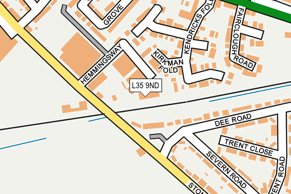
L35 9ND is located in the Rainhill electoral ward, within the metropolitan district of St. Helens and the English Parliamentary constituency of St Helens South and Whiston. The Sub Integrated Care Board (ICB) Location is NHS Cheshire and Merseyside ICB - 01X and the police force is Merseyside. This postcode has been in use since June 2000.


GetTheData
Source: OS OpenMap – Local (Ordnance Survey)
Source: OS VectorMap District (Ordnance Survey)
Licence: Open Government Licence (requires attribution)
| Easting | 348525 |
| Northing | 391310 |
| Latitude | 53.416070 |
| Longitude | -2.775935 |
GetTheData
Source: Open Postcode Geo
Licence: Open Government Licence
| Country | England |
| Postcode District | L35 |
| ➜ L35 open data dashboard ➜ See where L35 is on a map ➜ Where is Prescot? | |
GetTheData
Source: Land Registry Price Paid Data
Licence: Open Government Licence
Elevation or altitude of L35 9ND as distance above sea level:
| Metres | Feet | |
|---|---|---|
| Elevation | 70m | 230ft |
Elevation is measured from the approximate centre of the postcode, to the nearest point on an OS contour line from OS Terrain 50, which has contour spacing of ten vertical metres.
➜ How high above sea level am I? Find the elevation of your current position using your device's GPS.
GetTheData
Source: Open Postcode Elevation
Licence: Open Government Licence
| Ward | Rainhill |
| Constituency | St Helens South And Whiston |
GetTheData
Source: ONS Postcode Database
Licence: Open Government Licence
| November 2023 | Criminal damage and arson | On or near Danby Fold | 151m |
| November 2023 | Anti-social behaviour | On or near Danby Fold | 151m |
| June 2022 | Other theft | On or near Kirkman Fold | 85m |
| ➜ Get more crime data in our Crime section | |||
GetTheData
Source: data.police.uk
Licence: Open Government Licence
| Hemmingsway (Stoney Lane) | Whiston | 210m |
| Kendal Drive (Stoney Lane) | Holt | 227m |
| Kendal Drive (Warrington Road) | Holt | 301m |
| Ivy Farm Road (Warrington Road) | Holt | 306m |
| Trent Road (Stoney Lane) | Rainhill | 321m |
| Rainhill Station | 0.6km |
| Whiston Station | 1.4km |
| Eccleston Park Station | 1.7km |
GetTheData
Source: NaPTAN
Licence: Open Government Licence
GetTheData
Source: ONS Postcode Database
Licence: Open Government Licence


➜ Get more ratings from the Food Standards Agency
GetTheData
Source: Food Standards Agency
Licence: FSA terms & conditions
| Last Collection | |||
|---|---|---|---|
| Location | Mon-Fri | Sat | Distance |
| Beechwood Grove | 17:15 | 12:00 | 1,301m |
| Prescot Station | 17:30 | 12:00 | 2,180m |
| Halsnead Avenue | 16:30 | 11:30 | 2,424m |
GetTheData
Source: Dracos
Licence: Creative Commons Attribution-ShareAlike
| Facility | Distance |
|---|---|
| St Edmunds Arrowsmith Catholic High School Cumber Lane, Whiston, Prescot Health and Fitness Gym, Sports Hall, Artificial Grass Pitch, Grass Pitches, Studio | 500m |
| The Holt Playing Fields Martin Close, Rainhill, Prescot Grass Pitches | 602m |
| Higher Side Community School (Closed) Cumber Lane, Whiston, Prescot Sports Hall, Grass Pitches, Health and Fitness Gym, Squash Courts | 604m |
GetTheData
Source: Active Places
Licence: Open Government Licence
| School | Phase of Education | Distance |
|---|---|---|
| Saint Edmund Arrowsmith Catholic Academy Cumber Lane, Whiston, Liverpool, L35 2XG | Secondary | 500m |
| St Ann's Church of England Primary School View Road, Rainhill, Prescot, L35 0LQ | Primary | 688m |
| Longton Lane Community Primary School Longton Lane, Rainhill, St Helens, L35 8PB | Primary | 748m |
GetTheData
Source: Edubase
Licence: Open Government Licence
The below table lists the International Territorial Level (ITL) codes (formerly Nomenclature of Territorial Units for Statistics (NUTS) codes) and Local Administrative Units (LAU) codes for L35 9ND:
| ITL 1 Code | Name |
|---|---|
| TLD | North West (England) |
| ITL 2 Code | Name |
| TLD7 | Merseyside |
| ITL 3 Code | Name |
| TLD71 | East Merseyside |
| LAU 1 Code | Name |
| E08000013 | St. Helens |
GetTheData
Source: ONS Postcode Directory
Licence: Open Government Licence
The below table lists the Census Output Area (OA), Lower Layer Super Output Area (LSOA), and Middle Layer Super Output Area (MSOA) for L35 9ND:
| Code | Name | |
|---|---|---|
| OA | E00034953 | |
| LSOA | E01006891 | St. Helens 023C |
| MSOA | E02001428 | St. Helens 023 |
GetTheData
Source: ONS Postcode Directory
Licence: Open Government Licence
| L35 9LA | Stoney View | 63m |
| L35 9LU | Kirkman Fold | 77m |
| L35 9LX | Kendricks Fold | 113m |
| L35 9LT | Goldsworth Fold | 155m |
| L35 9LY | Danby Fold | 165m |
| L35 9AB | Stephenson Grove | 179m |
| L35 9LG | Dee Road | 201m |
| L35 9LQ | Dee Road | 204m |
| L35 9JG | Fairclough Road | 223m |
| L35 9JY | Stoney Lane | 225m |
GetTheData
Source: Open Postcode Geo; Land Registry Price Paid Data
Licence: Open Government Licence