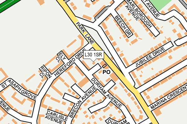
L30 1SR is located in the Netherton and Orrell electoral ward, within the metropolitan district of Sefton and the English Parliamentary constituency of Bootle. The Sub Integrated Care Board (ICB) Location is NHS Cheshire and Merseyside ICB - 01T and the police force is Merseyside. This postcode has been in use since February 1990.


GetTheData
Source: OS OpenMap – Local (Ordnance Survey)
Source: OS VectorMap District (Ordnance Survey)
Licence: Open Government Licence (requires attribution)
| Easting | 336026 |
| Northing | 398455 |
| Latitude | 53.478929 |
| Longitude | -2.965418 |
GetTheData
Source: Open Postcode Geo
Licence: Open Government Licence
| Country | England |
| Postcode District | L30 |
| ➜ L30 open data dashboard ➜ See where L30 is on a map ➜ Where is Bootle? | |
GetTheData
Source: Land Registry Price Paid Data
Licence: Open Government Licence
Elevation or altitude of L30 1SR as distance above sea level:
| Metres | Feet | |
|---|---|---|
| Elevation | 20m | 66ft |
Elevation is measured from the approximate centre of the postcode, to the nearest point on an OS contour line from OS Terrain 50, which has contour spacing of ten vertical metres.
➜ How high above sea level am I? Find the elevation of your current position using your device's GPS.
GetTheData
Source: Open Postcode Elevation
Licence: Open Government Licence
| Ward | Netherton And Orrell |
| Constituency | Bootle |
GetTheData
Source: ONS Postcode Database
Licence: Open Government Licence
| August 2023 | Violence and sexual offences | On or near Hexham Close | 427m |
| August 2023 | Violence and sexual offences | On or near Hexham Close | 427m |
| July 2023 | Violence and sexual offences | On or near Hexham Close | 427m |
| ➜ Get more crime data in our Crime section | |||
GetTheData
Source: data.police.uk
Licence: Open Government Licence
| Breacon Walk (Park Lane) | Netherton | 50m |
| Jubilee Drive (Park Lane) | Netherton | 74m |
| Dunnings Bridge Road (Park Lane) | Netherton | 123m |
| Dunnings Bridge Road (Park Lane) | Netherton | 160m |
| Park Lane (Dunnings Bridge Road) | Netherton | 306m |
| Aintree Station | 0.8km |
| Old Roan Station | 1.3km |
| Orrell Park Station | 1.9km |
GetTheData
Source: NaPTAN
Licence: Open Government Licence
| Percentage of properties with Next Generation Access | 100.0% |
| Percentage of properties with Superfast Broadband | 100.0% |
| Percentage of properties with Ultrafast Broadband | 100.0% |
| Percentage of properties with Full Fibre Broadband | 0.0% |
Superfast Broadband is between 30Mbps and 300Mbps
Ultrafast Broadband is > 300Mbps
| Percentage of properties unable to receive 2Mbps | 0.0% |
| Percentage of properties unable to receive 5Mbps | 0.0% |
| Percentage of properties unable to receive 10Mbps | 0.0% |
| Percentage of properties unable to receive 30Mbps | 0.0% |
GetTheData
Source: Ofcom
Licence: Ofcom Terms of Use (requires attribution)
GetTheData
Source: ONS Postcode Database
Licence: Open Government Licence


➜ Get more ratings from the Food Standards Agency
GetTheData
Source: Food Standards Agency
Licence: FSA terms & conditions
| Last Collection | |||
|---|---|---|---|
| Location | Mon-Fri | Sat | Distance |
| Marion Square Post Office | 17:00 | 12:00 | 1,143m |
| Old Roan Post Office | 16:40 | 12:00 | 1,353m |
| Wembley Gardens | 16:00 | 12:00 | 1,514m |
GetTheData
Source: Dracos
Licence: Creative Commons Attribution-ShareAlike
| Facility | Distance |
|---|---|
| Everton Fc Youth Development Centre (Closed) Park Lane, Netherton, Bootle Grass Pitches | 235m |
| Goals (Liverpool North) Park Lane, Netherton, Bootle Artificial Grass Pitch | 266m |
| Netherton Park Neighbourhood Centre Chester Avenue, Bootle Grass Pitches | 420m |
GetTheData
Source: Active Places
Licence: Open Government Licence
| School | Phase of Education | Distance |
|---|---|---|
| Our Lady of Walsingham Primary School Stand Park avenue, Netherton, Bootle, L30 3SA | Primary | 499m |
| The Salesian Academy of St John Bosco Netherton Way, Bootle, L30 2NA | Secondary | 841m |
| St Oswald's Church of England Primary School Ronald Ross Avenue, Netherton, Bootle, L30 5RH | Primary | 914m |
GetTheData
Source: Edubase
Licence: Open Government Licence
The below table lists the International Territorial Level (ITL) codes (formerly Nomenclature of Territorial Units for Statistics (NUTS) codes) and Local Administrative Units (LAU) codes for L30 1SR:
| ITL 1 Code | Name |
|---|---|
| TLD | North West (England) |
| ITL 2 Code | Name |
| TLD7 | Merseyside |
| ITL 3 Code | Name |
| TLD73 | Sefton |
| LAU 1 Code | Name |
| E08000014 | Sefton |
GetTheData
Source: ONS Postcode Directory
Licence: Open Government Licence
The below table lists the Census Output Area (OA), Lower Layer Super Output Area (LSOA), and Middle Layer Super Output Area (MSOA) for L30 1SR:
| Code | Name | |
|---|---|---|
| OA | E00035709 | |
| LSOA | E01007048 | Sefton 029A |
| MSOA | E02001457 | Sefton 029 |
GetTheData
Source: ONS Postcode Directory
Licence: Open Government Licence
| L30 1QQ | Park Lane | 72m |
| L30 1RF | Durham Avenue | 98m |
| L30 1QL | Ely Close | 101m |
| L30 1QY | Hereford Drive | 103m |
| L30 1RE | Durham Avenue | 106m |
| L30 1RW | Park Lane | 108m |
| L30 1QU | Coventry Avenue | 113m |
| L30 1SA | Beech Grove | 135m |
| L30 1QJ | Southwark Grove | 138m |
| L30 1QZ | Hereford Drive | 151m |
GetTheData
Source: Open Postcode Geo; Land Registry Price Paid Data
Licence: Open Government Licence