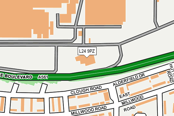
L24 9PZ is located in the Halewood South electoral ward, within the metropolitan district of Knowsley and the English Parliamentary constituency of Garston and Halewood. The Sub Integrated Care Board (ICB) Location is NHS Cheshire and Merseyside ICB - 01J and the police force is Merseyside. This postcode has been in use since May 2011.


GetTheData
Source: OS OpenMap – Local (Ordnance Survey)
Source: OS VectorMap District (Ordnance Survey)
Licence: Open Government Licence (requires attribution)
| Easting | 344795 |
| Northing | 383680 |
| Latitude | 53.347132 |
| Longitude | -2.830713 |
GetTheData
Source: Open Postcode Geo
Licence: Open Government Licence
| Country | England |
| Postcode District | L24 |
| ➜ L24 open data dashboard ➜ See where L24 is on a map ➜ Where is Liverpool? | |
GetTheData
Source: Land Registry Price Paid Data
Licence: Open Government Licence
Elevation or altitude of L24 9PZ as distance above sea level:
| Metres | Feet | |
|---|---|---|
| Elevation | 20m | 66ft |
Elevation is measured from the approximate centre of the postcode, to the nearest point on an OS contour line from OS Terrain 50, which has contour spacing of ten vertical metres.
➜ How high above sea level am I? Find the elevation of your current position using your device's GPS.
GetTheData
Source: Open Postcode Elevation
Licence: Open Government Licence
| Ward | Halewood South |
| Constituency | Garston And Halewood |
GetTheData
Source: ONS Postcode Database
Licence: Open Government Licence
| January 2024 | Violence and sexual offences | On or near Ramsfield Road | 472m |
| November 2023 | Violence and sexual offences | On or near Ramsfield Road | 472m |
| November 2023 | Drugs | On or near Ramsfield Road | 472m |
| ➜ Get more crime data in our Crime section | |||
GetTheData
Source: data.police.uk
Licence: Open Government Licence
| Clough Road (Eastern Avenue) | Speke | 153m |
| Oldbridge Road (Millwood Road) | Speke | 187m |
| Eastern Avenue (Millwood Road) | Speke | 191m |
| East Millwood Road (Eastern Avenue) | Speke | 227m |
| Oldbridge Road (Millwood Road) | Speke | 260m |
| Halewood Station | 1.9km |
| Hunts Cross Station | 2.3km |
| Liverpool South Parkway Station | 4.1km |
GetTheData
Source: NaPTAN
Licence: Open Government Licence
GetTheData
Source: ONS Postcode Database
Licence: Open Government Licence


➜ Get more ratings from the Food Standards Agency
GetTheData
Source: Food Standards Agency
Licence: FSA terms & conditions
| Last Collection | |||
|---|---|---|---|
| Location | Mon-Fri | Sat | Distance |
| Eastern Avenue | 16:30 | 12:00 | 201m |
| Ramsfield Road | 16:30 | 12:00 | 480m |
| Littleheath Road | 16:30 | 12:00 | 526m |
GetTheData
Source: Dracos
Licence: Creative Commons Attribution-ShareAlike
| Facility | Distance |
|---|---|
| Middlefield Community Primary School Alderwood Avenue, Liverpool Grass Pitches | 552m |
| Alderwood Junior Mixed Infant School (Closed) Alderwood Avenue, Speke, Liverpool Grass Pitches | 556m |
| Speke Youth & Community Centre (Parklands School) (Closed) Ganworth Road, Liverpool Sports Hall, Grass Pitches | 738m |
GetTheData
Source: Active Places
Licence: Open Government Licence
| School | Phase of Education | Distance |
|---|---|---|
| Middlefield Community Primary School Alderwood Avenue, Speke, Liverpool, L24 2UE | Primary | 540m |
| St Ambrose Catholic Academy Alderfield Drive, Speke, Liverpool, L24 7SF | Primary | 935m |
| St Christopher's Catholic Primary School Tarbock Road, Speke, Liverpool, L24 0SN | Primary | 974m |
GetTheData
Source: Edubase
Licence: Open Government Licence
The below table lists the International Territorial Level (ITL) codes (formerly Nomenclature of Territorial Units for Statistics (NUTS) codes) and Local Administrative Units (LAU) codes for L24 9PZ:
| ITL 1 Code | Name |
|---|---|
| TLD | North West (England) |
| ITL 2 Code | Name |
| TLD7 | Merseyside |
| ITL 3 Code | Name |
| TLD71 | East Merseyside |
| LAU 1 Code | Name |
| E08000011 | Knowsley |
GetTheData
Source: ONS Postcode Directory
Licence: Open Government Licence
The below table lists the Census Output Area (OA), Lower Layer Super Output Area (LSOA), and Middle Layer Super Output Area (MSOA) for L24 9PZ:
| Code | Name | |
|---|---|---|
| OA | E00032581 | |
| LSOA | E01006429 | Knowsley 020C |
| MSOA | E02001346 | Knowsley 020 |
GetTheData
Source: ONS Postcode Directory
Licence: Open Government Licence
| L24 2UX | Clough Road | 128m |
| L24 2UR | Millwood Road | 167m |
| L24 2UY | Gatley Walk | 184m |
| L24 2UG | Heaton Close | 235m |
| L24 2US | Pately Walk | 245m |
| L24 2UU | Clough Road | 278m |
| L24 6SU | Alderfield Drive | 289m |
| L24 6SE | East Millwood Road | 294m |
| L24 2TA | Eastern Avenue | 301m |
| L24 2UH | Heaton Close | 307m |
GetTheData
Source: Open Postcode Geo; Land Registry Price Paid Data
Licence: Open Government Licence