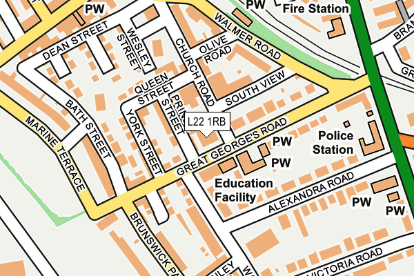
L22 1RB is located in the Church electoral ward, within the metropolitan district of Sefton and the English Parliamentary constituency of Bootle. The Sub Integrated Care Board (ICB) Location is NHS Cheshire and Merseyside ICB - 01T and the police force is Merseyside. This postcode has been in use since January 1980.


GetTheData
Source: OS OpenMap – Local (Ordnance Survey)
Source: OS VectorMap District (Ordnance Survey)
Licence: Open Government Licence (requires attribution)
| Easting | 332041 |
| Northing | 397786 |
| Latitude | 53.472417 |
| Longitude | -3.025307 |
GetTheData
Source: Open Postcode Geo
Licence: Open Government Licence
| Country | England |
| Postcode District | L22 |
| ➜ L22 open data dashboard ➜ See where L22 is on a map ➜ Where is Crosby? | |
GetTheData
Source: Land Registry Price Paid Data
Licence: Open Government Licence
Elevation or altitude of L22 1RB as distance above sea level:
| Metres | Feet | |
|---|---|---|
| Elevation | 10m | 33ft |
Elevation is measured from the approximate centre of the postcode, to the nearest point on an OS contour line from OS Terrain 50, which has contour spacing of ten vertical metres.
➜ How high above sea level am I? Find the elevation of your current position using your device's GPS.
GetTheData
Source: Open Postcode Elevation
Licence: Open Government Licence
| Ward | Church |
| Constituency | Bootle |
GetTheData
Source: ONS Postcode Database
Licence: Open Government Licence
| October 2023 | Violence and sexual offences | On or near Greenbank | 349m |
| June 2023 | Anti-social behaviour | On or near Greenbank | 349m |
| June 2023 | Criminal damage and arson | On or near Greenbank | 349m |
| ➜ Get more crime data in our Crime section | |||
GetTheData
Source: data.police.uk
Licence: Open Government Licence
| Waterloo Station (South Road) | Waterloo | 262m |
| Bramhall Road (Crosby Road South) | Waterloo | 268m |
| Waterloo Station (South Road) | Waterloo | 278m |
| South Road (Mount Pleasant) | Waterloo | 278m |
| South Road (Mount Pleasant) | Waterloo | 286m |
| Waterloo (Merseyside) Station | 0.3km |
| Seaforth & Litherland Station | 1.5km |
| Blundellsands & Crosby Station | 2km |
GetTheData
Source: NaPTAN
Licence: Open Government Licence
GetTheData
Source: ONS Postcode Database
Licence: Open Government Licence


➜ Get more ratings from the Food Standards Agency
GetTheData
Source: Food Standards Agency
Licence: FSA terms & conditions
| Last Collection | |||
|---|---|---|---|
| Location | Mon-Fri | Sat | Distance |
| Mount Pleasant | 16:45 | 12:00 | 282m |
| Waterloo Mspo, 10 Lorne Road | 17:00 | 12:00 | 333m |
| Crosby Delivery Office | 16:45 | 12:00 | 349m |
GetTheData
Source: Dracos
Licence: Creative Commons Attribution-ShareAlike
| Facility | Distance |
|---|---|
| Crosby Lakeside Adventure Centre Cambridge Road, Waterloo, Liverpool Health and Fitness Gym, Studio | 353m |
| Energie Fitness Club (Liverpool Waterloo) (Closed) South Road, Waterloo, Liverpool Health and Fitness Gym | 381m |
| Waterloo Lawn Tennis Club Park Road, Park Road, Waterloo Outdoor Tennis Courts | 538m |
GetTheData
Source: Active Places
Licence: Open Government Licence
| School | Phase of Education | Distance |
|---|---|---|
| Waterloo Primary School Crosby Road North, Waterloo, Liverpool, L22 0LD | Primary | 650m |
| St John's Church of England Primary School Denmark Street, Waterloo, Liverpool, L22 9RG | Primary | 674m |
| St Edmund's and St Thomas' Catholic Primary School Oxford Road, Waterloo, Liverpool, L22 8QF | Primary | 720m |
GetTheData
Source: Edubase
Licence: Open Government Licence
The below table lists the International Territorial Level (ITL) codes (formerly Nomenclature of Territorial Units for Statistics (NUTS) codes) and Local Administrative Units (LAU) codes for L22 1RB:
| ITL 1 Code | Name |
|---|---|
| TLD | North West (England) |
| ITL 2 Code | Name |
| TLD7 | Merseyside |
| ITL 3 Code | Name |
| TLD73 | Sefton |
| LAU 1 Code | Name |
| E08000014 | Sefton |
GetTheData
Source: ONS Postcode Directory
Licence: Open Government Licence
The below table lists the Census Output Area (OA), Lower Layer Super Output Area (LSOA), and Middle Layer Super Output Area (MSOA) for L22 1RB:
| Code | Name | |
|---|---|---|
| OA | E00035249 | |
| LSOA | E01006957 | Sefton 032C |
| MSOA | E02001460 | Sefton 032 |
GetTheData
Source: ONS Postcode Directory
Licence: Open Government Licence
| L22 5PB | Prince Street | 41m |
| L22 1RA | Great Georges Road | 47m |
| L22 5AB | Queen Street | 75m |
| L22 5PD | York Street | 81m |
| L22 5NB | Church Road | 86m |
| L22 5ND | South View | 95m |
| L22 5BD | South View | 95m |
| L22 5PA | Queen Street | 96m |
| L22 1RD | Great Georges Road | 123m |
| L22 5PS | Bath Street | 148m |
GetTheData
Source: Open Postcode Geo; Land Registry Price Paid Data
Licence: Open Government Licence