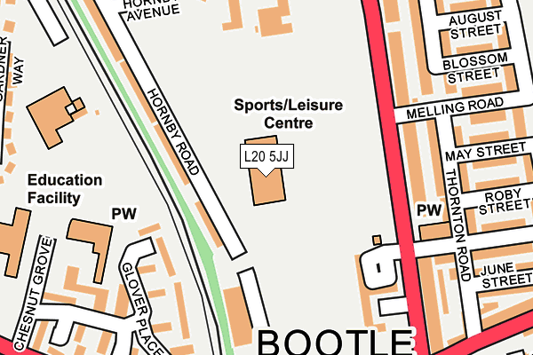
L20 5JJ is located in the Linacre electoral ward, within the metropolitan district of Sefton and the English Parliamentary constituency of Bootle. The Sub Integrated Care Board (ICB) Location is NHS Cheshire and Merseyside ICB - 01T and the police force is Merseyside. This postcode has been in use since December 1996.


GetTheData
Source: OS OpenMap – Local (Ordnance Survey)
Source: OS VectorMap District (Ordnance Survey)
Licence: Open Government Licence (requires attribution)
| Easting | 334087 |
| Northing | 395982 |
| Latitude | 53.456465 |
| Longitude | -2.994110 |
GetTheData
Source: Open Postcode Geo
Licence: Open Government Licence
| Country | England |
| Postcode District | L20 |
| ➜ L20 open data dashboard ➜ See where L20 is on a map ➜ Where is Bootle? | |
GetTheData
Source: Land Registry Price Paid Data
Licence: Open Government Licence
Elevation or altitude of L20 5JJ as distance above sea level:
| Metres | Feet | |
|---|---|---|
| Elevation | 10m | 33ft |
Elevation is measured from the approximate centre of the postcode, to the nearest point on an OS contour line from OS Terrain 50, which has contour spacing of ten vertical metres.
➜ How high above sea level am I? Find the elevation of your current position using your device's GPS.
GetTheData
Source: Open Postcode Elevation
Licence: Open Government Licence
| Ward | Linacre |
| Constituency | Bootle |
GetTheData
Source: ONS Postcode Database
Licence: Open Government Licence
| June 2022 | Anti-social behaviour | On or near Hornby Road | 71m |
| June 2022 | Anti-social behaviour | On or near Hornby Road | 71m |
| June 2022 | Drugs | On or near Hornby Road | 71m |
| ➜ Get more crime data in our Crime section | |||
GetTheData
Source: data.police.uk
Licence: Open Government Licence
| Knowsley Road (Stanley Road) | Bootle | 171m |
| Hornby Road (Stanley Road) | Bootle | 190m |
| Linacre Lane (Stanley Road) | Bootle | 190m |
| Knowsley Road (Stanley Road) | Bootle | 199m |
| Marsh Lane (Stanley Road) | Bootle | 201m |
| Bootle New Strand Station | 0.3km |
| Bootle Oriel Road Station | 1.1km |
| Seaforth & Litherland Station | 1.3km |
GetTheData
Source: NaPTAN
Licence: Open Government Licence
GetTheData
Source: ONS Postcode Database
Licence: Open Government Licence

➜ Get more ratings from the Food Standards Agency
GetTheData
Source: Food Standards Agency
Licence: FSA terms & conditions
| Last Collection | |||
|---|---|---|---|
| Location | Mon-Fri | Sat | Distance |
| Bootle New Strand Post Office | 18:00 | 12:00 | 663m |
| Litherland Road | 17:15 | 12:00 | 702m |
| Hawthorne Road | 17:00 | 12:00 | 753m |
GetTheData
Source: Dracos
Licence: Creative Commons Attribution-ShareAlike
| Facility | Distance |
|---|---|
| Bootle Leisure Centre Washington Parade, Bootle Sports Hall, Swimming Pool, Health and Fitness Gym, Studio | 9m |
| The Inclusive Hub Thornton Road, Bootle, Liverpool Sports Hall | 210m |
| Brunswick Youth And Community Centre Marsh Lane, Bootle Artificial Grass Pitch | 473m |
GetTheData
Source: Active Places
Licence: Open Government Licence
| School | Phase of Education | Distance |
|---|---|---|
| All Saints Catholic Primary School Chesnut Grove, Bootle, L20 4LX | Primary | 216m |
| Thomas Gray Primary School Chestnut Grove, Bootle, L20 4LX | Primary | 246m |
| Linacre Primary School Thornton Road, Bootle, L20 5ED | Primary | 391m |
GetTheData
Source: Edubase
Licence: Open Government Licence
The below table lists the International Territorial Level (ITL) codes (formerly Nomenclature of Territorial Units for Statistics (NUTS) codes) and Local Administrative Units (LAU) codes for L20 5JJ:
| ITL 1 Code | Name |
|---|---|
| TLD | North West (England) |
| ITL 2 Code | Name |
| TLD7 | Merseyside |
| ITL 3 Code | Name |
| TLD73 | Sefton |
| LAU 1 Code | Name |
| E08000014 | Sefton |
GetTheData
Source: ONS Postcode Directory
Licence: Open Government Licence
The below table lists the Census Output Area (OA), Lower Layer Super Output Area (LSOA), and Middle Layer Super Output Area (MSOA) for L20 5JJ:
| Code | Name | |
|---|---|---|
| OA | E00035545 | |
| LSOA | E01007006 | Sefton 036C |
| MSOA | E02001464 | Sefton 036 |
GetTheData
Source: ONS Postcode Directory
Licence: Open Government Licence
| L20 5BY | Hornby Road | 88m |
| L20 5BZ | Hornby Road | 139m |
| L20 5AE | Stanley Road | 169m |
| L20 5HF | Stanley Road | 181m |
| L20 5AN | Thornton Road | 196m |
| L20 5AF | Stanley Road | 204m |
| L20 4QR | Glover Place | 214m |
| L20 5AR | Thornton Road | 222m |
| L20 5AW | Thornton Road | 232m |
| L20 5AB | Stanley Road | 236m |
GetTheData
Source: Open Postcode Geo; Land Registry Price Paid Data
Licence: Open Government Licence