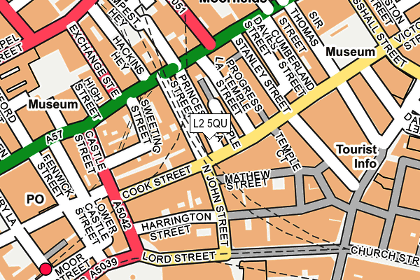
L2 5QU is located in the City Centre North electoral ward, within the metropolitan district of Liverpool and the English Parliamentary constituency of Liverpool, Riverside. The Sub Integrated Care Board (ICB) Location is NHS Cheshire and Merseyside ICB - 99A and the police force is Merseyside. This postcode has been in use since January 1980.


GetTheData
Source: OS OpenMap – Local (Ordnance Survey)
Source: OS VectorMap District (Ordnance Survey)
Licence: Open Government Licence (requires attribution)
| Easting | 334375 |
| Northing | 390448 |
| Latitude | 53.406750 |
| Longitude | -2.988619 |
GetTheData
Source: Open Postcode Geo
Licence: Open Government Licence
| Country | England |
| Postcode District | L2 |
| ➜ L2 open data dashboard ➜ See where L2 is on a map ➜ Where is Liverpool? | |
GetTheData
Source: Land Registry Price Paid Data
Licence: Open Government Licence
Elevation or altitude of L2 5QU as distance above sea level:
| Metres | Feet | |
|---|---|---|
| Elevation | 10m | 33ft |
Elevation is measured from the approximate centre of the postcode, to the nearest point on an OS contour line from OS Terrain 50, which has contour spacing of ten vertical metres.
➜ How high above sea level am I? Find the elevation of your current position using your device's GPS.
GetTheData
Source: Open Postcode Elevation
Licence: Open Government Licence
| Ward | City Centre North |
| Constituency | Liverpool, Riverside |
GetTheData
Source: ONS Postcode Database
Licence: Open Government Licence
| January 2024 | Anti-social behaviour | On or near Fazakerley Street | 436m |
| January 2024 | Anti-social behaviour | On or near Fazakerley Street | 436m |
| January 2024 | Criminal damage and arson | On or near Fazakerley Street | 436m |
| ➜ Get more crime data in our Crime section | |||
GetTheData
Source: data.police.uk
Licence: Open Government Licence
| Victoria Street | Liverpool | 27m |
| North John Street (Cook Street) | Liverpool | 48m |
| Victoria Street | Liverpool | 51m |
| Victoria Street | Liverpool | 77m |
| Union Court (Cook Street) | Liverpool | 93m |
| Moorfields Station | 0.2km |
| Liverpool James Street Station | 0.3km |
| Liverpool Central Station | 0.7km |
GetTheData
Source: NaPTAN
Licence: Open Government Licence
GetTheData
Source: ONS Postcode Database
Licence: Open Government Licence


➜ Get more ratings from the Food Standards Agency
GetTheData
Source: Food Standards Agency
Licence: FSA terms & conditions
| Last Collection | |||
|---|---|---|---|
| Location | Mon-Fri | Sat | Distance |
| Victoria Street | 18:30 | 66m | |
| Victoria Street | 18:30 | 12:00 | 71m |
| North John Street | 18:30 | 12:00 | 98m |
GetTheData
Source: Dracos
Licence: Creative Commons Attribution-ShareAlike
| Facility | Distance |
|---|---|
| Jd Gyms (Liverpool City Centre) Dale Street, Liverpool Health and Fitness Gym, Studio | 82m |
| Lifestyles Millennium (Closed) Victoria Street, Liverpool One, Liverpool Health and Fitness Gym, Studio | 316m |
| The Racquet Club Chapel Street, Liverpool Health and Fitness Gym, Squash Courts | 373m |
GetTheData
Source: Active Places
Licence: Open Government Licence
| School | Phase of Education | Distance |
|---|---|---|
| Holy Cross Catholic Primary School Fontenoy Street, Liverpool, L3 2DU | Primary | 691m |
| St Vincent de Paul Catholic Primary School St Vincent de Paul Catholic Primary School Pitt Street, Liverpool, L1 5BY | Primary | 881m |
| Pleasant Street Primary School Pleasant Street, Liverpool, L3 5TS | Primary | 1km |
GetTheData
Source: Edubase
Licence: Open Government Licence
The below table lists the International Territorial Level (ITL) codes (formerly Nomenclature of Territorial Units for Statistics (NUTS) codes) and Local Administrative Units (LAU) codes for L2 5QU:
| ITL 1 Code | Name |
|---|---|
| TLD | North West (England) |
| ITL 2 Code | Name |
| TLD7 | Merseyside |
| ITL 3 Code | Name |
| TLD72 | Liverpool |
| LAU 1 Code | Name |
| E08000012 | Liverpool |
GetTheData
Source: ONS Postcode Directory
Licence: Open Government Licence
The below table lists the Census Output Area (OA), Lower Layer Super Output Area (LSOA), and Middle Layer Super Output Area (MSOA) for L2 5QU:
| Code | Name | |
|---|---|---|
| OA | E00176652 | |
| LSOA | E01033760 | Liverpool 060C |
| MSOA | E02006932 | Liverpool 060 |
GetTheData
Source: ONS Postcode Directory
Licence: Open Government Licence
| L2 5QA | Victoria Street | 20m |
| L2 6RG | Victoria Street | 39m |
| L2 5RH | Temple Street | 55m |
| L2 5BA | Temple Lane | 59m |
| L2 4SA | North John Street | 64m |
| L2 9RF | Cook Street | 65m |
| L2 5QS | Victoria Street | 68m |
| L2 9RU | North John Street | 77m |
| L2 5BB | Temple Lane | 81m |
| L2 9RP | North John Street | 84m |
GetTheData
Source: Open Postcode Geo; Land Registry Price Paid Data
Licence: Open Government Licence