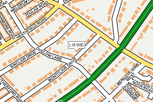
L18 0HD is located in the Church electoral ward, within the metropolitan district of Liverpool and the English Parliamentary constituency of Liverpool, Wavertree. The Sub Integrated Care Board (ICB) Location is NHS Cheshire and Merseyside ICB - 99A and the police force is Merseyside. This postcode has been in use since July 1983.


GetTheData
Source: OS OpenMap – Local (Ordnance Survey)
Source: OS VectorMap District (Ordnance Survey)
Licence: Open Government Licence (requires attribution)
| Easting | 339878 |
| Northing | 388668 |
| Latitude | 53.391409 |
| Longitude | -2.905513 |
GetTheData
Source: Open Postcode Geo
Licence: Open Government Licence
| Country | England |
| Postcode District | L18 |
| ➜ L18 open data dashboard ➜ See where L18 is on a map ➜ Where is Liverpool? | |
GetTheData
Source: Land Registry Price Paid Data
Licence: Open Government Licence
Elevation or altitude of L18 0HD as distance above sea level:
| Metres | Feet | |
|---|---|---|
| Elevation | 60m | 197ft |
Elevation is measured from the approximate centre of the postcode, to the nearest point on an OS contour line from OS Terrain 50, which has contour spacing of ten vertical metres.
➜ How high above sea level am I? Find the elevation of your current position using your device's GPS.
GetTheData
Source: Open Postcode Elevation
Licence: Open Government Licence
| Ward | Church |
| Constituency | Liverpool, Wavertree |
GetTheData
Source: ONS Postcode Database
Licence: Open Government Licence
| August 2023 | Burglary | On or near Rutherford Road | 303m |
| June 2023 | Other theft | On or near Rutherford Road | 303m |
| May 2023 | Vehicle crime | On or near Rutherford Road | 303m |
| ➜ Get more crime data in our Crime section | |||
GetTheData
Source: data.police.uk
Licence: Open Government Licence
| Montclair Drive (Woolton Road) | Wavertree | 103m |
| Beauclair Drive (Woolton Road) | Wavertree | 133m |
| Dunbabin Road (Woolton Road) | Wavertree | 172m |
| Woolton Road (Dunbabin Road) | Wavertree | 213m |
| Dudlow Lane (Heathfield Road) | Mossley Hill | 239m |
| Mossley Hill Station | 1.5km |
| Broad Green Station | 1.9km |
| Wavertree Technology Park Station | 1.9km |
GetTheData
Source: NaPTAN
Licence: Open Government Licence
| Percentage of properties with Next Generation Access | 100.0% |
| Percentage of properties with Superfast Broadband | 100.0% |
| Percentage of properties with Ultrafast Broadband | 100.0% |
| Percentage of properties with Full Fibre Broadband | 100.0% |
Superfast Broadband is between 30Mbps and 300Mbps
Ultrafast Broadband is > 300Mbps
| Percentage of properties unable to receive 2Mbps | 0.0% |
| Percentage of properties unable to receive 5Mbps | 0.0% |
| Percentage of properties unable to receive 10Mbps | 0.0% |
| Percentage of properties unable to receive 30Mbps | 0.0% |
GetTheData
Source: Ofcom
Licence: Ofcom Terms of Use (requires attribution)
GetTheData
Source: ONS Postcode Database
Licence: Open Government Licence


➜ Get more ratings from the Food Standards Agency
GetTheData
Source: Food Standards Agency
Licence: FSA terms & conditions
| Last Collection | |||
|---|---|---|---|
| Location | Mon-Fri | Sat | Distance |
| Dudlow Lane | 16:00 | 12:00 | 146m |
| Lance Lane Post Office | 17:15 | 12:00 | 407m |
| Heathfield Road | 17:15 | 12:00 | 453m |
GetTheData
Source: Dracos
Licence: Creative Commons Attribution-ShareAlike
| Facility | Distance |
|---|---|
| Carmel Sports Club Dunbabin Road, Dunbabin Road, Wavertree, Liverpool Outdoor Tennis Courts | 186m |
| Exclusive Fitness & Beauty Lounge (Ladies Only) (Closed) Woolton Road, Childwall, Liverpool Health and Fitness Gym, Studio | 400m |
| King David High School (Closed) Childwall Road, Liverpool Swimming Pool, Sports Hall | 614m |
GetTheData
Source: Active Places
Licence: Open Government Licence
| School | Phase of Education | Distance |
|---|---|---|
| Mosspits Lane Primary School Mosspits Lane, Liverpool, L15 6UN | Primary | 342m |
| Our Lady's Bishop Eton Catholic Primary School Green Lane, Mossley Hill, Liverpool, L18 2EP | Primary | 521m |
| King David Primary School Childwall Rd, Liverpool, L15 6WU | Primary | 589m |
GetTheData
Source: Edubase
Licence: Open Government Licence
The below table lists the International Territorial Level (ITL) codes (formerly Nomenclature of Territorial Units for Statistics (NUTS) codes) and Local Administrative Units (LAU) codes for L18 0HD:
| ITL 1 Code | Name |
|---|---|
| TLD | North West (England) |
| ITL 2 Code | Name |
| TLD7 | Merseyside |
| ITL 3 Code | Name |
| TLD72 | Liverpool |
| LAU 1 Code | Name |
| E08000012 | Liverpool |
GetTheData
Source: ONS Postcode Directory
Licence: Open Government Licence
The below table lists the Census Output Area (OA), Lower Layer Super Output Area (LSOA), and Middle Layer Super Output Area (MSOA) for L18 0HD:
| Code | Name | |
|---|---|---|
| OA | E00033409 | |
| LSOA | E01006592 | Liverpool 041D |
| MSOA | E02001387 | Liverpool 041 |
GetTheData
Source: ONS Postcode Directory
Licence: Open Government Licence
| L18 0HH | Dudlow Lane | 59m |
| L18 0HB | Montclair Drive | 62m |
| L18 2DX | Queens Drive | 94m |
| L18 0HW | Sinclair Drive | 115m |
| L15 6XW | Woolton Road | 145m |
| L18 2DS | Queens Drive | 159m |
| L18 0HA | Montclair Drive | 176m |
| L15 9HA | Heathfield Road | 188m |
| L18 0HE | Queens Drive | 199m |
| L18 2ET | Menlove Gardens West | 204m |
GetTheData
Source: Open Postcode Geo; Land Registry Price Paid Data
Licence: Open Government Licence